Big Four (War Eagle) Mine – Death Valley National Park


Hike up an old road to a few old mining audits, an ore chute, and more.
| Total Distance: 0.6 miles out & back | Elevation Gain: 454ft. (2,424ft. to 2,805ft.) |
| Difficulty: Easy | 0-5 Mile Difficulty: Easy |
| View Rating: 3.0 out of 5.0 stars | Author’s Rating: 3.0 out of 5.0 stars |
| Visitor Rating: (Click to rate) [Total: 0 Average: 0] | Visitor Difficulty Rating: (Click to rate) [Total: 0 Average: 0] |
| Pets: No | Horses: Yes, though a horse would struggle with much of the route |
| Best Seasons: November-April | Special Permits: None |
| Water Availability: None | Overnight Options: Dispersed camping permitted |
| Trailhead Amenities: None | Crowd Factor: Solitude |
| Trailhead Access: 0.8 | |
| Uses: | Trail Surface: |
| Features: | Hazards: |
Mile-by-Mile: Big Four (War Eagle) Mine
0.0 Approximate end of drivable Lake Hill Road (2,424ft.). A sign designates the road to the east as wilderness. Do not drive beyond the wilderness boundary. Instead, hike up the wash toward the mine, which should be visible on the hillside to the east. (Note: Most explorers will have to leave their vehicle behind well before the sign; hike up the rest of the Lake Hill Road to the sign to “begin” the hike.) (36.4316630°, -117.3925090°)
0.1 Leave Wash (2,511ft.). The hillside to the left looks like it has been washed out – this is the beginning of an old mining road. Follow the road in an A-shaped switchback up to some old audits and an ore chute. (36.4312520°, -117.3907080°)
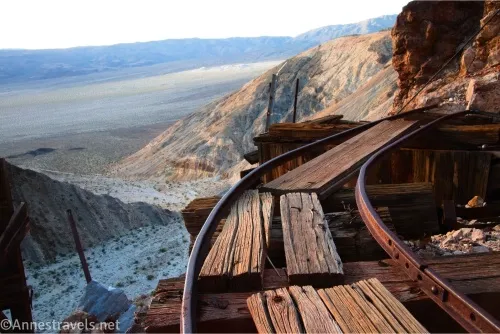
0.2 Ore chute (2,638ft.). This is the end of the easily accessible trail. However, it is possible to scramble up a scrabbly, loose, steep slope (sketchy Class 3+) to the right of the ore bin to more old mine workings and audits. Explore carefully and respectfully, staying out of any and all mines. Remember, this was a silver-lead mine, so there is plenty of lead dust and other toxic waste around. (36.4309480°, -117.3898730°)
History & More
The Big Four Mine (also known as the War Eagle Mine and the Perry Lead Mine) was one of the last claims to be staked in what is now Death Valley National Park. It was established as three claims by William Reid in 1940; 370 tons of ore was extracted from 1944 to 1945, and it was worked on and off at least until 1952. The ore averaged 16% lead, 12% zinc, and 2% silver.
If you want, you can continue up the canyon. An old townsite (possibly without any real evidence that it existed) is up this way along with some not-very-interesting narrows.
Download Route Map
Coming soon!
Driving Directions
The trailhead is at the end of the Lake Hill Road, 7.2 miles from CA-190. Without 4×4, you’ll need to park in the Panamint Dunes Parking Area and hike the 1.5 miles up the road to its end. Few 4×4 vehicles are rugged enough to make it to the end of the road, especially the final 0.25 miles. Drive as far as you’re comfortable, park out of the way of the non-existent traffic, and hike the remainder of the road.
It is extremely dangerous to enter a mine due to unstable shafts, gasses, and more. Do not enter mines, even if they are apparently open!
Walking on, climbing, entering, ascending, descending, or traversing any mine, structure, feature, or ruin is prohibited.
Toxic chemicals or ore may be present around mine sites. Enter at your own risk.
Possessing, destroying, injuring, defacing, removing, digging, or disturbing any mine, structure, feature, or ruin is also prohibited.
Always be wary of flash floods in a canyon.
Camping in a canyon is discouraged due to the danger of flash floods.
Remember, it may be easier to climb up dryfalls than down them (or vice versa). Be sure you can climb in the other direction before climbing up or down a dryfall.
Camping is not allowed within one mile of a paved road, developed area, or dirt road that is closed to camping.
Camping is not permitted within 100 feet of a flowing stream, spring, or other natural body of open water.
No camping is permitted on the floor of Death Valley, within one mile of Darwin Falls and Greenwater Canyon, on the active/shifting sand dunes, and certain other canyons and backcountry areas.
Camping is also prohibited within one mile of the Ubehebe Lead Mine, Leadfield Mines, Keane Wonder Mill, and Skidoo Mill.
Camping is limited to 30 days per calendar year within the park.
Fires are permitted in NPS-provided fire grates or grills ONLY.
Leave No Trace Principles are enforced
Drones and model aircrafts are prohibited
Camping is permitted only in designated sites or in areas open to dispersed backcountry camping
All park rules and regulations
12 Month Pass: $55/Death Valley Annual Pass (valid at Death Valley National Park). $80/America the Beautiful Annual Pass (valid at all national park and federal fee areas). $20/Annual Senior Pass (62 years or older US citizens; valid at all national park and federal fee areas). Free/4th Grade Pass (Valid Sept. 1-August 31 of the child’s 4th Grade school year). Free/Military Pass (valid for all active military personel and their dependents with a CAC Card or DD Form 1173).
Lifetime Pass: $80/Lifetime Senior Pass (62 years or older US citizens; valid at all national park and federal fee areas). Free/Access Pass (available to all US citizens with perminent disabilities). Free/Access for Veterans and Gold Star Families Pass (valid for all military and veterans with a CAC card, Veteran HJealth Identification Card, Veteran ID Card, or veteran’s designation on state-issued drivers license or identification card.)