
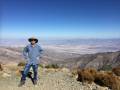
Abandoned Trail Canyon Mine Road – Death Valley National Park


Photo credit The Greater Southwestern Exploration Company, CC BY 2.0. View at https://flic.kr/p/2oZsJ7Z
Old mining road beyond the end of the Trail Canyon Road up to an old mine.
| Total Distance: 5.8 miles out & back | Elevation Gain: 2,678ft. (4,254ft. to 6,527ft.) |
| Difficulty: Easy | 5-10 Mile Difficulty: Easy |
| View Rating: 2.0 out of 5.0 stars | Author’s Rating: 1.0 out of 5.0 stars |
| Visitor Rating: (Click to rate) [Total: 0 Average: 0] | Visitor Difficulty Rating: (Click to rate) [Total: 0 Average: 0] |
| Pets: No | Horses: Yes |
| Best Seasons: March-June, September-December | Special Permits: None |
| Water Availability: None | Overnight Options: Dispersed camping permitted |
| Trailhead Amenities: None | Crowd Factor: Solitude |
| Trailhead Access: 2.0 | |
| Uses: | Trail Surface: |
| Features: | Hazards: |
Mile-by-Mile: Abandoned Trail Canyon Mine Road
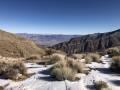
0.0 End of Trail Canyon Road/Old Mining Camp (4,254ft.). Continue on the road southwest back down into the South Fork of Trail Canyon (the wash). Walk south, following the canyon as it twists its way into the mountains. (36.303141°, -117.047923°)
0.8 Canyon Junction (4,763ft.). Turn left up a side canyon to walk south. (36.292448°, -117.050997°)
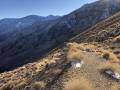
1.0 Mining road leaves wash (4,945ft.). Turn right to walk north up the mining road that zigzags up the hillside. It might look more like a wash at this point than a road. (36.289215°, -117.051483°)
2.5 Road split (6,266ft.). The right road ends after a short distance at an old mining area, so turn left to continue along the side of the ridge. (36.285199°, -117.060357°)
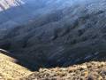
2.7 Road split (6,389ft.). Roads seem to go right, left, and straight. Going right ends quickly, and the left and straight routes end in more or less the same place. This route goes straight. (36.282927°, -117.060852°)
2.9 End of road (6,396ft.). A building is a short distance southeast of the end of the road. (approx. 36.279925°, -117.061385°)
History & More
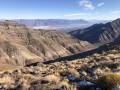
It is likely possible from the end of the road to continue up the canyon to the ridgeline – as it happens, the Wildrose Peak Trail runs along the ridgeline, offering access to the peak and fantastic views of the High Sierras to Nevada.
Miners made roads to all – or at least most – of their mines in order to transport supplies to the mines and ore down to processing facilities. Sometimes these roads become a regular worm’s nest that is fun – but also confusing – to explore.
Do not enter any mines or alter any mining structures.
Download Route Map
Driving Directions
Begin at the end of the Trail Canyon Road, 10.7 miles from the West Side Road.
It is extremely dangerous to enter a mine due to unstable shafts, gasses, and more. Do not enter mines, even if they are apparently open!
Walking on, climbing, entering, ascending, descending, or traversing any mine, structure, feature, or ruin is prohibited.
Toxic chemicals or ore may be present around mine sites. Enter at your own risk.
Possessing, destroying, injuring, defacing, removing, digging, or disturbing any mine, structure, feature, or ruin is also prohibited.
Always be wary of flash floods in a canyon.
Camping in a canyon is discouraged due to the danger of flash floods.
Remember, it may be easier to climb up dryfalls than down them (or vice versa). Be sure you can climb in the other direction before climbing up or down a dryfall.
Camping is not allowed within one mile of a paved road, developed area, or dirt road that is closed to camping.
Camping is not permitted within 100 feet of a flowing stream, spring, or other natural body of open water.
No camping is permitted on the floor of Death Valley, within one mile of Darwin Falls and Greenwater Canyon, on the active/shifting sand dunes, and certain other canyons and backcountry areas.
Camping is also prohibited within one mile of the Ubehebe Lead Mine, Leadfield Mines, Keane Wonder Mill, and Skidoo Mill.
Camping is limited to 30 days per calendar year within the park.
Fires are permitted in NPS-provided fire grates or grills ONLY.
Leave No Trace Principles are enforced
Drones and model aircrafts are prohibited
Camping is permitted only in designated sites or in areas open to dispersed backcountry camping
All park rules and regulations
12 Month Pass: $55/Death Valley Annual Pass (valid at Death Valley National Park). $80/America the Beautiful Annual Pass (valid at all national park and federal fee areas). $20/Annual Senior Pass (62 years or older US citizens; valid at all national park and federal fee areas). Free/4th Grade Pass (Valid Sept. 1-August 31 of the child’s 4th Grade school year). Free/Military Pass (valid for all active military personel and their dependents with a CAC Card or DD Form 1173).
Lifetime Pass: $80/Lifetime Senior Pass (62 years or older US citizens; valid at all national park and federal fee areas). Free/Access Pass (available to all US citizens with perminent disabilities). Free/Access for Veterans and Gold Star Families Pass (valid for all military and veterans with a CAC card, Veteran HJealth Identification Card, Veteran ID Card, or veteran’s designation on state-issued drivers license or identification card.)