Lake Hill (Chocolate Drops) – Death Valley National Park


Take an off-trail route up a hill to views of the Panamint Valley. During wet weather, the hill may be surrounded by a lake.
| Total Distance: 2.9 miles out & back | Elevation Gain: 793ft. (1,548ft. to 2,027ft.) |
| Difficulty: Moderate | 0-5 Mile Difficulty: Moderately Strenuous |
| View Rating: 4.0 out of 5.0 stars | Author’s Rating: 4.0 out of 5.0 stars |
| Visitor Rating: (Click to rate) [Total: 0 Average: 0] | Visitor Difficulty Rating: (Click to rate) [Total: 0 Average: 0] |
| Pets: No | Horses: Yes |
| Best Seasons: November-April | Special Permits: None |
| Water Availability: None | Overnight Options: Dispersed camping permitted |
| Trailhead Amenities: None | Crowd Factor: Solitude |
| Trailhead Access: 1.4 High clearance-appreicated dirt/gravel road | |
| Uses: | Trail Surface: |
| Features: | Hazards: |
Mile-by-Mile: Lake Hill (Chocolate Drops)
0.0 Lake Hill Road beyond Lake Hill (1,559ft.). Park just north of Lake Hill, either in the campsite on the east (right) side of the road or by the wilderness signs on the west (left) side of the road – be sure not to block the road. (The map shows the route as though you parked by the wilderness signs.) Set off south, heading for the north end of the ridge of hills of which Lake Hill is the tallest. You may notice that there are actually two ridges of dark hills that parallel each other with a wash/valley in between – you want the westerly (right) of the two ridges (but not the lone hill west and north of the two ridges). Work your way up the north side of the ridge to the first summit – you may encounter a trail along the way. (36.4033630°, -117.4032880°)
0.4 First Summit (1,763ft.). Continue down the other side generally along the ridgeline, then rise on the ridgeline to the second summit. (36.3981860°, -117.4042110°)
0.6 Second Summit (1,707ft.). Continue along the ridgeline. (36.3947240°, -117.4050280°)
0.8 Third Summit (1,756ft.). From here, drop into a low saddle, then continue up along the ridgeline to the next ridgeline. (36.3928180°, -117.4054040°)
1.0 Fourth Summit (1,876ft.). Continue to follow the ridgeline up to its high point – this is the summit of Lake Hill. (36.3893860°, -117.4061050°)
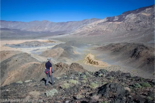
1.4 Lake Hill Summit (2,027ft.). Enjoy great views of the Argus, Cottonwood, and Panamint Mountains as well as the Panamint Valley Playa. When you’re ready to return to your vehicle, walk back along the ridgeline to drop into the low saddle. Turn right to drop into the small valley to the east of Lake Hill via a sandy, unstable slope. Once in the valley, walk north down the wash (don’t walk on the playa if it’s wet, and try to leave no footprints) and return to where you parked your vehicle. (36.384739°, -117.404473°)
2.9 Lake Hill Road beyond Lake Hill (1,559ft.). (36.401696°, -117.401203°)
History & More
It’s possible that Lake Hill received its name from the “lake” that sometimes fills this part of Panamint Valley and creates the playa you can see around the peak. Do not walk on the playa if it’s wet.
Some people have noted the similarity between the Grandstand on the Racetrack vs. Lake Hill on the Panamint Valley Playa – though Lake Hill is quite a bit larger than the Grandstand.
Some call Lake Hill the “Chocolate Drops.” It’s not hard to see how the mountains were given that name!
While no trail officially ascends Lake Hill, there is a trail in places. Please use it so as to cut down on confusing social paths for future visitors.
The tread of the hike is often rocky, but there are also sections of sand, playa, and of course cross-desert trekking.
Download Route Map
Coming soon!
Driving Directions
Follow the Lake Hill Road for 4.3 miles from CA-190. Park in the campsite on the right (east) side of the road, or near the wilderness signs on the left (west) side of the road shortly after passing Lake Hill.
Camping is not permitted within 100 feet of a flowing stream, spring, or other natural body of open water.
No camping is permitted on the floor of Death Valley, within one mile of Darwin Falls and Greenwater Canyon, on the active/shifting sand dunes, and certain other canyons and backcountry areas.
Camping is also prohibited within one mile of the Ubehebe Lead Mine, Leadfield Mines, Keane Wonder Mill, and Skidoo Mill.
Camping is limited to 30 days per calendar year within the park.
Fires are permitted in NPS-provided fire grates or grills ONLY.
Leave No Trace Principles are enforced
Drones and model aircrafts are prohibited
Camping is permitted only in designated sites or in areas open to dispersed backcountry camping
All park rules and regulations
12 Month Pass: $55/Death Valley Annual Pass (valid at Death Valley National Park). $80/America the Beautiful Annual Pass (valid at all national park and federal fee areas). $20/Annual Senior Pass (62 years or older US citizens; valid at all national park and federal fee areas). Free/4th Grade Pass (Valid Sept. 1-August 31 of the child’s 4th Grade school year). Free/Military Pass (valid for all active military personel and their dependents with a CAC Card or DD Form 1173).
Lifetime Pass: $80/Lifetime Senior Pass (62 years or older US citizens; valid at all national park and federal fee areas). Free/Access Pass (available to all US citizens with perminent disabilities). Free/Access for Veterans and Gold Star Families Pass (valid for all military and veterans with a CAC card, Veteran HJealth Identification Card, Veteran ID Card, or veteran’s designation on state-issued drivers license or identification card.)