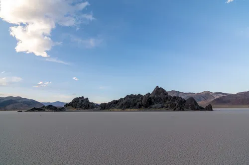
The Grandstand – Death Valley National Park


Hike across the playa to a rib of rocks offering a fantastic view.
| Total Distance: 0.75 mile lollipop loop + scrambling | Elevation Gain: 10ft. (3,705ft. to 3,712ft.) |
| Difficulty: Easy | 0-5 Mile Difficulty: Easy |
| View Rating: 5.0 out of 5.0 stars | Author’s Rating: 5.0 out of 5.0 stars |
| Visitor Rating: (Click to rate) [Total: 0 Average: 0] | Visitor Difficulty Rating: (Click to rate) [Total: 0 Average: 0] |
| Pets: No | Horses: No |
| Best Seasons: November-April | Special Permits: None |
| Water Availability: None | Overnight Options: None |
| Trailhead Amenities: None | Crowd Factor: Moderate to Solitude |
| Trailhead Access: 1.9 | |
| Uses: | Trail Surface: |
| Features: | Hazards: |
Mile-by-Mile: The Grandstand
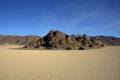
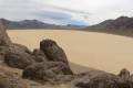
0.0 The Grandstand Parking Area (3,707ft.). Walk east onto the dried mud of the playa. Do not walk on the mud if it is wet – your footprints will ruin the experience of visitors for many years to come. Head in the general direction of the Grandstand, a pile of rocks in the middle of the playa. (36.694298°, -117.571581°)
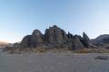
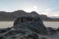
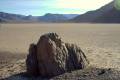
0.2 North end of the Grandstand (3,711ft.). Walk around the west or east side to circle the Grandstand. It’s very possible to scramble up into the rocks for great views, but do not attempt to climb the highest rock (Class 4+ scramble required). When you’re finished exploring, return to the parking area. (36.693526°, -117.567752°)
0.75 The Grandstand Parking Area (3,707ft.). (36.694298°, -117.571581°)
History & More
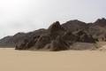
The Grandstand is mostly comprised of quartz-monzonite, an igneous rock that cooled slowly deep underground.
The southerly of the piles of rocks is the taller, though only by a few feet. It rises about 66ft. off of the flat surface of the playa.
It’s said that there is so much contrast between the Grandstand and the surrounding playa that it can be easily made out from an aircraft flying 100 miles away at 40,000ft. altitude.
A few people have had the strange phenomenon of seeing great blue herons perched on top of the Grandstand. The birds – which are well known to live in swamps and other well-watered areas – were in migration and decided to stop for a little rest in the middle of the desert.
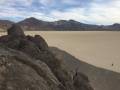
There are few or no “sailing stones” around the Grandstand. However, if you walk south and/or west, you may find some remote specimens.
Download Trail Map
Coming soon!
Driving Directions
Take the Racetrack Road from the Ubehebe Crater Road 25.3 miles from the crater. Turn left into the parking area for the Grandstand.
Leave No Trace Principles are enforced
Drones and model aircrafts are prohibited
Camping is permitted only in designated sites or in areas open to dispersed backcountry camping
Click here for all park rules and regulations
12 Month Pass: $55/Death Valley Annual Pass (valid at Death Valley National Park). $80/America the Beautiful Annual Pass (valid at all national park and federal fee areas). $20/Annual Senior Pass (62 years or older US citizens; valid at all national park and federal fee areas). Free/4th Grade Pass (Valid Sept. 1-August 31 of the child’s 4th Grade school year). Free/Military Pass (valid for all active military personel and their dependents with a CAC Card or DD Form 1173).
Lifetime Pass: $80/Lifetime Senior Pass (62 years or older US citizens; valid at all national park and federal fee areas). Free/Access Pass (available to all US citizens with perminent disabilities). Free/Access for Veterans and Gold Star Families Pass (valid for all military and veterans with a CAC card, Veteran HJealth Identification Card, Veteran ID Card, or veteran’s designation on state-issued drivers license or identification card.)
3 thoughts on “The Grandstand – Death Valley National Park”