Lake Hill Road – Death Valley National Park


The Lake Hill Road accesses the north end of Panamint Valley, including the Panamint Sand Dunes and the Big Four Mine.
| Total Distance: 7.2 miles point to point (CA-190 to dead end in wash) | Elevation Gain: 966ft. up, 131ft. down (1,549ft. to 2,498ft.) |
| Road Difficulty: 1.4 for the first 5.75 miles; 2.3 beyond; last 0.2 miles are 3.0 | Bicycle Difficulty: More Difficult to Very Difficult |
| View Rating: 3.0 out of 5.0 stars | Rating: 2.0 out of 5.0 stars |
| Visitor Rating: (Click to rate) [Total: 0 Average: 0] | Visitor Difficulty Rating: (Click to rate) [Total: 0 Average: 0] |
| Pets: Leashed | Horses: Yes |
| Best Seasons: October-May | Special Permits: None |
| Water Availability: None | Overnight Options: At least 1 mile from pavement. Please use preexisting sites. |
| Amenities: None | Crowd Factor: Moderate to Solitude |
| Uses: | Road surface: |
| Features: | Hazards: |
Mile-by-Mile: Lake Hill Road
0.0 Beginning of Lake Hill Road on CA-190 (1,563ft.). Drive north on the gravel road. The southernmost few miles are fairly low-clearance friendly as long as you drive slowly – small drainage dips require you to go slowly in almost any vehicle so you don’t bottom out. A series of washes about 1.6 miles may cause rough going, especially after storms. Enjoy views of the Cottonwood Mountains (east) and Argus Range (west). Pass by Lake Hill about mile 3; after this, the road swings toward the northwest. (36.341954°, -117.388783°)
5.75 Panamint Dunes Pulloff on left (1,591ft.). Continue straight on the road, which immediately turns to the northeast and becomes much rougher as it begins to ascend into the Cottonwood Mountains. A 4×4 vehicle is required beyond this point due to the rough, rocky, steep road – it’s so washed out that it’s hard to say how far you’ll be able to get in a vehicle. About halfway up the alluvial fan, the road has been rerouted to the left (north); on foot, this is more obvious than driving it in a vehicle (be careful to take the correct route on the way back down). As the road enters the canyon, it becomes so rocky and rough as to be nearly undrivable. About mile 7, the road drops into a wash – the final quarter mile can only be driven by a jeep or similar. (36.421323°, -117.411919°)
7.2 Approximate end of drivable road (2,398ft.). A sign designates the road to the east as wilderness. Do not drive beyond the wilderness boundary. (36.4316630°, -117.3925090°)
History & More
Don’t underestimate the difficulty of the road. It’s truly gnarly by the end. I wouldn’t take a non 4×4 vehicle more than a few yards beyond the Panamint Dunes pulloff.
The Lake Hill Road is a jump-off point for some great adventures. Since it’s not used for too much besides camping, any hikes you take will probably be pretty much by yourself. (No complaints there, right?)
I mostly know the Lake Hill Road as a great place to camp. There are several dispersed campsites, mostly spread out enough that you can’t hear the next campers plucking their guitar at all hours of the night. The road is also great for stargazing – the lights of most towns are so far away that there isn’t much light pollution. I have some great pictures (by my standards, anyway) of the Big Dipper from one night as we lay on a tarp chatting before bed.
As we were driving down Lake Hill Road one day in November, there was a sudden explosion of noise – it was so loud that I couldn’t hear myself screaming (literally). It turned out that a Navy jet was zooming overhead, very close to the ground, but it took me so long to figure it out that it was almost gone before I realized what had made the sound!
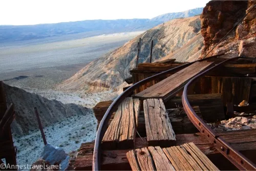
Panamint Dunes are the most often hiked route from the Lake Hill Road. I also hiked up to the Big 4 (War Eagle) Mine and up Lake Hill – all of which are great adventures!
Download Route Map
Coming soon!
Driving Directions
The beginning of the Lake Hill Road is along CA-190, 26 miles west of Stovepipe Wells and 4.6 miles east of the Panamint Springs Resort. It’s also exactly 2.0 miles east of where the Panamint Valley Road T’s into CA-190.
It is extremely dangerous to enter a mine due to unstable shafts, gasses, and more. Do not enter mines, even if they are apparently open!
Walking on, climbing, entering, ascending, descending, or traversing any mine, structure, feature, or ruin is prohibited.
Toxic chemicals or ore may be present around mine sites. Enter at your own risk.
Possessing, destroying, injuring, defacing, removing, digging, or disturbing any mine, structure, feature, or ruin is also prohibited.
Always be wary of flash floods in a canyon.
Camping in a canyon is discouraged due to the danger of flash floods.
Remember, it may be easier to climb up dryfalls than down them (or vice versa). Be sure you can climb in the other direction before climbing up or down a dryfall.
Camping is not allowed within one mile of a paved road, developed area, or dirt road that is closed to camping.
Camping is not permitted within 100 feet of a flowing stream, spring, or other natural body of open water.
No camping is permitted on the floor of Death Valley, within one mile of Darwin Falls and Greenwater Canyon, on the active/shifting sand dunes, and certain other canyons and backcountry areas.
Camping is also prohibited within one mile of the Ubehebe Lead Mine, Leadfield Mines, Keane Wonder Mill, and Skidoo Mill.
Camping is limited to 30 days per calendar year within the park.
Fires are permitted in NPS-provided fire grates or grills ONLY.
Leave No Trace Principles are enforced
Drones and model aircrafts are prohibited
Camping is permitted only in designated sites or in areas open to dispersed backcountry camping
All park rules and regulations
12 Month Pass: $55/Death Valley Annual Pass (valid at Death Valley National Park). $80/America the Beautiful Annual Pass (valid at all national park and federal fee areas). $20/Annual Senior Pass (62 years or older US citizens; valid at all national park and federal fee areas). Free/4th Grade Pass (Valid Sept. 1-August 31 of the child’s 4th Grade school year). Free/Military Pass (valid for all active military personel and their dependents with a CAC Card or DD Form 1173).
Lifetime Pass: $80/Lifetime Senior Pass (62 years or older US citizens; valid at all national park and federal fee areas). Free/Access Pass (available to all US citizens with perminent disabilities). Free/Access for Veterans and Gold Star Families Pass (valid for all military and veterans with a CAC card, Veteran HJealth Identification Card, Veteran ID Card, or veteran’s designation on state-issued drivers license or identification card.)