Echo Canyon Overlook – Death Valley National Park

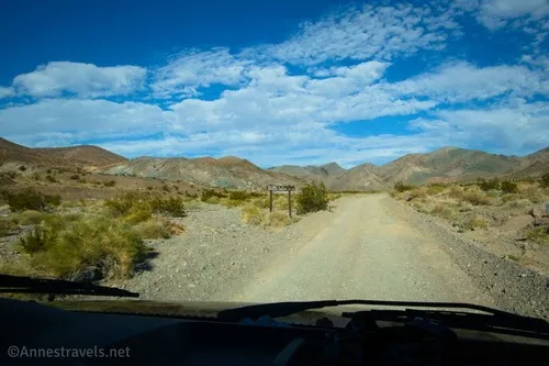
Take Echo Canyon – the longest canyon in the Funeral Mountains – to an overlook of the Amargosa Desert and the Shoshone Mountains. Total Distance: 6.8 miles out & back Elevation Gain: 698ft. (4,123ft. to 4,731ft.) Difficulty: 5-10 Mile Difficulty: View Rating: Author’s Rating: Visitor Rating: Visitor Difficulty Rating: Pets: No Horses: Yes Best Seasons: […]

Schwab Townsite – Death Valley National Park

Follow an old road to the site of a mining town and a view. Total Distance: 4.8 miles out & back Elevation Gain: 705ft. (3,146ft. to 3,811ft.) Difficulty: 0-5 Mile Difficulty: View Rating: Author’s Rating: Visitor Rating: Visitor Difficulty Rating: Pets: No Horses: Yes Best Seasons: November-April Special Permits: None Water Availability: None Overnight Options: […]

Echo Canyon Road – Death Valley National Park

Gravel/dirt road that gives access to Eye of the Needle Arch and the Inyo Mine. Total Distance: 10.9 miles point to point Elevation Gain: 3,729ft. up, 27.5ft. down (410ft. to 4,120ft.) Road Difficulty: 1.4 for the first 3 miles; 2.0 beyond Bicycle Difficulty: Very Difficult View Rating: Author’s Rating: Visitor Rating: Visitor Difficulty Rating: Pets: […]

Corridor Canyon – Death Valley National Park

Hike down a canyon with fossils, narrows, and slippery dryfalls to a very straight, sheer-faced canyon deep in the Last Chance Range. Total Distance: 7.8 miles out & back with spur Elevation Gain: 1,980ft. (3,860ft. to 2,880ft.) Difficulty: 5-10 Mile Difficulty: View Rating: Author’s Rating: Visitor Rating: Visitor Difficulty Rating: Pets: No Horses: Yes Best […]

Bighorn Gorge – Death Valley National Park

An off-trail hike that is often backpacked into a desert canyon with dryfalls and short stretches of narrows. Total Distance: 20 miles out & back Elevation Gain: 5,414ft. (1,456ft. to 5,056ft.) Difficulty: 10+ Mile Difficulty: View Rating: Author’s Rating: Visitor Rating: Visitor Difficulty Rating: Pets: No Horses: Yes Best Seasons: November-April Special Permits: None Water […]

Upper Titus Canyon – Death Valley National Park

Walk up a colorful desert canyon to a narrow canyon. Total Distance: 9.5 miles out & back Elevation Gain: 2,435ft. (3,745ft. to 6,140ft.) Difficulty: 5-10 Mile Difficulty: View Rating: Author’s Rating: Visitor Rating: Visitor Difficulty Rating: Pets: No Horses: Yes Best Seasons: November-April Special Permits: None Water Availability: None Overnight Options: Yes at least 2.0 […]

Titanothere Canyon Shuttle Hike – Death Valley National Park

Hike down a remote desert canyon from Titus Canyon Road to Scotty’s Castle Road. Total Distance: 11.2 mile shuttle Elevation Gain: 23ft. up, 4,925ft. down (4,997ft. to 94ft.) Difficulty: going downcanyon; going upcanyon 10+ Mile Difficulty: going downcanyon; going upcanyon View Rating: Author’s Rating: Visitor Rating: Visitor Difficulty Rating: Pets: No Horses: Yes Best Seasons: […]

Monarch Canyon Road – Death Valley National Park

Rough dirt road down Upper Monarch Canyon to an old miner’s trail. Total Distance: 0.7 miles point to point (dead end) Elevation Gain: 12ft. up, 237ft. down (3,512ft. to 3,287ft.) Road Difficulty: 1.8 Bicycle Difficulty: More Difficult View Rating: Author’s Rating: Visitor Rating: Visitor Difficulty Rating: Pets: Leashed Horses: Yes Best Seasons: October-May Special Permits: […]

Keane Spring – Death Valley National Park

Follow an old mining road to a desert spring. Total Distance: 1.2 miles out & back Elevation Gain: 331t. (3,622ft. to 3,853ft.) Difficulty: 0-5 Mile Difficulty: View Rating: Author’s Rating: Visitor Rating: Visitor Difficulty Rating: Pets: No Horses: Yes Best Seasons: November-April Special Permits: None Water Availability: No potable water Overnight Options: Dispersed camping is […]