Echo Canyon Road – Death Valley National Park


Gravel/dirt road that gives access to Eye of the Needle Arch and the Inyo Mine.
| Total Distance: 10.9 miles point to point | Elevation Gain: 3,729ft. up, 27.5ft. down (410ft. to 4,120ft.) |
| Road Difficulty: 1.4 for the first 3 miles; 2.0 beyond | Bicycle Difficulty: Very Difficult |
| View Rating: 3.0 out of 5.0 stars | Author’s Rating: 2.0 out of 5.0 stars |
| Visitor Rating: (Click to rate) [Total: 0 Average: 0] | Visitor Difficulty Rating: (Click to rate) [Total: 0 Average: 0] |
| Pets: Leashed | Horses: Yes |
| Best Seasons: October-May | Special Permits: Free permit required to camp along the road |
| Water Availability: None | Overnight Options: At least 1 mile from the southern end of the road; no camping at the Inyo Mine; free permit required |
| Amenities: None | Crowd Factor: Moderate to Solitude |
| Uses: | Road surface: |
| Features: | Hazards: |
Mile-by-Mile: Echo Canyon Road
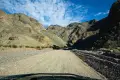
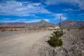
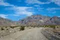
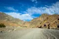
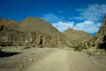
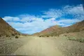
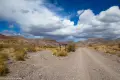
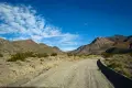
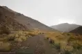
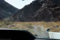
0.0 Echo Canyon Road on CA-190 (410ft.). Turn northeast up the dirt road. A sign says that no camping is allowed for the first mile off the pavement. The first three miles of the road are high-clearance friendly (I’ve seen low-clearance vehicles up to 1.5 miles from CA-190), although the road becomes rougher the higher you drive. You will see many places where people have pulled off the road to camp. At this point, the terrain is gravelly as you head northeast toward the Funeral Mountains. You’re basically driving up the alluvial fan of the wash below Echo Canyon. Enter the canyon about mile 2.5. 4×4 is likely required beyond mile 3, though a stock vehicle (like a family SUV) could probably make it without much trouble. (36.437606°, -116.824091°)
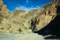
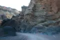
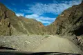
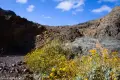
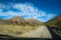
3.4 Enter Echo Canyon Narrows (1,610ft.). Continue to follow the road as it twists and turns up the (somewhat) narrow canyon. The walls are mostly lumpy brown rock, which is much more scenic than I just made it sound. There are also pretty sections of colorful rocks. (36.459006°, -116.772748°)
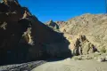
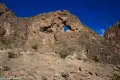
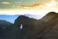
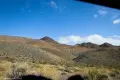
4.75 Eye of the Needle Arch (2,140ft.). Look up at the fin to the north (right) to see the arch. People have tried to climb up into it, but you’ll have to discover for yourself whether or not this is possible. As the road rounds the next bend, you can see the back side of the arch. The walls of the canyon are especially colorful after the arch and as you exit the narrows about mile 5.4 after an especially tight section of canyon. The “canyon” after this appears to be more of a broad valley as the road travels up the wash. (36.466585°, -116.759831°)
7.75 Road to Schwab Town Site on left (west) (3,145ft.). The old road is closed. Continue right (northeast) toward the Inyo Mine and Amargosa. (36.497130°, -116.732554°)
9.0 Lee’s Camp Road on left (north) (3,584ft.). Continue right on the road to the Inyo Mine. (36.496308°, -116.710683°)
9.5 Inyo Mine Parking Area (3,737ft.). A parking area on the north side of the road is for the mining area, which includes several old buildings and structures. However, as the area is private property, I won’t detail exploring it, including two forks of an old road that ascend the hillside. Most people turn around here at the mine, but the road continues up Echo Canyon. The road is rougher but still very doable in a stock vehicle most of the time. This section of the road was an old railroad grade (36.493320°, -116.703885°)
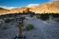
10.9 End of Echo Canyon Road (4,120ft.). A wilderness boundary marker bars further vehicle traffic. From here, you can walk the rest of the way up the canyon if desired. (36.495815°, -116.684620°)
History & More
Echo Canyon is technically the longest canyon in the Funeral Mountains.
In early 1905, Chet Leavitt and his partner Moroni Hicks crossed the Funeral Mountains into Echo Canyon in search of gold. While looking for their stray pack animals, the two found a vein of quartz. Early assays were not promising, but the two finally discovered a vein of gold a little further up the hill. When rich ore was discovered, Charles Schwab, a steel tycoon from Pennsylvania, took interest in developing the mine. The Inyo claim eventually boasted a blacksmith shop, boarding house, and store.
The gold found near Inyo could be worth nearly $300/ton – a fortune in that day. However, just as the mine was becoming profitable, a financial panic hit the mines in the area, and despite almost five years of negotiations, not a single shipment of gold was sent to market. The prospectors had staked out – but never mined – almost $650,000 of gold by the time the mine was abandoned.
The Inyo Mine was reopened in 1932 and again in 1938. However, neither venture was profitable, even when a 25-ton crushing mill was added in the final attempt at gold mining.
Worse than the financial difficulties, the area around Inyo lacked reliable water sources. Gold refining requires significant water supplies on top of the demands of water for thirsty miners. While water was pumped in from Furnace Creek, it simply wasn’t financially viable to transport the water necessary to run the mine.
Download Trail Map
Driving Directions
Take CA-190 3.4 miles east (toward and past Badwater Road) from the Furnace Creek Visitor Center. Or, from the east, follow CA-190 26.8 miles west from Death Valley Junction (Amargosa Opera House).
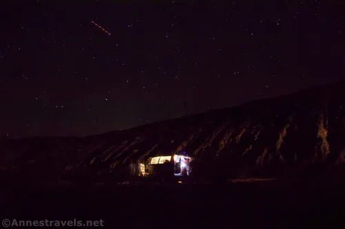
Camping in a canyon is discouraged due to the danger of flash floods.
Remember, it may be easier to climb up dryfalls than down them (or vice versa). Be sure you can climb in the other direction before climbing up or down a dryfall.
Camping is not allowed within one mile of a paved road, developed area, or dirt road that is closed to camping.
Camping is not permitted within 100 feet of a flowing stream, spring, or other natural body of open water.
No camping is permitted on the floor of Death Valley, within one mile of Darwin Falls and Greenwater Canyon, on the active/shifting sand dunes, and certain other canyons and backcountry areas.
Camping is also prohibited within one mile of the Ubehebe Lead Mine, Leadfield Mines, Keane Wonder Mill, and Skidoo Mill.
Camping is limited to 30 days per calendar year within the park.
Fires are permitted in NPS-provided fire grates or grills ONLY.
Leave No Trace Principles are enforced
Drones and model aircrafts are prohibited
Camping is permitted only in designated sites or in areas open to dispersed backcountry camping
All park rules and regulations
12 Month Pass: $55/Death Valley Annual Pass (valid at Death Valley National Park). $80/America the Beautiful Annual Pass (valid at all national park and federal fee areas). $20/Annual Senior Pass (62 years or older US citizens; valid at all national park and federal fee areas). Free/4th Grade Pass (Valid Sept. 1-August 31 of the child’s 4th Grade school year). Free/Military Pass (valid for all active military personel and their dependents with a CAC Card or DD Form 1173).
Lifetime Pass: $80/Lifetime Senior Pass (62 years or older US citizens; valid at all national park and federal fee areas). Free/Access Pass (available to all US citizens with perminent disabilities). Free/Access for Veterans and Gold Star Families Pass (valid for all military and veterans with a CAC card, Veteran HJealth Identification Card, Veteran ID Card, or veteran’s designation on state-issued drivers license or identification card.)
4 thoughts on “Echo Canyon Road – Death Valley National Park”