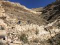
Upper Monarch Canyon to Monarch Spring – Death Valley National Park


Photo credit The Greater Southwestern Exploration Company, CC BY 2.0. View at https://flic.kr/p/2oTTzZ1

Walk an old mining road to a desert spring, an old stamp mill, and other historic ruins.
| Total Distance: 1.6 miles out & back | Elevation Gain: 428t. (3,291ft. to 2,933ft.) |
| Difficulty: Easy | 0-5 Mile Difficulty: Moderate |
| View Rating: 2.0 out of 5.0 stars | Author’s Rating: 2.0 out of 5.0 stars |
| Visitor Rating: (Click to rate) [Total: 0 Average: 0] | Visitor Difficulty Rating: (Click to rate) [Total: 0 Average: 0] |
| Pets: No | Horses: Yes |
| Best Seasons: November-April | Special Permits: None |
| Water Availability: No potable water | Overnight Options: Dispersed camping is permitted |
| Trailhead Amenities: None | Crowd Factor: Solitude |
| Trailhead Access: 1.8 | |
| Uses: | Trail Surface: |
| Features: | Hazards: |
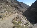
Mile-by-Mile: Upper Monarch Canyon to Monarch Spring
0.0 Old mining road/social trail leaves Monarch Canyon Road to the left (south) of the pouroff (3,287ft.). Take the trail south down into the canyon below the pouroff. The portion of the road just above the canyon floor may need to be scrambled, as floods have washed out the road. (36.729457°, -116.916909°)
0.1 Canyon bottom (3187ft.). The area is choked with reeds and rabbitbrush due to a seep nearby. Head downcanyon, where the brush subsides for clearer walking. (36.727962°, -116.917264°)
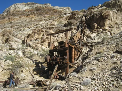
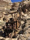
0.3 Indian Mine Stamp Mill (3,090ft.). A one-stamp mill once operated here; the ruins remain more or less intact. Perhaps more exciting to look at, a long ore chute runs down the cliff face; an ore car rail and a gold hopper are also nearby. As you continue downcanyon, keep your eyes open for relics and ruins of the mines. (36.725182°, -116.918937°)
0.8 Monarch Spring (2,933ft.). Follow the animal trails to the spring. Near the spring is a cabin and other ruins. From here, you can bushwack through the reeds and boggy canyon floor toward the top of Monarch Falls, but it’s hard going and you can’t see much from the top of the falls, so this trail guide ends here. (approx. 36.721749°, -116.922107°)
History & More
The “trail” to Monarch Spring was once a mining road. However, it is in very bad repair, and now only foot and horse traffic are permitted.
The Indian Mine was discovered by a Shoshone man by the name of Johnny Hughes while hunting for bighorn sheep. He told a man by the name of Ishmael about it. The latter struck the claim in December 1904, naming it in honor of the native man. Ishmael had dug a 60ft. shaft by January of 1906, but the San Francisco Earthquake, or perhaps other issues, brought development to a halt until March of 1909. The ore was valued as significant enough (about $20/ton) for Ismael and his partner to install a two-stamp mill. However, only one bullion was ever shipped out of the mine, and like many before and after it, the Indian Mine was abandoned.
During the Bullfrog gold boom, many prospectors tried their luck in the area of Chloride Cliffs. While no big, exceedingly profitable strikes were made, many discoveries were profitable enough to entice investors into the area for development.
Springs were a vital source of life for miners in the desert, and reliable water sources, like this one, were rare and cherished. At the very least, Monarch Spring supplied water to the miners who worked the stamp mill. It also probably supplied water for running the mill and other mining activities.
Remember to leave all of the historic area exactly as you found it.
Download Trail Map
Coming soon!
Driving Directions
Take the Chloride City Road 2.2 miles from the Daylight Pass Road. Turn right (south) onto the Monarch Canyon Road. After 0.7 miles, park at the end of the road. (If you don’t have 4×4, drive 0.6 miles on the Monarch Canyon Road, park without obstructing traffic, and walk the final tenth of a mile of the road to the pouroff.)
Camping in a canyon is discouraged due to the danger of flash floods.
Remember, it may be easier to climb up dryfalls than down them (or vice versa). Be sure you can climb in the other direction before climbing up or down a dryfall.
Camping is not allowed within one mile of a paved road, developed area, or dirt road that is closed to camping.
Camping is not permitted within 100 feet of a flowing stream, spring, or other natural body of open water.
No camping is permitted on the floor of Death Valley, within one mile of Darwin Falls and Greenwater Canyon, on the active/shifting sand dunes, and certain other canyons and backcountry areas.
Camping is also prohibited within one mile of the Ubehebe Lead Mine, Leadfield Mines, Keane Wonder Mill, and Skidoo Mill.
Camping is limited to 30 days per calendar year within the park.
Fires are permitted in NPS-provided fire grates or grills ONLY.
Leave No Trace Principles are enforced
Drones and model aircrafts are prohibited
Camping is permitted only in designated sites or in areas open to dispersed backcountry camping
All park rules and regulations
12 Month Pass: $55/Death Valley Annual Pass (valid at Death Valley National Park). $80/America the Beautiful Annual Pass (valid at all national park and federal fee areas). $20/Annual Senior Pass (62 years or older US citizens; valid at all national park and federal fee areas). Free/4th Grade Pass (Valid Sept. 1-August 31 of the child’s 4th Grade school year). Free/Military Pass (valid for all active military personel and their dependents with a CAC Card or DD Form 1173).
Lifetime Pass: $80/Lifetime Senior Pass (62 years or older US citizens; valid at all national park and federal fee areas). Free/Access Pass (available to all US citizens with perminent disabilities). Free/Access for Veterans and Gold Star Families Pass (valid for all military and veterans with a CAC card, Veteran HJealth Identification Card, Veteran ID Card, or veteran’s designation on state-issued drivers license or identification card.)
1 thought on “Upper Monarch Canyon to Monarch Spring – Death Valley National Park”