Ubehebe Canyon (49 Dryfall Canyon) – Death Valley National Park


This canyon boasts 49 dryfalls and 3 chokestones (give or take a few) for you to explore. The route is usually descended with ropes, but it is possible to free-climb and free-descend if you don’t mind some Class 3+ scrambling. The Lost Burro Mine can be accessed at the top of the canyon.
| Total Distance: 7.8 mile lollipop loop | Elevation Gain: 2,072ft. (3,707ft. to 5,607ft.) |
| Difficulty: Strenuous | 5-10 Mile Difficulty: Very Strenuous |
| View Rating: 5.0 out of 5.0 stars | Author’s Rating: 4.0 out of 5.0 stars |
| Visitor Rating: (Click to rate) [Total: 0 Average: 0] | Visitor Difficulty Rating: (Click to rate) [Total: 0 Average: 0] |
| Pets: No | Horses: Yes, but a horse could never do this hike |
| Best Seasons: November-April | Special Permits: None |
| Water Availability: None | Overnight Options: Dispersed camping permitted at least a mile outside of the Racetrack Valley |
| Trailhead Amenities: None | Crowd Factor: Solitude |
| Trailhead Access: 1.9 High clearance-required dirt/gravel road; 4×4 appreciated | |
| Uses: | Trail Surface: |
| Features: | Hazards: |
Mile-by-Mile: Ubehebe Canyon (49 Dryfall Canyon)
0.0 The Grandstand Parking Area (3,707ft.). Cross the road, pass through the fence, and walk east onto the dried mud of the playa. Do not walk on the mud if it is wet – your footprints will ruin the experience of visitors for many years to come. Head toward the left of the Grandstand, aiming for the mouth of the last major canyon to the left (north) of the playa. At the edge of the playa, follow washes or walk overland across the gravelly surface of the hills toward the canyon mouth. I just made it sound a lot easier than it is in real life, but it’s not too bad if you’re used to off-trail hiking in the desert. (36.694298°, -117.571581°)
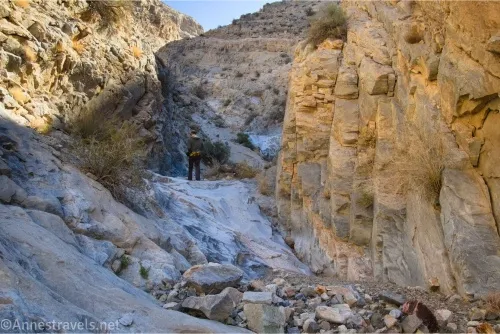
2.3 Drop into Ubehebe Canyon Wash (4,144ft.). You will need to descend into the wash here or further west, as the rim of the canyon begins to rise in steep cliffs to the east of here. Turn right (east) to walk up the rocky but quite passable wash. The canyon walls quickly rise above the wash; reach the canyon mouth 0.2 miles later. It doesn’t take long to encounter the first dryfall, though this is an easy scramble. From here, the canyon rises in a series of approximately 49 dryfalls and 3 chokestones (depending on how you want to count) over the next three-fourths of a mile. Occasionally, the dryfalls must be bypassed, usually on the left. One especially exciting section, perhaps half a mile from the canyon mouth, contains about seven dryfalls, one on top of the next – this is actually an easy ascent compared to some of the other dryfalls. (36.717439°, -117.541821°)
3.25 Canyon Junction (5,047ft.). The canyon splits here – you can go either direction; I opted to go up the right fork and down the left fork on my way back. Both are riddled with small (up to 10ft.) dryfalls, but I stopped counting at this point as they’re mostly quite easy to negotiate. (36.718056°, -117.526916°)
3.3 Canyon Junction (5,116ft.). Turn left here to rise up the wash, which is quickly becoming less canyon and more shallow, narrow drainage. If you want to visit the Lost Burro Mine, eventually, you’ll want to rise up the hillside to a small pass on the ridgeline (leave the wash approximately mile 3.7 and 36.721523°, -117.522186° and reach the ridgeline at approximately mile 3.8 and 36.722906°, -117.521856°), from which you can walk along the ridgeline to the upper reaches of the mine area or else you can descend the steep, slippery hillside to the middle or lower parts of the mine. If you just want to complete the canyon as a loop, continue up the drainage (this guide skips the mine). (36.718117°, -117.525918°)
4.0 Near the top of the drainage (5,607ft.). If you’d rather, you can continue up the drainage and then turn down, but this guide turns left here to scramble over the hill to the west and then drop into the next drainage (approx. 36.723983°, -117.525727°; mile 4.0). As you climb, be sure to look around – the views down to the Racetrack and across Hidden Valley are equally stunning, especially from higher on the hill. Once in the second drainage, turn left to walk downcanyon (south). Pass a couple of side canyons on your way down (namely mile 4.2 at 36.721783°, -117.527044° where you want to stay left and mile 4.4 at 36.719592°, -117.526472° where you want to stay right); it should be easy to stay in the main wash and keep heading downhill. (36.724122°, -117.524980°)
4.5 Return to the first Canyon Junction (5,047ft.). Turn right to retrace your steps down the 49 dryfalls and 3 choke stones. (36.718056°, -117.526916°)
5.5 Exit Ubehebe Wash (4,144ft.). Leave the Ubehebe Wash on the left (south) side and walk downhill in washes or on the gravelly desert back to the playa and then back to your vehicle. (36.717439°, -117.541821°)
7.8 Grandstand Trailhead (3,707ft.). (36.694298°, -117.571581°)
History & More
“Ubehebe Canyon” is an unofficial name for this gorge through the Last Chance Range. After hiking it, I had significant trouble finding its colloquial name, so I referred to it as “49 Dryfall Canyon.”
Does the canyon truly contain 49 dryfalls? It actually contains many more than 49, though it’s really dependent on how you want to count. I didn’t bother counting any dryfall less than 3ft. or any of the multiple dryfalls above the canyon split.
The scrambling in this canyon is significant. Two of us made it up – and down – mostly with Class 3 scrambling and a few ledgy but doable bypasses. Everyone else I’ve ever heard of taking the route has done it top-down from the Lost Burro Mine – and they all used ropes to rappel down the dryfalls.
Only go as far up the canyon as you’re comfortable climbing back down.
I truly enjoyed visiting the mine – be sure to descend high enough in the mine area that you don’t have to climb too far down the hillside, which is quite steep. There is quite a bit of old mining equipment and some very interesting history notebooks in the cabin.
The Lost Burro Mine can also be accessed via a road off of the Hunter Mountain Road – the route between the Racetrack Road and the Lost Burro Mine is typically accessible with a high-clearance or AWD vehicle, though 4×4 is recommended.
From the high point of this hike, you can continue north to ascend Lost Burro Peak for spectacular views of the surrounding area.
Download Route Map
Coming soon!
Driving Directions
Take the Racetrack Road from the Ubehebe Crater Road 25.3 miles from the crater. Turn right into the parking area for the Grandstand.
It is extremely dangerous to enter a mine due to unstable shafts, gasses, and more. Do not enter mines, even if they are apparently open!
Walking on, climbing, entering, ascending, descending, or traversing any mine, structure, feature, or ruin is prohibited.
Toxic chemicals or ore may be present around mine sites. Enter at your own risk.
Possessing, destroying, injuring, defacing, removing, digging, or disturbing any mine, structure, feature, or ruin is also prohibited.
Always be wary of flash floods in a canyon.
Camping in a canyon is discouraged due to the danger of flash floods.
Remember, it may be easier to climb up dryfalls than down them (or vice versa). Be sure you can climb in the other direction before climbing up or down a dryfall.
Camping is not allowed within one mile of a paved road, developed area, or dirt road that is closed to camping.
Camping is not permitted within 100 feet of a flowing stream, spring, or other natural body of open water.
No camping is permitted on the floor of Death Valley, within one mile of Darwin Falls and Greenwater Canyon, on the active/shifting sand dunes, and certain other canyons and backcountry areas.
Camping is also prohibited within one mile of the Ubehebe Lead Mine, Leadfield Mines, Keane Wonder Mill, and Skidoo Mill.
Camping is limited to 30 days per calendar year within the park.
Fires are permitted in NPS-provided fire grates or grills ONLY.
Leave No Trace Principles are enforced
Drones and model aircrafts are prohibited
Camping is permitted only in designated sites or in areas open to dispersed backcountry camping
All park rules and regulations
12 Month Pass: $55/Death Valley Annual Pass (valid at Death Valley National Park). $80/America the Beautiful Annual Pass (valid at all national park and federal fee areas). $20/Annual Senior Pass (62 years or older US citizens; valid at all national park and federal fee areas). Free/4th Grade Pass (Valid Sept. 1-August 31 of the child’s 4th Grade school year). Free/Military Pass (valid for all active military personel and their dependents with a CAC Card or DD Form 1173).
Lifetime Pass: $80/Lifetime Senior Pass (62 years or older US citizens; valid at all national park and federal fee areas). Free/Access Pass (available to all US citizens with perminent disabilities). Free/Access for Veterans and Gold Star Families Pass (valid for all military and veterans with a CAC card, Veteran HJealth Identification Card, Veteran ID Card, or veteran’s designation on state-issued drivers license or identification card.)