Racetrack Road – Death Valley National Park


A rough, unpaved, high-clearance-only road that leads to the famous lakebed with mysteriously moving rocks. Do not walk on the playa (mud) if it is wet.
| Total Distance: 29.5 miles point to point | Elevation Gain: 2,693ft. up, 1,419ft. down (2,476ft. to 4,956ft.) |
| Road Difficulty: 1.9 | Bicycle Difficulty: More Difficult |
| View Rating: 4.0 out of 5.0 stars | Author’s Rating: 4.0 out of 5.0 stars |
| Visitor Rating: (Click to rate) [Total: 0 Average: 0] | Visitor Difficulty Rating: (Click to rate) [Total: 0 Average: 0] |
| Pets: Leashed | Horses: Yes |
| Best Seasons: October-May | Special Permits: None |
| Water Availability: None | Overnight Options: Homestake Dry Camp is located at the end of the road, south of the Racetrack. Dispersed camping is permitted at least 1 mile south of the Ubehbe Crater Road and 2 miles north of Teakettle Junction (however, sites are almost non-existent, and the road is too narrow to safely pull over). |
| Amenities: None | Crowd Factor: Solitude to Moderate |
| Uses: | Road surface: |
| Features: | Hazards: |
Mile-by-Mile: Racetrack Road
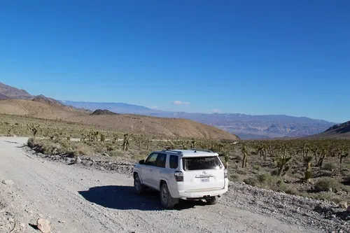
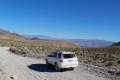
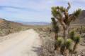
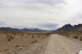
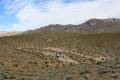
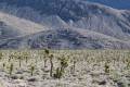
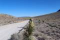
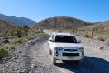
0.0 Racetrack Road Junction on the Ubehbe Crater Road (2,499ft.). Turn right toward the Racetrack. The road is narrow with sharp rocks; deep washboard slows travel to 10-15mph (due to the rocks, you don’t want to drive quickly). After storms, the road may be washed out and require 4×4. The road passes through Joshua tree forests and the desert, with nice views to the nearby mountains. (37.012849°, -117.457854°)
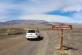
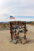
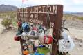
19.6 Teakettle Junction (4,143ft.). Here passersby have hung tea kettles from the road sign. The Hunter Mountain Road turns left; continue right (straight/west) on the Racetrack Road as it descends into the valley. (36.760023°, -117.542389°)
21.7 Roads on right (west) (3,988ft.). These roads lead to the Ubehebe Lead Mine via a very sketchy 4×4 road. Continue south on the main road. (36.745470°, -117.575193°)
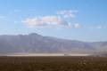
25.3 Parking area for the Grandstand on right (3,707ft.). Trails from here stretch west up to Ubehebe Peak and east out onto the playa to the Grandstand. Note that there are few or no sailing rocks in this area, though the Grandstand offers fantastic views. (36.694343°, -117.571558°)
27.3 Parking area for the Racetrack Playa on left (3,710ft.). This is where the famous “moving rocks” or “sailing stones” can be found. Day trippers should turn around here, though the road continues south. (36.665753°, -117.568350°)
29.0 Lippincott Road (Saline Valley Road) on right (3,793ft.). Continue straight (south) on the Racetrack Road. (36.641534°, -117.574570°)
29.3 Road split (3,774ft.). This is the Homestake Dry Camp, marking the end of the Racetrack Road. The road loops around past the 4×4 road to Lippincott Mine (on right) and back to the road split. (36.638143°, -117.574404°)
History & More
The Racetrack Road may be impassable or require 4×4 when wet.
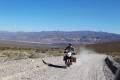
The Racetrack Road is hazardous due to the deep washboard, very sharp rocks (off-road tires are advised), and narrow width. It is nearly impossible to pass cars on the road in many places without driving up on the gravel along the edge of the road. While 4×4 is not necessary under most conditions, it is recommended – press the rangers for details if they tell you that you need 4×4 (sometimes 4×4 is required due to washouts). Bring spare tires and be prepared for self-rescue, as towing costs can run upwards of $1,000.
Most of the Racetrack Road was constructed by miners working the Ubehebe Lead Mine (in the Last Chance Range). The men needed a way to transport ore to civilization, not to mention supplies to their camp.
No one knows who left the first tea kettle at Teakettle Junction. Some say it was a landmark of some kind, or that water was nearby, or maybe just to leave a message to another traveler. Whatever the reason, it’s become an off-beat icon along the road.
You’re welcome to bring your own old teakettle and leave it at Teakettle Junction, along with a message to future travelers. (Don’t litter, though!) Many people have written where they’re from on their kettles, so you might want to take a few minutes to see what far-flung destinations you can discover. When too many kettles are hung from the sign, rangers thin them out to make space for new ones. When I arrived in the area, there were maybe half a dozen kettles on the sign; at least four were added before I left a few days later.
There are a fair number of mines along the southern part of the Racetrack Road. Because many of the mines were created to extract lead, you probably don’t want to explore among the piles of talus and other debris.
The Racetrack Valley is bordered by the Cottonwood Mountains to the east and the Nelson Mountains and Last Chance Range to the west.
Download Trail Map
Coming soon!
Driving Directions
The Racetrack Road begins at the end of the Ubehebe Crater Road, 5.7 miles from the Scotty’s Castle Road.
Leave No Trace Principles are enforced
Drones and model aircrafts are prohibited
Camping is permitted only in designated sites or in areas open to dispersed backcountry camping
Click here for all park rules and regulations
12 Month Pass: $55/Death Valley Annual Pass (valid at Death Valley National Park). $80/America the Beautiful Annual Pass (valid at all national park and federal fee areas). $20/Annual Senior Pass (62 years or older US citizens; valid at all national park and federal fee areas). Free/4th Grade Pass (Valid Sept. 1-August 31 of the child’s 4th Grade school year). Free/Military Pass (valid for all active military personel and their dependents with a CAC Card or DD Form 1173).
Lifetime Pass: $80/Lifetime Senior Pass (62 years or older US citizens; valid at all national park and federal fee areas). Free/Access Pass (available to all US citizens with perminent disabilities). Free/Access for Veterans and Gold Star Families Pass (valid for all military and veterans with a CAC card, Veteran HJealth Identification Card, Veteran ID Card, or veteran’s designation on state-issued drivers license or identification card.)
8 thoughts on “Racetrack Road – Death Valley National Park”