20 Mule Team Canyon – Death Valley National Park


Hike up a desert canyon between badlands and cliffs ending with views over Corkscrew Canyon and the Funeral Mountains. Some scrambling required.
| Distance: 3.8 miles out & back | Elevation Gain: 973ft. (1,202ft. to 1,915ft.) |
| Difficulty: Moderate | 0-5 Mile Difficulty: Strenuous |
| View Rating: 3.0 out of 5.0 stars | Author’s Rating: 3.0 out of 5.0 stars |
| Visitor Rating: (Click to rate) [Total: 0 Average: 0] | Visitor Difficulty Rating: (Click to rate) [Total: 0 Average: 0] |
| Pets: No | Horses: No |
| Best Seasons to visit: November-April | Special Permits: 20 Mule Team Drive closes at dusk |
| Water availability: None | Overnight Options: None |
| Trailhead Amenities: None | Crowd Factor: Solitude |
| Trailhead access: 1.3 | |
| Uses: | Trail Surface: |
| Features: | Hazards: |
Mile by Mile: 20 Mule Team Route
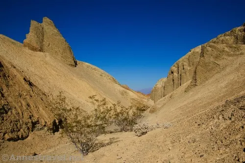
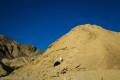
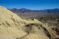
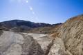
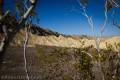
0.0 Unmarked Trailhead where the 20 Mule Team Wash meets the 20 Mule Team Scenic Drive (1,202ft.). Head generally south up the wash. The streambed passes between badland hills and by an old, barred-off borax mine on the right (west) about mile 0.3. Shortly after the mine, the canyon walls begin to rise higher and close in around the wash. (36.391485°, -116.778453°)
0.75 First Dryfall (1,396ft.). The dryfall is fairly easily negotiated by scrambling up the social trail on the left side of the dryfall. (36.3839417°, -116.7826083°)
0.85 Second Dryfall (1,447ft.). The dryfall is fairly easy to scramble up. (36.3828528°, -116.7830111°)
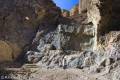
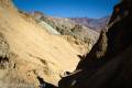
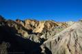
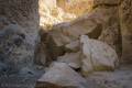
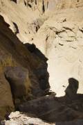
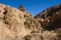
0.95 Third Dryfall (1,498ft.). This is the most difficult of the dryfalls in 20 Mule Team Canyon; I’d call it “sketchy” and you probably don’t want to try climbing it unless you have ample experience scrambling loose rocks and Class 3 to Class 4 slopes. Try climbing straight over the first choke stone, then scramble up the left side of the slide/jumble of boulders. Use caution as much of the left side is loose gravel. Once atop the dryfall, the canyon changes character to yellow/orange walls as it slowly rises toward the height of the hills on either side of the canyon. Keep and eye out for rock formations and occasional side-canyons (mostly on the left/north or east). (36.381869°, -116.782324°)
1.05 Fourth Dryfall (1,593ft.). Again, this one is easy to climb. This is the last major dryfall in the canyon. (36.380746°, -116.781786°)
1.15 Side Canyon on left (1,642ft.). Continue right (southwest at this point) upcanyon. (36.379688°, -116.780999°)
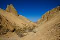
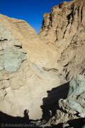
1.3 Side Canyon on left (1,697ft.). Continue right (south) upcanyon. About mile 1.6, the canyon begins to open up in a black-gravel area speckled with occasional mesquite bushes. I recommend staying in the main channel on the left side of the wash. (36.378644°, -116.780128°)
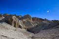
1.9 Top of 20 Mule Team Canyon (1,917ft.). The wash ends on some badlands. You may wish to scramble up the badlands to overlook Corkscrew Canyon. Views extend down Corkscrew Canyon to the Funeral Mountains. Retrace your steps downstream back to the 20 Mule Team Scenic Drive. (36.374142°, -116.775194°)
History & More
The canyon is named for the famous 20 Mule Team that transported borax from Death Valley to the Mojave Rail Depot. Driving 20 mules at one time required great skill.
Most of the “20 Mule Teams” were actually 18 mules and 2 horses.
The first 20 Mule Team wasn’t intended to make history. The foreman asked a teamster if he could haul an extra wagon of borax if he provided eight extra mules for the man’s 12 mule team. The teamster agreed. Marketing eventually got hold of the idea, and the 20 Mule Team became famous.
The route of the 20 Mule Team typically traveled down the east side of Death Valley, past the Greenland Ranch (later known as the Furnace Creek Ranch; now The Ranch at Death Valley), and on toward Wingate Pass across the valley floor. The trip took 20 days round trip.
The 20 Mule Team ran for only six years, after which a narrow-gauge railroad was built. The teams had carried over 20 million tons of borax out of Death Valley.
The area around Jabba the Hutt’s castle was in 20 Mule Team, as was the cave (actually an old borax mine) where Luke Skywalker finishes his lightsaber. I’m not sure, but I think the cave may be in 20 Mule Team Canyon.
Do not enter any of the mine shafts. Not only is it illegal, but it’s also very dangerous.
It’s possible from the top of 20 Mule Team Canyon to descend into Corkscrew Canyon and from there down to CA-190. Do not hike up Corkscrew Canyon, as the area is unmarked private property. The loop is likely about 5 or 5.5 miles.
Download Trail Map
Driving Directions
Take CA-190 to the 20 Mule Team Scenic Drive. The unmarked trailhead is on the left after 1.8 miles.
Remember, it may be easier to climb up dryfalls than down them (or vice versa). Be sure you can climb in the other direction before climbing up or down a dryfall.
Leave No Trace Principles are enforced
Drones and model aircrafts are prohibited
Camping is permitted only in designated sites or in areas open to dispersed backcountry camping
All park rules and regulations
12 Month Pass: $55/Death Valley Annual Pass (valid at Death Valley National Park). $80/America the Beautiful Annual Pass (valid at all national park and federal fee areas). $20/Annual Senior Pass (62 years or older US citizens; valid at all national park and federal fee areas). Free/4th Grade Pass (Valid Sept. 1-August 31 of the child’s 4th Grade school year). Free/Military Pass (valid for all active military personel and their dependents with a CAC Card or DD Form 1173).
Lifetime Pass: $80/Lifetime Senior Pass (62 years or older US citizens; valid at all national park and federal fee areas). Free/Access Pass (available to all US citizens with perminent disabilities). Free/Access for Veterans and Gold Star Families Pass (valid for all military and veterans with a CAC card, Veteran HJealth Identification Card, Veteran ID Card, or veteran’s designation on state-issued drivers license or identification card.)
1 thought on “20 Mule Team Canyon – Death Valley National Park”