Fall Canyon – Death Valley National Park

  Verified Hike
Fall Canyon, Death Valley National Park, California
Views out of Fall Canyon, Death Valley National Park, California
Fall Canyon, Death Valley National Park, California
Hiking up the lower part of Fall Canyon, Death Valley National Park, California
Fall Canyon, Death Valley National Park, California
Side canyon in Fall Canyon, Death Valley National Park, California
Fall Canyon, Death Valley National Park, California
Cliffs in Fall Canyon, Death Valley National Park, California
Fall Canyon narrows, Death Valley National Park, California
Fall Canyon, Death Valley National Park, California
Fall Canyon 1
Fall Canyon
Location of Fall Canyon, Death Valley National Park, California
Fall Canyon 10
Fall Canyon 2
Fall Canyon 11
Fall Canyon 3
Fall Canyon 6
Fall Canyon 4
Fall Canyon 7
Fall Canyon 8
Fall Canyon 9
Fall Canyon 12
Fall Canyon 5
previous arrow
next arrow
Fall Canyon, Death Valley National Park, California
 Fall Canyon, Death Valley National Park, California
Fall Canyon, Death Valley National Park, California
 Fall Canyon, Death Valley National Park, California
Fall Canyon, Death Valley National Park, California
 Fall Canyon, Death Valley National Park, California
Fall Canyon, Death Valley National Park, California
 Fall Canyon, Death Valley National Park, California
 Fall Canyon, Death Valley National Park, California
 Fall Canyon, Death Valley National Park, California
 Fall Canyon, Death Valley National Park, California
 Fall Canyon, Death Valley National Park, California
previous arrow
next arrow

Explore a desert canyon with awesome sheer walls, layered rocks, and a pretty dryfall at the end.

Total Distance: 6.6 miles out & backElevation Gain: 1,839ft. (923ft. to 2,363ft.)
Difficulty: Strenuous5+ Mile Difficulty: Strenuous
View Rating: 4.0 out of 5.0 starsAuthor’s Rating: 5.0 out of 5.0 stars
Visitor Rating:
(Click to rate)
[Total: 0 Average: 0]
Visitor Difficulty Rating:
(Click to rate)
[Total: 0 Average: 0]
Pets: NoHorses: Yes
Best Seasons: November-AprilSpecial Permits: None
Water Availability: NoneOvernight Options: Yes after about 2 miles
Trailhead Amenities: Primitive restroomCrowd Factor: Moderate to Crowded
Trailhead Access: 1.2
Uses: Day hiker icon Backpackers Icon Horses Permitted Icon No Dogs IconTrail Surface: Wash Trail Surface Icon Gravel Trail Surface Icon Dirt Trail Surface Icon Scramble Class 2 Icon
Features: Canyon Trail Feature Icon Colorful Rocks Trail Feature Icon Hazards: Falling Rocks Icon Flash Flood Icon Hot Day Icon Scramble Icon No Water Icon

Mile-by-Mile: Fall Canyon Route

0.0 Fall Canyon Trailhead (933ft.). The trailhead is located behind the primitive restroom. The path begins by rolling along the hillside, then drops into a wash. The old trail continues up the wash, while the new trail turns to cross over another hill and drop into the Fall Canyon Wash further upstream. This and a few social trails will all land you generally in the right place, so don’t worry about taking the exactly right trail as long as it’s heading for the Fall Canyon Wash. (36.8221167°, -117.1740667°)

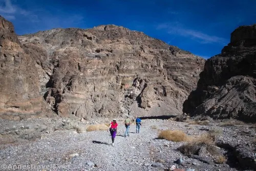
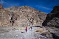
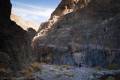
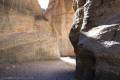
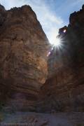
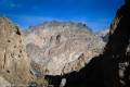
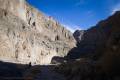
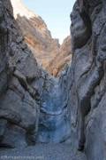
0.75 Fall Canyon Wash (1,186ft.). Drop into the wash, then turn right to almost immediately enter the canyon. Paths traverse most of the canyon, often staying in the middle or near one canyon wall. The walls rise high above the canyon floor in multiple layers and colors. (36.8305167°, -117.1743500°)

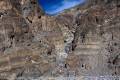
2.1 Side Canyon on left (1,755ft.). Turn left up this canyon for a short distance to a huge double dryfall in a grotto. While it is more or less impassible to ascend from this angle, it’s beautiful enough to warrant the side trek. (36.839836°, -117.159647°)


2.2 Double Dryfall (1,905ft.). Retrace your steps to the main canyon, turn left, and continue upcanyon. (36.840518°, -117.160692°)

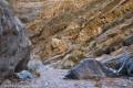
2.9 Canyon Narrows (2,009ft.). Continue upstream. A few small dryfalls are obstacles easy to overcome. (36.8469000°, -117.1548167°)

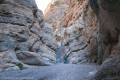
3.4 20ft. Dryfall (2,363ft.). Upward travel ceases here unless you don’t mind a bit of scrambling over sketchy rock to get to the upper canyon (see Upper Fall Canyon). Retrace your steps to your vehicle. (36.845934°, -117.147280°)

History & More

Fall Canyon is very walkable as canyons go. There is little in the way of scrambling until you reach the dryfall where most people turn around.

I’ve heard that Fall Canyon and nearby Titus Canyon are both excellent areas to see bighorn sheep. Sadly, I’ve yet to catch a glimpse of one in the area.

It’s possible to continue beyond the dryfall into Upper Fall Canyon. This requires a sketchy climb up rocks and a loose slope (Class 3+ scramble) – but there are beautiful narrows above the dryfall!

Download Trail Map

Coming soon!

Driving Directions

Take Scotty’s Castle Road to the exit of the Titus Canyon Road (14.9 miles north of CA-190 and 18.3 miles south of the Grapevine Ranger Station). Turn east on the gravel Titus Canyon Road for 2.6 miles to the Titus Canyon Trailhead and Fall Canyon Trailhead parking.

Additional Warnings & RegulationsSpecial Permits & RegulationsFees
Always be wary of flash floods in a canyon.
Remember, it may be easier to climb up dryfalls than down them (or vice versa). Be sure you can climb in the other direction before climbing up or down a dryfall.
Remember to take food & water!
Leave No Trace Principles are enforced
Drones and model aircrafts are prohibited
Camping is permitted only in designated sites or in areas open to dispersed backcountry camping
All park rules and regulations
7 Day Pass: $30/private vehicle. $25/motorcycle. $15/individual (bicycle or on foot).
12 Month Pass: $55/Death Valley Annual Pass (valid at Death Valley National Park). $80/America the Beautiful Annual Pass (valid at all national park and federal fee areas). $20/Annual Senior Pass (62 years or older US citizens; valid at all national park and federal fee areas). Free/4th Grade Pass (Valid Sept. 1-August 31 of the child’s 4th Grade school year). Free/Military Pass (valid for all active military personel and their dependents with a CAC Card or DD Form 1173).
Lifetime Pass: $80/Lifetime Senior Pass (62 years or older US citizens; valid at all national park and federal fee areas). Free/Access Pass (available to all US citizens with perminent disabilities). Free/Access for Veterans and Gold Star Families Pass (valid for all military and veterans with a CAC card, Veteran HJealth Identification Card, Veteran ID Card, or veteran’s designation on state-issued drivers license or identification card.)

Fall Canyon Route

Hiking up the lower reaches of Fall Canyon, Death Valley National Park, California
Hiking up the lower reaches of Fall Canyon

My favorite canyon we did in on our 2020 visit to Death Valley National Park was Fall Canyon in the central part of the park. It even beat out Sidewinder Canyon in my mind, which is saying a lot since Sidewinder Canyon was just too much fun! But Fall Canyon has towering, colorful, beautifully formed walls and easier access, which is probably why I enjoyed it so much.

Narrow twists and turns in Fall Canyon, Death Valley National Park, California
Narrow twists and turns in the lower canyon

The Fall Canyon Trailhead is also the southern trailhead for Titus Canyon. Because of this, it’s very busy with vehicles coming down Titus Canyon, hikers heading up Titus, and hikers heading up Fall Canyon. Parking can be an issue during busy seasons. We took the second-to-last parking spot at about 9am on a Saturday in late fall.

Views to the Cottonwood Mountains from the mouth of Fall Canyon, Death Valley National Park, California
Views to the Cottonwood Mountains from the mouth of Fall Canyon

The trail begins behind the restroom (I feel like I say that a lot… I wonder why so many great trails start behind primitive restrooms?) You do not want to walk up the road into Titus Canyon (beautiful in its own right, but not where we’re hiking in this post). The Fall Canyon Trail travels along the base of the hills to drop into a streambed, then partially follows the streambed and partially follows a trail up and over small hills to drop into the Fall Canyon Wash.

Near the entrance of Fall Canyon, Death Valley National Park, California
Near the entrance of Fall Canyon

There seems to be an old trail that drops into the wash a bit further downstream than the newer trail. Either way, turn right when you drop into the wide wash, and you’ll soon come to where the hills rise out of the valley and the walls of the canyon rise around the wash to form Fall Canyon. I dropped into the wash about mile 0.75 by following the newer trail.

Cliffs and shadows in Fall Canyon, Death Valley National Park, California
Cliffs and shadows in Fall Canyon

Fall Canyon is spectacular almost from the first. The streambed is gravelly with a slight upward slope. It’s not easy hiking, but it’s also not too hard, especially if you stick to the social trails. While you might have to walk around large rocks or other obstacles from time to time, there is no scrambling involved until after the canyon narrows about mile 2.9.

The mouth of the side-canyon off of Fall Canyon, Death Valley National Park, California
The mouth of the sidecanyon

About mile 2.1, a sidecanyon goes off on left. I’ve heard that there is an impressive dryfall a tenth of a mile up the sidecanyon. However, while I saw people exploring the canyon, I did not explore it myself, so I’ll leave that discovery up to you.

Folds and other interesting geological phenomena in Fall Canyon, Death Valley National Park, California
Folds and other interesting geological phenomena

Fall Canyon after the sidecanyon is even more spectacular than before. The layers on the canyon walls take sheer cliffs to a whole new level. Some of the walls are multi-colored. It’s so easy to feel dwarfed here!

Afternoon sun over the canyon walls, Fall Canyon, Death Valley National Park, California
Afternoon sun over the canyon walls

About mile 2.9, the canyon narrows. This is a new side of Fall Canyon. A few short scrambles (Class 2 or mild Class 3) lead upcanyon through this section.

Fall Canyon as it narrows not far from the dryfall, Death Valley National Park, California
Fall Canyon as it narrows

At 3.4 miles from the trailhead, the canyon suddenly ends in a small grotto at a 20ft. dryfall. (I measured the height of the dryfall using my GPS and ended up with 21ft.) It’s sheer and pretty much impassible without technical equipment.

The 20ft. dryfall in Fall Canyon, Death Valley National Park, California
The 20ft. dryfall

This dryfall is where most people end their hike, retracing their steps to the trailhead. Granted, it makes for a fantastic hike.

Approaching the 20 ft. dryfall in Fall Canyon, Death Valley National Park, California
Approaching the 20 ft. dryfall

But if you don’t mind a bit of scrambling (Class 3 bordering on Class 4) there is more to see by hiking up into Upper Fall Canyon.