Corkscrew Peak – Death Valley National Park


Take a very official social trail to a peak in the Grapevine Mountains and great views of Death Valley.
| Total Distance: 7.5 miles out & back | Elevation Gain: 3,284ft. (2,669ft. to 5,784ft.) |
| Difficulty: Very Strenuous | 5-10 Mile Difficulty: Very Strenuous |
| View Rating: 5.0 out of 5.0 stars | Author’s Rating: 3.0 out of 5.0 stars |
| Visitor Rating: (Click to rate) [Total: 0 Average: 0] | Visitor Difficulty Rating: (Click to rate) [Total: 0 Average: 0] |
| Pets: No | Horses: Yes (not recommended) |
| Best Seasons: November-April | Special Permits: None |
| Water Availability: None | Overnight Options: Yes, must be at least 1 mile from the Daylight Pass Road |
| Trailhead Amenities: Primitive Restroom at Hell’s Gate | Crowd Factor: Solitude |
| Trailhead Access: 0.6 | |
| Uses: | Trail Surface: |
| Features: | Hazards: |
Mile-by-Mile: Corkscrew Peak
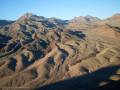
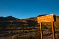
0.0 Daylight Pass Road (2,689ft.). From the small pulloff next to the sign pointing toward Corkscrew Peak, you have a choice. Most people follow the very vague and sometimes cairned social trails that head generally toward Corkscrew Peak, which is visible to the north. This guide heads due west until it drops into a large wash. (Most of the trails arrive at the large wash sooner or later, this guide chooses to get there sooner.) (36.738900°, -116.968240°)
0.4 Large wash (2,730ft.). Turn right (north) up the very wide wash. Looking back, you can see out to Death Valley and Telescope Peak. (36.738596°, -116.975529°)
1.6 Wash narrows (3,259ft.). The wash narrows significantly while a larger wash enters from the right. Continue up the narrowing wash as it heads north and a bit west into the Grapevine Mountains. (36.755751°, -116.978396°)
1.9 Exit Wash (3,358ft.). Turn left (west) to exit the wash via a breach in the canyon wall. It should be well-cairned. From here, a trail leads generally northward up toward Corkscrew Peak, often following the ridgeline. The last 0.3 miles before the summit is the steepest and most difficult part of the hike – keep your eyes open for a rock arch known as “Hole in the Rock.” (36.759265°, -116.980939°)
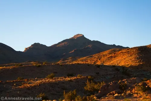
3.75 Corkscrew Peak (5,784ft.). Enjoy spectacular views across Death Valley and the surrounding mountains. (36.770648°, -117.004145°)
History & More
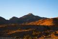
Views are spectacular from Corkscrew Peak. To the south is Death Valley (the humpy hills close to the peak are the Death Valley Buttes) with the Panamint Range to the right of the valley (the highest point is Telescope Peak, although other mountains, including Aguerberry Point and Wildrose Peak, should also be visible). Continuing to the right are Tucky Mountain and Pinto Peak and then the Mesquite Sand Dunes in the valley. In the distance to the west are Mt. Whitney and surrounding mountains, with the Cottonwood Mountains closer to you. More northerly in the Grapevine Mountains, you should be able to see Mount Palmer, Thimble Peak (stripy), Grapevine Peak, and Wahguyhe Peak. Eastern views are into Nevada, with the Funeral Mountains to the southwest to the left of Death Valley.
Early explorers of Death Valley found wild grapevines growing in the mountains and gave the range its name.
The tallest peak in the Grapevine Mountains is (not surprisingly) Grapevine Peak, reaching heights of 8,738ft.
Some adventurers opt to not turn up Corkscrew Peak after 1.9 miles and instead continue up the canyon. Minor scrambles pose easy-to-overcome obstacles for a fun day exploring a canyon in the Grapevine Mountains.
Download Trail Map
Coming soon!
Driving Directions
Take the Daylight Pass Road (signed for Beatty) from Scotty’s Castle Road. At 6.7 miles, bear left to stay on the Daylight Pass Road. About 1.2 miles later, park in the pulloff on the left side of the road with a sign pointing toward Corkscrew Peak. The trailhead is also 4.9 miles south of Daylight Pass.
Camping in a canyon is discouraged due to the danger of flash floods.
Remember, it may be easier to climb up dryfalls than down them (or vice versa). Be sure you can climb in the other direction before climbing up or down a dryfall.
Camping is not allowed within one mile of a paved road, developed area, or dirt road that is closed to camping.
Camping is not permitted within 100 feet of a flowing stream, spring, or other natural body of open water.
No camping is permitted on the floor of Death Valley, within one mile of Darwin Falls and Greenwater Canyon, on the active/shifting sand dunes, and certain other canyons and backcountry areas.
Camping is also prohibited within one mile of the Ubehebe Lead Mine, Leadfield Mines, Keane Wonder Mill, and Skidoo Mill.
Camping is limited to 30 days per calendar year within the park.
Fires are permitted in NPS-provided fire grates or grills ONLY.
Leave No Trace Principles are enforced
Drones and model aircrafts are prohibited
Camping is permitted only in designated sites or in areas open to dispersed backcountry camping
All park rules and regulations
12 Month Pass: $55/Death Valley Annual Pass (valid at Death Valley National Park). $80/America the Beautiful Annual Pass (valid at all national park and federal fee areas). $20/Annual Senior Pass (62 years or older US citizens; valid at all national park and federal fee areas). Free/4th Grade Pass (Valid Sept. 1-August 31 of the child’s 4th Grade school year). Free/Military Pass (valid for all active military personel and their dependents with a CAC Card or DD Form 1173).
Lifetime Pass: $80/Lifetime Senior Pass (62 years or older US citizens; valid at all national park and federal fee areas). Free/Access Pass (available to all US citizens with perminent disabilities). Free/Access for Veterans and Gold Star Families Pass (valid for all military and veterans with a CAC card, Veteran HJealth Identification Card, Veteran ID Card, or veteran’s designation on state-issued drivers license or identification card.)
1 thought on “Corkscrew Peak – Death Valley National Park”