Chloride City Road – Death Valley National Park


Rough dirt road to the site of Chloride City, one of the earliest mining areas in Death Valley.
| Total Distance: 7.5 miles point to point (dead end) | Elevation Gain: 2,357ft. up, 498ft. down (3,412ft. to 5,275ft.) |
| Road Difficulty: 2.5 (1.7 for the first 2.2 miles to the Monarch Canyon Spur Road) | Bicycle Difficulty: Very Difficult |
| View Rating: 5.0 out of 5.0 stars | Author’s Rating: 3.0 out of 5.0 stars |
| Visitor Rating: (Click to rate) [Total: 0 Average: 0] | Visitor Difficulty Rating: (Click to rate) [Total: 0 Average: 0] |
| Pets: Leashed | Horses: Yes |
| Best Seasons: October-May | Special Permits: None |
| Water Availability: None | Overnight Options: Dispersed camping permitted after 2 mile |
| Amenities: None | Crowd Factor: Solitude to Moderate |
| Uses: | Road surface: |
| Features: | Hazards: |
Mile-by-Mile: Chloride City Road
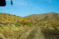
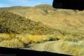
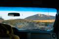
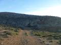
0.0 Chloride City Road on the Daylight Pass Road (3,412ft.). The road is marked by a sign saying that 4×4 is required. Take the rough dirt road northeast and then east up into the mountains. The road is often narrow and bordered by brush. (36.750608°, -116.936689°)
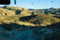
2.2 Monarch Canyon Road Junction (3,513ft.). Continue left on the Chloride City Road. The road becomes rougher after this junction, with technical sections that may require skillful 4×4 driving. (36.736708°, -116.912581°)
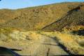
4.5 Enter wash (4,190ft.). Continue straight (east) on the main road as it follows the wash. (36.717990°, -116.896552°)
4.7 Spur road on right (south) (4,229ft.). Continue straight (east) on the main road up the wash. (36.717344°, -116.893983°)
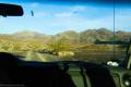
5.2 Chloride Cliffs Road Junction (4,364ft.). Turn right to access Chloride City and Chloride Cliffs. (The left (straight) road leads out to US-95 in Nevada and is the Chloride Cliffs Road.) Beyond the junction, the road is very steep, rocky, and may require technical 4×4 experience. (36.717760°, -116.885228°)
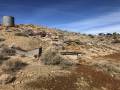
6.25 Spur road on right (southwest) (4,761ft.). The road on right leads to an old water tank and prospects. Continue straight (east) on the main road. (36.707050°, -116.885286°)
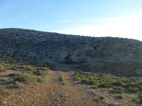
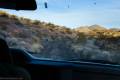
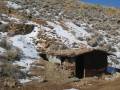
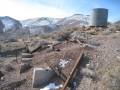
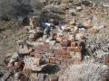
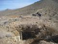
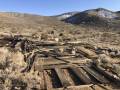
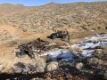
6.5 Chloride City Site (4,729ft.). A few buildings, a grave, and many prospects are all that remain of the once-bustling mine site. Roads seem to fork in all directions; you want to head southeast. Most people seem to stop at the townsite, so the road is less used as it heads for the Chloride Cliffs. (36.704854°, -116.882731°)
6.6 Spur road on right (west) (4,776ft.). Continue left (southeast). (The right road leads to old buildings and prospects, which may be of interest.) The spur reconnects to the main road a tenth of a mile beyond the junction. (36.703546°, -116.881761°)
7.0 Five-way junction (5,038ft.). The two right (west) spurs lead to prospects. The straight and left (south and east) roads connect after a bit, so you can take whichever road seems better to you. This guide goes straight (south). The road passes a few spur roads, prospects, and ruins. (36.699441°, -116.878785°)
7.2 Spur road on left (east) (5,141ft.). The spur road (the left/east spur in the last section) reconnects here. Continue straight (southwest) on the main road. (36.697749°, -116.876829°)
7.3 Spur rod on left (south) (5,161ft.). Continue straight (right/west) on the main road. (36.696927°, -116.877678°)
7.35 Road split (5,169ft.). The road splits west and southwest; take the left road southwest. (The right road leads down some steep switchbacks to some old prospects.) (36.696823°, -116.878822°)
7.5 Chloride Cliffs Viewpoint (5,275ft.). Views are phenomenal to Badwater, the Panamint Range (including Telescope Peak), and the Amargosa Range. (36.694861°, -116.880042°)
History & More
The first mine in Death Valley was worked on Chloride Cliff, near today’s Chloride City. In 1871, A. J. Franklin discovered a vein of chloride of silver while surveying the Nevada-California border for the U. S. Government. Mr. Franklin immediately filed seven claims on the property and began work on the site. Every three months, a mule train would travel across the trailless desert to take the ore to market – San Bernandino, about 180 miles away – and return with supplies. While the transportation proved too difficult and expensive to make the strike profitable, Franklin’s explorations of the best routes across the desert would pave the way for future ore strikes.
In 1904, the Bullfrog gold strike suddenly brought interest – and better transportation – to the Funeral Mountains. A. J. Franklin and his son, George E. Franklin, had taken annual trips to the claims on Chloride Cliff, so George still held the rights to the claims. He continued to work the mines on his own as other mining companies and prospectors swarmed the vicinity.
Chloride City was founded in 1905 during the Bullfrog gold strike. Snow inhibited work in the winter, but local mining companies constructed a mill and piped water down from Keane Spring. Within a year, it was a ghost town, the prospectors having moved on to more promising claims.
George Franklin continued to work his own claims until the San Francisco Fire devastated the possibilities of investments. He sold out for $150,000 to a group in Pittsburgh, Pennsylvania. The mines in the area were slowly consolidated into a single group, and work finally resumed in 1909. Work was sporadic on the mines in the area through the 1960s, but only a riddled smattering of audits, dugouts, ruined cabins, mills, and other debris remain.
Just south of Chloride City is the grave of James McKay. No one knows who McKay was, when he died, or what the cause of death was. Some have called it “The Tomb of the Unknown Miner.”
The viewpoint at the end of the Chloride City Road is on top of an old mine dump. From the viewpoint you can look down about 5,000ft. on Death Valley.
Download Trail Map
Coming soon!
Driving Directions
Take the Daylight Pass Road (signed for Beatty) from Scotty’s Castle Road. At 6.7 miles, bear left to stay on the Daylight Pass Road. Keep climbing another 3.4 miles to the dirt road signed for 4×4 High Clearance, No Camping Next 2 Miles. The road is also 2.8 miles south of Daylight Pass (about 16 miles southeast of Beatty).
It is extremely dangerous to enter a mine due to unstable shafts, gasses, and more. Do not enter mines, even if they are apparently open!
Walking on, climbing, entering, ascending, descending, or traversing any mine, structure, feature, or ruin is prohibited.
Toxic chemicals or ore may be present around mine sites. Enter at your own risk.
Possessing, destroying, injuring, defacing, removing, digging, or disturbing any mine, structure, feature, or ruin is also prohibited.
Leave No Trace Principles are enforced
Drones and model aircrafts are prohibited
Camping is permitted only in designated sites or in areas open to dispersed backcountry camping
All park rules and regulations
12 Month Pass: $55/Death Valley Annual Pass (valid at Death Valley National Park). $80/America the Beautiful Annual Pass (valid at all national park and federal fee areas). $20/Annual Senior Pass (62 years or older US citizens; valid at all national park and federal fee areas). Free/4th Grade Pass (Valid Sept. 1-August 31 of the child’s 4th Grade school year). Free/Military Pass (valid for all active military personel and their dependents with a CAC Card or DD Form 1173).
Lifetime Pass: $80/Lifetime Senior Pass (62 years or older US citizens; valid at all national park and federal fee areas). Free/Access Pass (available to all US citizens with perminent disabilities). Free/Access for Veterans and Gold Star Families Pass (valid for all military and veterans with a CAC card, Veteran HJealth Identification Card, Veteran ID Card, or veteran’s designation on state-issued drivers license or identification card.)
5 thoughts on “Chloride City Road – Death Valley National Park”