Death Valley Buttes – Death Valley National Park

  Verified Hike
  This is a Rumored Hike. Wayfinding may be required or the route or features may not exist. Travel at your own risk and always obey signs and local regulations.
Corkscrew Peak from the Death Valley Buttes, Death Valley National Park, California
Hiking back from the Death Valley Buttes, Death Valley National Park, California
The Funeral Mountains from the Death Valley Buttes, Death Valley National Park, California
Daylight Pass Road from the Death Valley Buttes, Death Valley National Park, California
Social Trail up the Death Valley Buttes, Death Valley National Park, California
The Funeral Mountains from the Death Valley Buttes, Death Valley National Park, California
Badwater Flats from the Death Valley Buttes, Death Valley National Park, California
Climbing down the Death Valley Buttes, Death Valley National Park, California
Sunlight over the Death Valley Buttes, Death Valley National Park, California
Corkscrew Peak from the Death Valley Buttes, Death Valley National Park, California
Late afternoon on the Death Valley Buttes, Death Valley National Park, California
Walking down from the Death Valley Buttes, Death Valley National Park, California
Death Valley Buttes 1
Death Valley Buttes
Map Death Valley - Hell's Gate, Death Valley Buttes, Daylight Pass Road, Etc.

Photo credit David Whiting, All Rights Reserved

Death Valley Buttes 2

Photo credit David Whiting, All Rights Rserved

Death Valley Buttes 3

Photo credit Micah Whiting, All Rights Reserved

Death Valley Buttes 4

Photo credit Micah Whiting, All Rights Rserved

Death Valley Buttes 5

Photo credit Micah Whiting, All Rights Reserved

Death Valley Buttes 6

Photo credit Micah Whiting, All Rights Reserved

Death Valley Buttes 12

Photo credit David Whiting, All Rights Reserved

Death Valley Buttes 7

Photo credit David Whiting, All Rights Reserved

Death Valley Buttes 8

Photo credit David Whiting, All Rights Reserved

Death Valley Buttes 9

Photo credit Micah Whiting, All Rights Reserved

Death Valley Buttes 10

Photo credit David Whiting, All Rights Reserved

Death Valley Buttes 11

Photo credit David Whiting, All Rights Reserved

previous arrow
next arrow
Corkscrew Peak from the Death Valley Buttes, Death Valley National Park, California
Hiking back from the Death Valley Buttes, Death Valley National Park, California
The Funeral Mountains from the Death Valley Buttes, Death Valley National Park, California
Daylight Pass Road from the Death Valley Buttes, Death Valley National Park, California
Social Trail up the Death Valley Buttes, Death Valley National Park, California
The Funeral Mountains from the Death Valley Buttes, Death Valley National Park, California
Badwater Flats from the Death Valley Buttes, Death Valley National Park, California
Climbing down the Death Valley Buttes, Death Valley National Park, California
Sunlight over the Death Valley Buttes, Death Valley National Park, California
Corkscrew Peak from the Death Valley Buttes, Death Valley National Park, California
Late afternoon on the Death Valley Buttes, Death Valley National Park, California
Walking down from the Death Valley Buttes, Death Valley National Park, California
previous arrow
next arrow

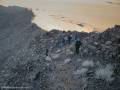
Follow a social trail up the Death Valley Buttes via Class 2-Class 4 scrambles to and through beautiful views of Death Valley and nearby mountains.

Total Distance: 1.6-3.2 miles out & backElevation Gain: 1,669ft. (2,078ft. to 3,008ft.)
Difficulty: Moderately Strenuous0-5 Mile Difficulty: Very Strenuous
View Rating: 4.0 out of 5.0 starsAuthor’s Rating: 3.0 out of 5.0 stars
Visitor Rating:
(Click to rate)
[Total: 0 Average: 0]
Visitor Difficulty Rating:
(Click to rate)
[Total: 0 Average: 0]
Pets: NoHorses: Yes (not recommended)
Best Seasons: November-AprilSpecial Permits: None
Water Availability: NoneOvernight Options: None
Trailhead Amenities: Primitive Restroom at Hell’s GateCrowd Factor: Solitude
Trailhead Access: 0.6
Uses: Day hiker icon Horses Permitted Icon No Dogs IconTrail Surface: Dirt Trail Surface Icon Scramble Class 4 Icon Off Trail Surface Icon
Features: Views Trail Feature IconHazards: Hot Day Icon Scramble Class 4 Icon No Water Icon Vague Trail Hazard Icon

Mile-by-Mile: Death Valley Buttes

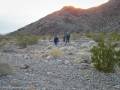
0.0 Daylight Pass Road at the north end of the Death Valley Buttes (2,103ft.). Walk toward the north end of the Death Valley Buttes, heading for a defined social trail on the north side of the butte. Note that a second social trail route leads up a ravine slightly to the left (east). The two meet after a short distance, so either is a viable option. (If you can’t safely park along the road, park up at the information kiosk at Hells Gate and walk back down the road or cross-country to the Death Valley Buttes. This will add about 0.4 miles each way to your mileage.) (36.718472°, -116.979868°)

0.2 Social Trail (2,089ft.). Follow the trail up the side of the butte. The trail reaches the ridgeline and immediately drops into a saddle where the trail from the wash meets the trail from the north. (36.717524°, -116.982977°)

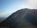
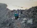
0.3 Saddle (2,227ft.). Continue to follow the social trail – it is loose and slippery for a short way – along the south side of the butte, across another small saddle, and then along the north side of the butte. The route eventually runs straight up the ridgeline – watch your step, as you definitely don’t want to fall here – scrambling over occasional rocks to the first summit. (36.717161°, -116.984810°)

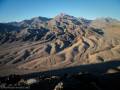
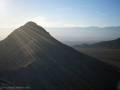
0.8 First Summit (2,732ft). Views are spectacular here to the Death Valley Wilderness and to the west and south. If you do not want a Class 4 scramble with exposure, turn around here and retrace your steps to your vehicle for a 1.6 mile out & back hike (the view doesn’t improve much beyond this, so you won’t have missed much). For more adventures, continue on the social trail down the narrow ridge and across the north slope and down into a saddle. (36.715517°, -116.992628°)

1.0 Second Saddle (2,486ft.). An alternate route back leaves shortly after this, dropping down off the north slope. The social trail to the true summit continues along the north side of the ridge to a third saddle. (36.714345°, -116.994827°)

1.3 Third Saddle (2,618ft.). From here, the route is a rocky scramble up the summit cliffs. There are Class 3 and Class 4 sections of scramble, a knife-edge ridge, and a 6in. ledge that must be navigated. Stay as close as possible to the rest of the ridge for the easiest hiking. (36.713147°, -116.999843°)

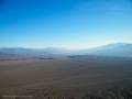
1.6 Summit Cairn/Red Top BM (3,005ft.). Enjoy spectacular views to the west, south, and northwest before retracing your steps to your vehicle. (36.711456°, -117.004598°)

History & More

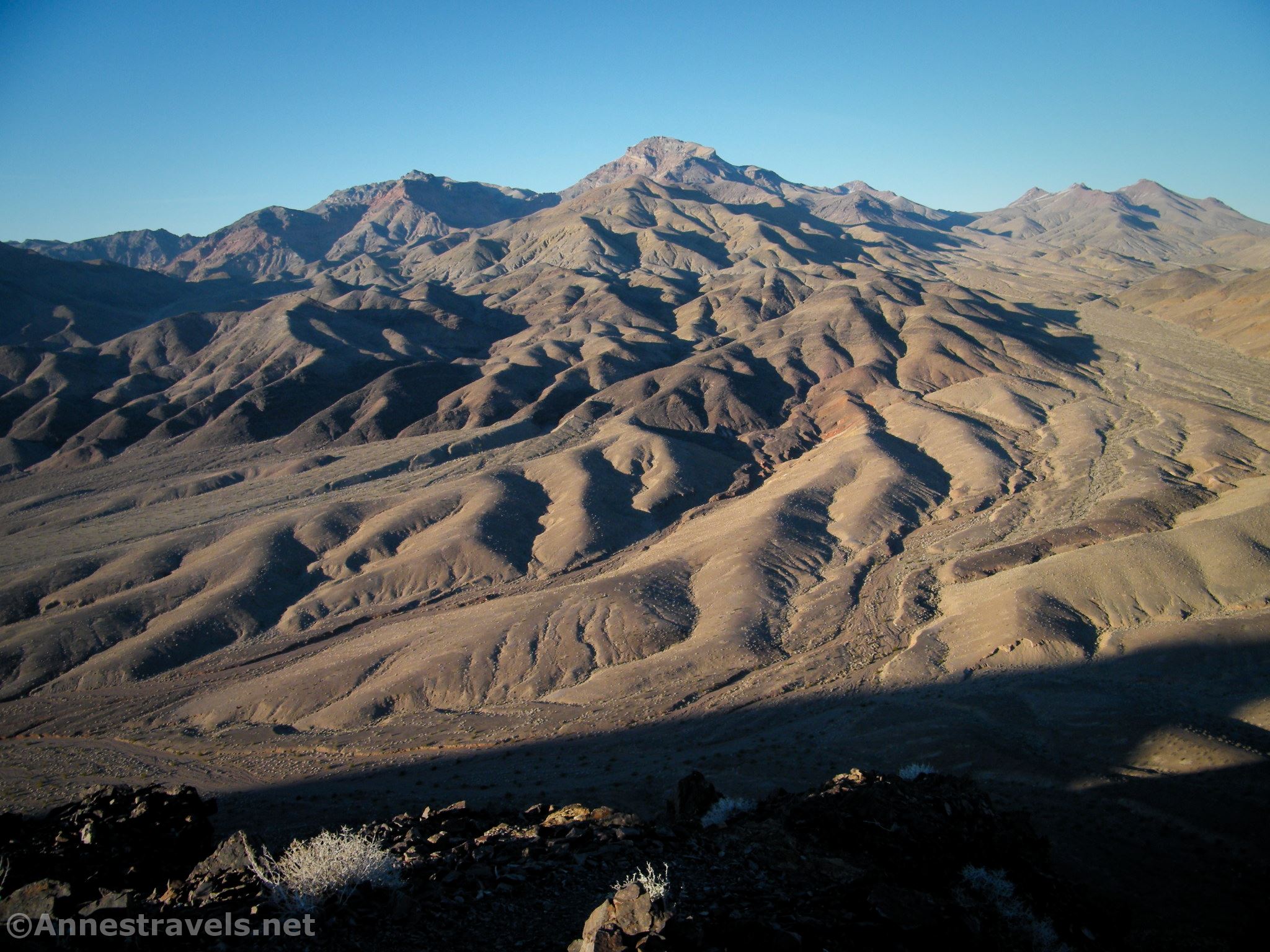
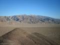
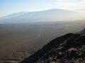
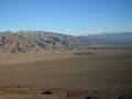
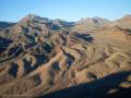
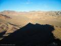
Views are spectacular from the Death Valley Buttes. To the north is Corksrew Peak and the Grapevine Mountains. Eastward is Boundary Canyon and Daylight Pass. To the south, enjoy views of Badwater and Death Valley between the Funeral Mountains (left) and Panamint Mountains (right). Looking west, you can see the Mesquite Sand Dunes and Mesquite Flat below the Cottonwood Mountains.

Download Trail Map

Driving Directions

Take the Daylight Pass Road (signed for Beatty) from Scotty’s Castle Road. After 6.3 miles, park along the side of the road (do it safely – if you can’t safely park, then continue another 0.4 miles up to parking area at the road junction).

Special Permits & RegulationsFees
Remember to take food & water!
Leave No Trace Principles are enforced
Drones and model aircrafts are prohibited
Camping is permitted only in designated sites or in areas open to dispersed backcountry camping
Click here for all park rules and regulations
7 Day Pass: $30/private vehicle. $25/motorcycle. $15/individual (bicycle or on foot).
12 Month Pass: $55/Death Valley Annual Pass (valid at Death Valley National Park). $80/America the Beautiful Annual Pass (valid at all national park and federal fee areas). $20/Annual Senior Pass (62 years or older US citizens; valid at all national park and federal fee areas). Free/4th Grade Pass (Valid Sept. 1-August 31 of the child’s 4th Grade school year). Free/Military Pass (valid for all active military personel and their dependents with a CAC Card or DD Form 1173).
Lifetime Pass: $80/Lifetime Senior Pass (62 years or older US citizens; valid at all national park and federal fee areas). Free/Access Pass (available to all US citizens with perminent disabilities). Free/Access for Veterans and Gold Star Families Pass (valid for all military and veterans with a CAC card, Veteran HJealth Identification Card, Veteran ID Card, or veteran’s designation on state-issued drivers license or identification card.)

Exploring the Death Valley Buttes

Corkscrew Peak from the Death Valley Buttes, Death Valley National Park, California
Corkscrew Peak from the Death Valley Buttes. PC David Whiting, All Rights Reserved

One December afternoon in Death Valley, we were bored. It’s hard to imagine being bored in Death Valley, but we’d already done our favorite official hikes, including Badwater Flats that morning. We read in the park literature that the Death Valley Buttes could be climbed, and since we were in the area, why not check out something new?

The Daylight Pass Road and Mud Canyon from the Death Valley Buttes, Death Valley National Park, California
The Daylight Pass Road and Mud Canyon from the Death Valley Buttes. PC Micah Whiting, All Rights Reserved

The other great thing about exploring the Death Valley Buttes, we decided, was that it would give my baby brothers a chance at a nap while the rest of us went to find the social trail. Have you ever tried to climb over car seats without waking the babies in said car seats? I finally decided that scrambling over the back of the driver’s seat was probably a safer option since I was on one of the bench seats in the back of the van and had to get out somehow.

Hiking back from the Death Valley Buttes, Death Valley National Park, California
Hiking back from the Death Valley Buttes. PC David Whiting, All Rights Reserved

We set out from the sign kiosk at Hell’s Gate, working our way south. It’s not hard to know which way to go; there’s only one great bulk of a mountain between the Daylight Pass Road and the Grapevine Mountains. (If you can park along the Daylight Pass Road, you can cut up to half a mile each way off of your hike – but only if you can safely park along the road. It’s legal to park along the roads in the national park as long as you’re off the road.)

You can see the social trail winding just below the ridgeline on the Death Valley Buttes, Death Valley National Park, California
You can see the social trail winding just below the ridgeline. PC Micah Whiting, All Rights Reserved

Once we reached the north end of the buttes, we picked up the social trail. It’s not groomed or even entirely stable, but there’s no missing it, either. The trail usually follows the ridgeline, though sometimes it drops below the ridgeline along the side of the butte, especially on the northwest side.

The social trail winding up the northwest side of the Death Valley Buttes, Death Valley National Park, California
The social trail winding up the northwest side of the butte. PC Micah Whiting, All Rights Reserved

The first summit is 0.6 miles from where you started up the side of the butte. The views are spectacular down Death Valley from here. Badwater is very visible, and it’s also so neat to see the Funeral Mountains (including toward the Keane Wonder Mine) on the left (east of Death Valley) and Panamint Mountains (including Telescope Peak) to the right (west) of the valley.

Views toward Badwater Flats from the Death Valley Buttes, Death Valley National Park, California
Views toward Badwater. PC David Whiting, All Rights Reserved

But that’s not all the views. Keep turning right (west) to see the Mesquite Sand Dunes and the Cottonwood Mountains beyond. Turning to the north are the Grapevine Mountains – Corkscrew Peak is especially nice. With views like this, it’s hard to decide where to look first!

Corkscrew Peak (left) and the Grapevine Mountains from the Death Valley Buttes, Death Valley National Park, California
Corkscrew Peak (left) and the Grapevine Mountains. PC Micah Whiting, All Rights Reserved

As I recall (that was 13 years ago and before I started writing about our adventures), we didn’t get too far beyond the first peak. Daylight was fading, and we did want to get back to our mom, who had stayed back with the babies.

Long shadows of evening with views to Daylight Pass from the Death Valley Buttes, Death Valley National Park, California
Long shadows of evening. PC David Whiting, All Rights Reserved

But the social trail continues along the ridgeline to the second (and higher) peak of the Death Valley Buttes. I hear there are some fun scrambles along the way, even a six-inch ledge to shimmy along. Still, I can’t imagine the views being that different from what you’ve already seen (except perhaps better views of the Mesquite Sand Dunes).

Hiking back down the social trail from the Death Valley Buttes, Death Valley National Park, California
Hiking back down the social trail. PC David Whiting, All Rights Reserved.

If you decide to keep going as far as you can, it’s about 0.8 miles further to the second summit. The trail undulates with the terrain with a few scramble sections (up to a Class 4). You’ll also pass an alternate exit route on the north side of the butte that would allow you to scramble back down to the plain and then walk around the butte to get back to the parking area.

The sun over the tallest of the Death Valley Buttes, Death Valley National Park, California
The sun over the tallest of the Death Valley Buttes. PC Micah Whiting, All Rights Reserved

Whether you decide to keep hiking or not, enjoy the views before hiking back down to where you parked your vehicle.

The Funeral Mountains from the Death Valley Buttes, Death Valley National Park, California
The Funeral Mountains from the Death Valley Buttes. PC Micah Whiting, All Rights Reserved