
Daylight Pass Road – Death Valley National Park


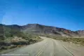

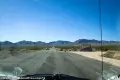
A scenic paved road between the main roads of Death Valley and Beatty, Nevada. The road climbs up from the Scotty’s Castle Road, over Daylight Pass between the Funeral Mountains and the Grapevine Mountains, and then across the plains to US-95.
| Total Distance: 26.0 miles point to point | Elevation Gain: 4,445ft. up, 1,314ft. down (166ft. to 4,215ft.) |
| Road Difficulty: 0.6 | Bicycle Difficulty: Easy |
| View Rating: 4.0 out of 5.0 stars | Rating: 4.0 out of 5.0 stars |
| Visitor Rating: (Click to rate) [Total: 0 Average: 0] | Visitor Difficulty Rating: (Click to rate) [Total: 0 Average: 0] |
| Pets: Leashed | Horses: No |
| Best Seasons: October-May | Special Permits: None |
| Water Availability: Water is available in Beatty; no water is available along this route in Death Valley National Park | Overnight Options: None outside of Beatty |
| Amenities: Occasional primitive toilets at trailheads; water and services in Furnace Creek | Crowd Factor: Crowded |
| Uses: | Road surface: |
| Features: | Hazards: |
Mile-by-Mile: Daylight Pass Road (Scotty’s Castle Road to Beatty, NV)
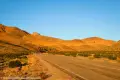
0.0 Scotty’s Castle Road Junction with Daylight Pass Road (166ft.). Turn onto the Daylight Pass Road to travel northeast (a sign will point toward Beatty, NV with no mention of the road’s name). After a little over half a mile, the road enters Mud Canyon (causing some to call this part of the route Mud Canyon Road). The “canyon” is a wash through the low, gravelly hills that allows the road access up toward Daylight Pass. The road exits the upper end of the canyon about mile 3.0. Continue upward with the Death Valley Buttes directly to the west. (36.646364°, -117.041404°)
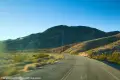
6.7 Hell’s Gate/Beatty Cutoff Road Junction (2,274ft.). The Beatty Cutoff Road is to the right (south/east). On the west side of the road at the junction is an information kiosk with a primitive restroom and a picnic table. Continue straight (north) on the Daylight Pass Road, passing a service road on the right (east) about mile 7.2. At this point, you’re climbing up to Daylight Pass with the Funeral Mountains on your right (east) and the Grapevine Mountains on your left (west) as the road ascends through Boundary Canyon. (36.723856°, -116.977926°)
10.0 Chloride City Road on right (east) (3,412ft.). The rough dirt road leads to one of the oldest mining districts in Death Valley. Continue straight on the paved road. (36.750608°, -116.936689°)
12.9 Daylight Pass (4,315ft.). Near here, the famous “Old Dinah” steam engine burst her boiler. She was later transported down to the Furnace Creek Ranch. It’s (mostly) all downhill from here! (36.788750°, -116.931669°)
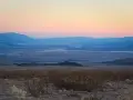
13.2 California/Nevada State Line (4,208ft.). Continue east on the Daylight Pass Road. The road may be called Death Valley Road or NV-374 after this. The road exits the mountains about mile 16.4 to travel across a broad plain. (36.792559°, -116.928201°)
17.2 Death Valley National Park Border (3,549ft.). The sign announcing the park and a pulloff are nearby. Continue on the Daylight Pass Road. (36.832354°, -116.880246°)
19.9 Titus Canyon Road on left (west) (3,416ft.). The Titus Canyon Road is a favorite for jeepers and motorcyclists, although it’s rated for high clearance 2WD vehicles in dry conditions. Traffic is one-way driving from north (here) to south (Scotty’s Castle Road) passing through the Grapevine Mountains, past an old mining camp, and through the narrows of a canyon. Continue on Daylight Pass Road. (36.859137°, -116.845884°)
22.0 Rhyolite Road on left (west) (3,365ft.). Continue straight toward Beatty on the Daylight Pass Road. As you come into Beatty, you will cross several sidestreets. (36.880863°, -116.818013°)
26.0 US-95 on right and straight (3,302ft.). US-95 takes a hard turn here – so the junction looks like a four-way intersection. Right (southeast) is US-95; straight (northeast) is US-95; and left (northwest) is North Second Street. (36.908421°, -116.759326°)
History & More
Beatty, Nevada, is popular from the standpoint that it’s the closest semblance of civilization to the main part of Death Valley National Park. Most people drive out here to get gas and other supplies, combining it with a trip to Rhyolite and/or the Titus Canyon Road.
In 1910, J.R. Lane purchased an ancient traction engine from the Tonopah & Tidewater Railroad and converted it to road use with the intent of carrying supplies across the desert. Early tests of “Old Dinah” were promising, pulling twenty tons of supplies in her four trailers, plus a tanker wagon of water. However, prior to J.R. Lane’s ventures, Old Dinah had broken down on her very first trip, and was towed back to town by mules. Still, Mr. Lane convinced the Porter Brothers in Rheyolite, Nevada, that his tractor was more efficient than the brothers’ mules and horses for carrying supplies to the Keane Wonder Mine. The traction engine made several trips to and from the Keane Wonder Mine, carrying supplies for the workers.
Still, Old Dinah wasn’t exactly a silver bullet. She required four men to keep her running – a fireman, an engineer, a brakeman, and a mechanic. The last man’s job was to work all night long, every single night, fixing and maintaining the engine, so that she’d run the next day.
Only a few weeks after beginning operations, Old Dinah’s boiler burst en route over Daylight Pass. J.R. Lane furiously blamed over-used machinery and poor-quality water. Old Dinah was left right where she sat, waiting for J.R. Lane to bring a gasoline-powered engine to replace the boiler, while the mules took over transporting goods once again. In 1932, two employees of the Pacific Coast Borax Company brought Old Dinah down to the Furnace Creek Ranch, where she still sits today.
Download Road Map
Coming soon!
Trailhead Location
Southern Terminus: Scotty’s Castle Road, 0.6 miles north of where the Scotty’s Castle Road touches CA-190 east of Stovepipe Wells.
Northern Terminus: Beatty, Nevada along US-95.
Driving Directions
From Furnace Creek, take CA-190 North toward Stovepipe Wells. After 17.1 miles, turn right onto Scotty’s Castle Road, following the signs for Scotty’s Castle. (This junction is 7.2 miles south (really east) of Stovepipe Wells on CA-190.) After 0.6 miles, you’ll come to the Daylight Pass Road, on the right, signed for Beatty, Nevada.
From Las Vegas, take US-95 north for 116 miles to the town of Beatty. At the stop sign, turn left following the sign for Rhyolite, Death Valley, and NV-374.
Leave No Trace Principles are enforced
Drones and model aircrafts are prohibited
Camping is permitted only in designated sites or in areas open to dispersed backcountry camping
Click here for all park rules and regulations
12 Month Pass: $55/Death Valley Annual Pass (valid at Death Valley National Park). $80/America the Beautiful Annual Pass (valid at all national park and federal fee areas). $20/Annual Senior Pass (62 years or older US citizens; valid at all national park and federal fee areas). Free/4th Grade Pass (Valid Sept. 1-August 31 of the child’s 4th Grade school year). Free/Military Pass (valid for all active military personel and their dependents with a CAC Card or DD Form 1173).
Lifetime Pass: $80/Lifetime Senior Pass (62 years or older US citizens; valid at all national park and federal fee areas). Free/Access Pass (available to all US citizens with perminent disabilities). Free/Access for Veterans and Gold Star Families Pass (valid for all military and veterans with a CAC card, Veteran HJealth Identification Card, Veteran ID Card, or veteran’s designation on state-issued drivers license or identification card.)
18 thoughts on “Daylight Pass Road – Death Valley National Park”