Corridor Canyon to Saline Valley – Death Valley National Park


From the end of The Corridor, Corridor Canyon continues down to empty into Saline Valley. A couple of easy dryfalls and one Class 4 scramble (or ropes) are required, although most of the canyon is wide and easy to walk.
| Total Distance: 12.5 miles point-to-point or 14.8 miles out & back | Elevation Gain: 1,090ft. gain, 3,644ft. descent or 3,784ft. total gain (3,860ft. to 1,090ft. or 2,058ft.) |
| Difficulty: Strenuous to Very Extremely Strenuous | 10+ Mile Difficulty: Strenuous to Extremely Strenuous |
| View Rating: 4.0 out of 5.0 stars | Author’s Rating: 4.0 out of 5.0 stars |
| Visitor Rating: (Click to rate) [Total: 0 Average: 0] | Visitor Difficulty Rating: (Click to rate) [Total: 0 Average: 0] |
| Pets: No | Horses: Yes (though it would be difficult to get horses up and down the dryfalls) |
| Best Seasons: November-April | Special Permits: None |
| Water Availability: None | Overnight Options: Dispersed camping permitted at least a mile outside of the Racetrack Valley |
| Trailhead Amenities: None | Crowd Factor: Solitude |
| Trailhead Access: 2.3 (or 1.9 if you walk in from the Racetrack Road) | |
| Uses: | Trail Surface: |
| Features: | Hazards: |
Mile-by-Mile: Corridor Canyon to Saline Valley
0.0 Ubehebe Lead Mine Parking Area (3,860ft.). Follow the directions down to the end of The Corridor in Corridor Canyon. (36.749246°, -117.585270°)
4.2 End of the Corridor (2,890ft.). The canyon doubles back on itself at this point. Keep walking down several small rock “dryfalls.” (36.739708°, -117.615712°)
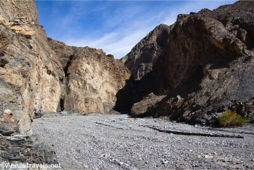
4.5 Enter Fourth Narrows (2,803ft.). Walk about a tenth of a mile to the next dryfall, which looks very slick but can be reascended by “walking” up with your feet on either wall of the canyon. On the way down, it’s a great slide! The canyon after this is never again especially narrow. Two or three small (up to 4ft.) dryfalls are easy to negotiate. Beyond this, the canyon is a wide, gravelly slog. (36.7426580°, -117.6177840°)
5.75 Impassible dryfall (2,513ft.). The 30ft. dryfall is both sheer and undercut – there is no way to get down it without ropes. This is the turnaround point for casual hiking (as if what you’ve done before this is “casual!”). If you don’t mind some sketchy scrambling, there is a bypass. Backtrack a short distance until you’re out of the alcove just above the dryfall. On the left (while going upcanyon) is another alcove where the canyon is narrowing for the dryfall. Here you’ll find a social path leading up to the top of the wall of powdery rock. (36.734451°, -117.630374°)
5.8 Begin bypass (2,501ft.). Once at the top of the cliff walls, follow the cairns right as they head almost due north (and a slight bit west) to the top of a watercourse, crossing a wash along the way. While the ground underfoot is pebbly, it’s flat enough not to pose much danger. (36.734776°, -117.630307°)
5.9 Top of watercourse (2,605ft.). Descending into the tiny watercourse is not easy. The ground is extremely steep and dangerously slippery with tiny rocks. If you feel safe doing it, drop into the watercourse, turn left, and follow its tumbling, crumbling course down into a medium-size sidewash (36.735484°, -117.631280°). Turn left to walk down to the main canyon. (36.7362610°, -117.6306750°)
6.0 Reenter main canyon (2,425ft.). Turn right to continue downcanyon. Breathe a sigh of relief – it’s clear sailing from here through a wide canyon, some moderately wide narrows about mile 6.9, more wide canyon, and finally out the mouth of Corridor Canyon. (36.734817°, -117.631495°)
7.4 Mouth of Corridor Canyon (2,058ft.). The wash is wide by this point and continues to be wide as the walls drop around the wash and the wash heads toward the plains. Once at the plains, head due south and a bit west to reach the Saline Valley Road – you may or may not see evidence of an old road along the way. (36.720941°, -117.646368°)
12.5 Saline Valley Road (1,306ft.). Your exact meeting place with the road may vary, but this is one coordinate near an old “Borrow Pit” and BM 1325.6, as well as a small parking area. (36.662372°, -117.691481°)
History & More
I was the first person I’ve ever heard of hiking all the way from the Corridor to Saline Valley. That said, I did find social trails and cairns, and the route shows up on GoogleEarth – so someone must have done it before me!
For the most part, the hike below the Corridor is a dull, wide canyon hike without much excitement. Save your view-junkie eyes for after exiting the canyon – the views into Saline Valley, and especially back toward the Last Chance Range, are gorgeous!
The hillside in the drainage on the bypass is so steep, and the ground so slippery with small stones, that I can’t really recommend it. In fact, my companion and I waffled back and forth on whether we wanted to attempt it for at least five minutes and finally decided that one of us would stand at the top while the other would climb down and then back up without using our climbing rope (the person at the top had the rope just in case the scrambler couldn’t get back up). If we could both get down and up without the rope, we would both move forward. It was tricky and sketchy, and I was very thankful for hiking poles, but we made it… without having to use the rope!
I did this as a single-day hike, so I had to return to the Racetrack Road before dark (I made it – barely). So instead of going all of the way down to the Saline Valley Road, I climbed a hillside on the left, maybe a quarter or half a mile below the canyon mouth. The views from here were amazing.
While horses are technically allowed on this route, they should start at the Saline Valley Road, as the dryfalls are too steep/slick to be navigated by most pack animals.
Download Route Map
Coming soon!
Driving Directions
Take the Racetrack Road from the Ubehebe Crater Road 21.7 miles from the crater. Turn right onto the unmarked dirt road heading west – otherwise known as the Ubehebe Lead Mine Road. Drive 0.75 miles to the end of the road and park near the ruins. The end of the road is deeply rutted, so if you don’t have a rugged 4×4 vehicle, you may wish to park at the top of the pass and walk down to the mine area.
It is extremely dangerous to enter a mine due to unstable shafts, gasses, and more. Do not enter mines, even if they are apparently open!
Walking on, climbing, entering, ascending, descending, or traversing any mine, structure, feature, or ruin is prohibited.
Toxic chemicals or ore may be present around mine sites. Enter at your own risk.
Possessing, destroying, injuring, defacing, removing, digging, or disturbing any mine, structure, feature, or ruin is also prohibited.
Always be wary of flash floods in a canyon.
Camping in a canyon is discouraged due to the danger of flash floods.
Remember, it may be easier to climb up dryfalls than down them (or vice versa). Be sure you can climb in the other direction before climbing up or down a dryfall.
Camping is not allowed within one mile of a paved road, developed area, or dirt road that is closed to camping.
Camping is not permitted within 100 feet of a flowing stream, spring, or other natural body of open water.
No camping is permitted on the floor of Death Valley, within one mile of Darwin Falls and Greenwater Canyon, on the active/shifting sand dunes, and certain other canyons and backcountry areas.
Camping is also prohibited within one mile of the Ubehebe Lead Mine, Leadfield Mines, Keane Wonder Mill, and Skidoo Mill.
Camping is limited to 30 days per calendar year within the park.
Fires are permitted in NPS-provided fire grates or grills ONLY.
Leave No Trace Principles are enforced
Drones and model aircrafts are prohibited
Camping is permitted only in designated sites or in areas open to dispersed backcountry camping
All park rules and regulations
12 Month Pass: $55/Death Valley Annual Pass (valid at Death Valley National Park). $80/America the Beautiful Annual Pass (valid at all national park and federal fee areas). $20/Annual Senior Pass (62 years or older US citizens; valid at all national park and federal fee areas). Free/4th Grade Pass (Valid Sept. 1-August 31 of the child’s 4th Grade school year). Free/Military Pass (valid for all active military personel and their dependents with a CAC Card or DD Form 1173).
Lifetime Pass: $80/Lifetime Senior Pass (62 years or older US citizens; valid at all national park and federal fee areas). Free/Access Pass (available to all US citizens with perminent disabilities). Free/Access for Veterans and Gold Star Families Pass (valid for all military and veterans with a CAC card, Veteran HJealth Identification Card, Veteran ID Card, or veteran’s designation on state-issued drivers license or identification card.)