Gower Gulch – Death Valley National Park


Photo credit J Whiting, All Rights Reserved
H ike and scramble up a desert canyon. The Gower Gulch route is usually combined with the Badlands Loop and Golden Canyon for a loop option.
| Total Distance: 6.4 miles out & back | Elevation Gain: 1,094ft. (-186ft. to 590ft.) |
| Difficulty: Moderately Strenuous | 5-10 Mile Difficulty: Moderately Strenuous |
| View Rating: 2.0 out of 5.0 stars | Author’s Rating: 2.0 out of 5.0 stars |
| Visitor Rating: (Click to rate) [Total: 0 Average: 0] | Visitor Difficulty Rating: (Click to rate) [Total: 0 Average: 0] |
| Pets: No | Horses: No |
| Best Seasons: November-April | Special Permits: None |
| Water Availability: None | Overnight Options: None |
| Trailhead Amenities: Primitive Restroom | Crowd Factor: Moderate |
| Trailhead Access: 0.6 | |
| Uses: | Trail Surface: |
| Features: | Hazards: |
Mile-by-Mile: Gower Gulch Trail
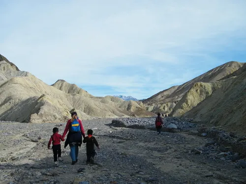
0.0 Gower Gulch Trailhead (-148ft.). The trailhead is near the restroom for Golden Canyon Trailhead. Follow the trail south along the base of the mountains (if you find yourself immediately in a canyon, you’re on the wrong trail). (36.420508°, -116.846661°)
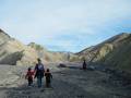
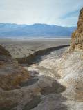
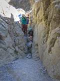
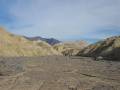
0.75 Gower Gulch (-135ft.). Turn left (west) up Gower Gulch – fairly quickly, you’ll come to a very large dryfall, but the trail will take you up to the top. At times, small dryfalls will need to be scrambled (Class 2 to Class 3). As the badland walls close in around Gower Gulch, views fade. Much of the trail is simply walking up the wash between badland walls. (36.411062°, -116.841623°)
2.0 Wash split (270ft.). Take the left (main) fork. (36.416701°, -116.827247°)
2.1 Badlands Loop Junction #1 (289ft.). Both the Gower Gulch route and the Badlands Loop continue straight (east) up Gower Gulch – the Badlands Loop also turns left (north). (36.416727°, -116.825743°)
2.9 Badlands Loop Junction #2 (483ft.). The Badlands Loop turns left (north) here – for a loop option, turn left here and then immediately turn left to follow the Badlands Loop down to the Golden Canyon Trail. To continue up Gower Gulch, keep walking straight (east) up the gulch. (36.419433°, -116.815539°)
3.2 More or Less Head of Gower Gulch (590ft.). It may be possible to scramble north or east up through the badlands up to the Zabriskie Point Parking Area. (36.419938°, -116.810410°)
History & More
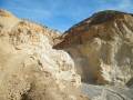
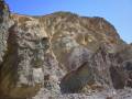
Many of the yellow-tinted rocks in Death Valley have a high concentration of Limonite, a type of iron ore. The purple and red/orange rocks have hematite in them, and green or blue rock is comprised of chlorite or nontronite.
Gower Gulch is probably named after a street corner in Hollywood. In the 1930s, cowboys would loiter on the street corner, waiting to be hired by movie studios as extras in Western Films. In 1940, a cowboy extra had a real duel with another extra – he was arrested for homicide, but his fellow cowboy extras testified in his favor. The other extra was mean, they said, and “somebody had to shoot him.” The trial was, according to a bystander, “dizzier than a blindfolded bronc being sack-broke with a new slicker.” The trial was dismissed without a sentence.
Download Trail Map
Driving Directions
From Furnace Creek, take CA-190 East for 1.3 miles. Turn right on the Badwater Road; the Golden Canyon Trailhead will be on the left after 2.0 miles.
From Death Valley Junction, take CA-190 West 28.9 miles to the Badwater Road. Turn left, following the sign for Badwater. The Golden Canyon Trailhead will be on the left after 2.0 miles.
Remember, it may be easier to climb up dryfalls than down them (or vice versa). Be sure you can climb in the other direction before climbing up or down a dryfall.
Leave No Trace Principles are enforced
Drones and model aircrafts are prohibited
Camping is permitted only in designated sites or in areas open to dispersed backcountry camping
All park rules and regulations
12 Month Pass: $55/Death Valley Annual Pass (valid at Death Valley National Park). $80/America the Beautiful Annual Pass (valid at all national park and federal fee areas). $20/Annual Senior Pass (62 years or older US citizens; valid at all national park and federal fee areas). Free/4th Grade Pass (Valid Sept. 1-August 31 of the child’s 4th Grade school year). Free/Military Pass (valid for all active military personel and their dependents with a CAC Card or DD Form 1173).
Lifetime Pass: $80/Lifetime Senior Pass (62 years or older US citizens; valid at all national park and federal fee areas). Free/Access Pass (available to all US citizens with perminent disabilities). Free/Access for Veterans and Gold Star Families Pass (valid for all military and veterans with a CAC card, Veteran HJealth Identification Card, Veteran ID Card, or veteran’s designation on state-issued drivers license or identification card.)
2 thoughts on “Gower Gulch – Death Valley National Park”