Badlands Loop – Death Valley National Park


Photo credit J Whiting, All Rights Reserved
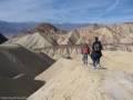
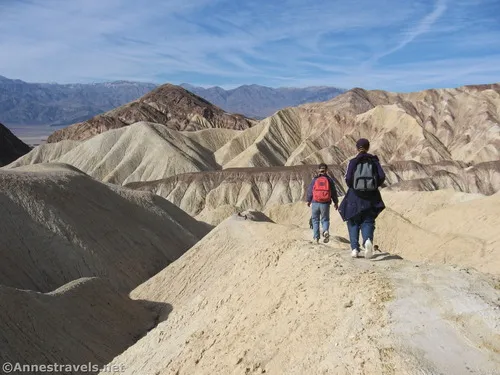
T ravel a trail in the badlands below Zabriskie Point. The trail is often used as a loop option and to access the Golden Canyon/Gower Gulch trail system.
| Total Distance: 2.7 mile lollipop loop | Elevation Gain: 542ft. (650ft. to 289ft.) |
| Difficulty: Moderate | 0-5 Mile Difficulty: Moderately Strenuous |
| View Rating: 3.0 out of 5.0 stars | Author’s Rating: 3.0 out of 5.0 stars |
| Visitor Rating: (Click to rate) [Total: 0 Average: 0] | Visitor Difficulty Rating: (Click to rate) [Total: 0 Average: 0] |
| Pets: No | Horses: No |
| Best Seasons: Morning in November-April | Special Permits: None |
| Water Availability: None | Overnight Options: None |
| Trailhead Amenities: Primitive Restroom | Crowd Factor: Crowded |
| Trailhead Access: 0.6 | |
| Uses: | Trail Surface: |
| Features: | Hazards: |
Mile-by-Mile: Badlands Trail
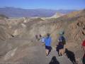
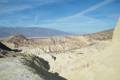
0.0 Zabriskie Point Trailhead (650ft.). Instead of following the paved path up the hill to Zabriskie Point, turn right to hike north on the gravel path. The trail will turn west into the badlands to work its way downward. Enjoy the views from the trail. (36.420784°, -116.810197°)
0.5 Trail Junction (487ft.). This is the point where the loop begins. This guide turns right to work its way over and around many badland hills. (36.419640°, -116.815615°)
1.1 Golden Canyon Trail Junction (357ft.). Turn left down the wash to continue on the Badlands Loop. (36.419260°, -116.822438°)
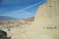
1.4 Gower Gulch (289ft.). Turn left to continue on the Badlands Loop. The route winds up Gower Gulch between the badlands. (36.416728°, -116.825755°)
2.2 Turn left (483ft.). Turn left up the side wash – the trail will reconnect to the trail up to the Zabriskie Point Parking Area after a few feet. Continue straight (up the wash at this point) to return to the parking area. (36.419434°, -116.815536°)
2.7 Zabriskie Point Trailhead (650ft.). (36.420784°, -116.810197°)
History & More
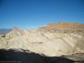
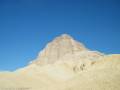
The pointy monolith standing up from the badlands is Manly Beacon. It was named for William Manly, a local miner and hero. At the age of 29, Manly moved from his native state of Vermont to fill his thirst for gold fever as one of the ‘49ers. He tried to float the Green River to the Colorado River, but eventually native guides took him and the others with him overland. He then set out with other families and ‘49ers to cross Death Valley. The group became stranded, so Manly and another traveler, John Haney Rogers (of Roger’s Peak), walked 250 miles across the Mojave Desert almost to Los Angeles to find a route out. The two were able to buy supplies and return to lead the party to safety.
The term “badlands” was created by the Lakota people who settled near the White River tributary of the Missouri River. It was adopted French Canadian fur traders who noted how difficult the area was to travel through. “Les mauvaises terres” became “bad lands” in English.
Badlands are found on every continent except Antarctica.
Download Trail Map
Driving Directions
From Furnace Creek, take CA-190 East 4.8 miles to the Zabriskie Point Parking Area, on the right 3.5 miles east of Badwater Junction.
From Death Valley Junction, take CA-190 West 25.4 miles to the Zabriskie Point Parking Area, on the left.
Camping in a canyon is discouraged due to the danger of flash floods.
Remember, it may be easier to climb up dryfalls than down them (or vice versa). Be sure you can climb in the other direction before climbing up or down a dryfall.
Leave No Trace Principles are enforced
Drones and model aircrafts are prohibited
Camping is permitted only in designated sites or in areas open to dispersed backcountry camping
All park rules and regulations
12 Month Pass: $55/Death Valley Annual Pass (valid at Death Valley National Park). $80/America the Beautiful Annual Pass (valid at all national park and federal fee areas). $20/Annual Senior Pass (62 years or older US citizens; valid at all national park and federal fee areas). Free/4th Grade Pass (Valid Sept. 1-August 31 of the child’s 4th Grade school year). Free/Military Pass (valid for all active military personel and their dependents with a CAC Card or DD Form 1173).
Lifetime Pass: $80/Lifetime Senior Pass (62 years or older US citizens; valid at all national park and federal fee areas). Free/Access Pass (available to all US citizens with perminent disabilities). Free/Access for Veterans and Gold Star Families Pass (valid for all military and veterans with a CAC card, Veteran HJealth Identification Card, Veteran ID Card, or veteran’s designation on state-issued drivers license or identification card.)
4 thoughts on “Badlands Loop – Death Valley National Park”