Lippincott Mine (Lead King Mine) – Death Valley National Park


Visit an old mine along with views of Saline Valley.
| Total Distance: 2.5 mile loop with spurs | Elevation Gain: 611ft. (3,732ft. to 4,014ft.) |
| Difficulty: Moderate | 0-5 Mile Difficulty: Moderately Strenuous |
| View Rating: 4.0 out of 5.0 stars | Author’s Rating: 3.0 out of 5.0 stars |
| Visitor Rating: (Click to rate) [Total: 0 Average: 0] | Visitor Difficulty Rating: (Click to rate) [Total: 0 Average: 0] |
| Pets: No | Horses: Yes |
| Best Seasons: November-April | Special Permits: None |
| Water Availability: None | Overnight Options: The Homestake Dry Camp is located near the trailhead |
| Trailhead Amenities: Primitive campground | Crowd Factor: Solitude |
| Trailhead Access: 1.9 | |
| Uses: | Trail Surface: |
| Features: | Hazards: |
Mile-by-Mile: Lippincott Mine
0.0 Road to the Lippincott Mine (Lead King Mine) at the Homestake Dry Camp at the end of the Racetrack Road (3,764ft.). Follow the old road south – while it’s possible for experienced 4×4 vehicles to drive the road, it is rough and dangerous enough that most people hike it. (36.6368946°, -117.5744040°)
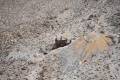
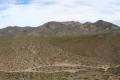
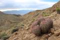
0.4 Road split (3,872ft.). An old water truck is nearby. Both forks are worth pursuing, so this hike turns left (south) to complete the two roads as a loop. Views from this road are excellent down into Saline Valley and to the High Sierras beyond. Also, keep your eyes open for old mining relics, including an old vehicle and the remains of the top of a tramway. The road winds south and then turns northwest up to the old mine. (36.632127°, -117.574839°)
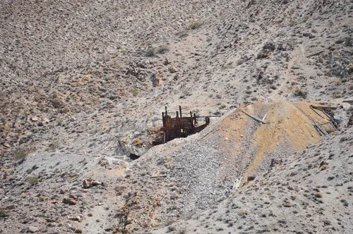
0.9 Lead King Mine/Lippincott Mine (3,993ft.). The road continues a short distance up to more mines and mining relics, including ore car tracks, metal headgear, ore hoppers, an inclined hoist, and more. From here, if you want to complete the roads as a loop, retrace your steps to the old car; a little beyond this, a watercourse (36.6312480°, -117.5778190°) will take you down the hillside to the lower road. The route is steep, so watch your step (you can also retrace your steps to the road split and explore the second road from there – it’s a much easier route!). (36.632397°, -117.579938°)
1.4 Meet the northern road (3,748ft.). This is the right fork you didn’t take back at the “Road split.” Turn left (west) to continue up to the end of the road. (36.634295°, -117.580097°)
1.5 End of road (3,758ft.). Explore (carefully!) the old mining relics; there are also mines (do not enter, as they are not very stable). After exploring, turn around and take the road back toward the Homestake Dry Camp. (36.634521°, -117.581499°)
2.1 Return to road split (3,872ft.). The old water truck is nearby. Turn left (north) to return to the trailhead. (36.632127°, -117.574839°)
2.5 Homestake Dry Camp Road (3,764ft.). (36.6368946°, -117.5744040°)
History & More
The Lead King Mine (Lippincott Mine) began development in May of 1942. Lead was mined by eight men and trucked to Goldfield. From there, the railroad carried it to smelters in Utah. The difficulty in transportation required the men only to ship the best silver-lead ore to turn a profit – the silver was used in the construction of storage batteries during the Second World War. However, operations were briefly shut down during WWII as the US government used the area for aerial gun practice. In the early 1950s, a smelter was built in Santa Ana, California, specifically for the Lead King Mine and nearby ore deposits. About 1,000 tons of ore was mined from the main tunnel before the operation ceased in the mid-1950s.
Do not enter any of the mine shafts. Not only is it illegal, but it’s also very dangerous.
Lead was mined in this area. Chances are that the tailings and dirt still contain lead. Try not to breathe the dust or disturb any of the soil any more than absolutely necessary.
Download Trail Map
Coming soon!
Driving Directions
Take the Racetrack Road from the Ubehebe Crater Road 29.4 miles from the crater to the Homestake Dry Camp. Park near the far end of the camp and follow the road up toward the mine.
It is extremely dangerous to enter a mine due to unstable shafts, gasses, and more. Do not enter mines, even if they are apparently open!
Walking on, climbing, entering, ascending, descending, or traversing any mine, structure, feature, or ruin is prohibited.
Toxic chemicals or ore may be present around mine sites. Enter at your own risk.
Possessing, destroying, injuring, defacing, removing, digging, or disturbing any mine, structure, feature, or ruin is also prohibited.
Leave No Trace Principles are enforced
Drones and model aircrafts are prohibited
Camping is permitted only in designated sites or in areas open to dispersed backcountry camping
All park rules and regulations
12 Month Pass: $55/Death Valley Annual Pass (valid at Death Valley National Park). $80/America the Beautiful Annual Pass (valid at all national park and federal fee areas). $20/Annual Senior Pass (62 years or older US citizens; valid at all national park and federal fee areas). Free/4th Grade Pass (Valid Sept. 1-August 31 of the child’s 4th Grade school year). Free/Military Pass (valid for all active military personel and their dependents with a CAC Card or DD Form 1173).
Lifetime Pass: $80/Lifetime Senior Pass (62 years or older US citizens; valid at all national park and federal fee areas). Free/Access Pass (available to all US citizens with perminent disabilities). Free/Access for Veterans and Gold Star Families Pass (valid for all military and veterans with a CAC card, Veteran HJealth Identification Card, Veteran ID Card, or veteran’s designation on state-issued drivers license or identification card.)