Red Wall Canyon – Death Valley National Park


Red Wall Canyon (north of Little Arches Canyon) is the third-most-popular canyon in the Grapevine Mountains (after Titus Canyon and Fall Canyon). It features gorgeous red walls, slots, and some serious scrambles.
| Total Distance: 15.8 miles out & back | Elevation Gain: 6,040ft. (396ft. to 4,660ft.) |
| Difficulty: Easy | 10+ Mile Difficulty: Easy |
| View Rating: 4.0 out of 5.0 stars | Author’s Rating: 3.0 out of 5.0 stars |
| Visitor Rating: (Click to rate) [Total: 0 Average: 0] | Visitor Difficulty Rating: (Click to rate) [Total: 0 Average: 0] |
| Pets: No | Horses: Yes, but a horse couldn’t get beyond the chokestone |
| Best Seasons: November-April | Special Permits: None |
| Water Availability: None | Overnight Options: Dispersed camping permitted at least 1 mile from Fall Canyon and 1 mile from the North Highway |
| Trailhead Amenities: None | Crowd Factor: Solitude |
| Trailhead Access: 0.6 | |
| Uses: | Trail Surface: |
| Features: | Hazards: |
Mile-by-Mile: Red Wall Canyon
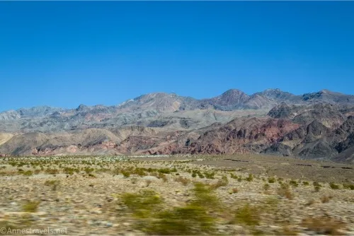
0.0 Unmarked trailhead on the North Highway (Scotty’s Castle Road) (396ft.). Hike north and a little east toward the mouth of Red Wall Canyon. The terrain is generally rocky, gravelly, and soft with prickly plants. If you can, scramble up onto a higher area next to the alluvial fan/wash with firmer footing. (36.836465°, -117.226598°)
2.2 Mouth of Red Wall Canyon (1,428ft.). Walk up the canyon that quickly narrows with amazingly red walls. (36.862257°, -117.207811°)
2.6 First Narrows (1,674ft.). There are many interesting rocks in this area. (36.862384°, -117.200400°)
3.0 Dryfall & chokestone (2,073ft.). This 25ft. dryfall with a chokestone above is a formidable obstacle, though exactly how hard it is to climb depends on your scrambling skills. Often, a rope is installed to aid with climbing, though this can be dangerous if the rope is frayed or decomposing, and you often need to climb a bit before you can reach the rope, anyway. Instead of climbing, I’ll tell you how to take a (still difficult, but not impossible) bypass. Walk back downcanyon 0.3 miles (almost out of the first narrows) to a scree slope just to the left of a large outcrop of rock on the east (left when coming downcanyon) side of the canyon. (36.865431°, -117.198401°)
3.4 Beginning of the Talus Jack Bypass (1,688ft.). Begin climbing the scree slope. It is steep, loose, and not much fun; try to stay right and use the many large boulders to keep you from slipping or sliding on loose rocks. As you near the top, two saddles with a triangular peak in between will come into view – go to the right (south) saddle. The final 50 or 75ft. has very few boulders, so it is especially slippery. (36.862723°, -117.200158°)
3.6 Saddle (2,171ft.). Views are very good from the saddle, so enjoy them before dropping northward down a small sidecanyon – this is an easier descent with plenty of good footholds and handholds. The first part of the descent is very steep; heading right allows for a slightly more gradual drop into the sidecanyon. In the sidecanyon, drop north (left) to get back into Red Wall Canyon. A small dryfall at the end may look tricky but is actually quite easy to slide down (and climb back up if you decide to bypass on the way back downcanyon). (36.864284°, -117.197717°)
3.75 Drop into Red Wall Canyon (2066ft.). Turn left if you wish to see the top of the chokestone before continuing upcanyon. There is a short but spectacular section of narrows before the canyon widens. (36.865354°, -117.197900°)
4.3 Second Narrows (2,509ft.). These are less spectacular than the first narrows, but they’re still pretty amazing. They also contain the famous “slickenside” of Red Wall Canyon – a wall that reminds me of Utah with its desert varnish, only white and red instead of black. A second dryfall also poses an interesting scramble, though it’s not too difficult (especially compared to the chokestone). (36.869735°, -117.191786°)
5.0 End of Second Narrows (2,765ft.). The canyon begins to widen. About 0.15 miles upstream, a sidecanyon on the right (southeast; 36.872858°, -117.181635°) can be explored, though it ends fairly quickly at a dryfall. (36.871901°, -117.183132°)
5.4 Third Narrows (3,008ft.). These narrows are less impressive than the first two, but the upper portion has a fantastic view of Mount Palmer. (36.874548°, -117.178119°)
6.1 End of Third Narrows (3,432ft.). The canyon widens for a bit before entering the fourth narrows. (36.879110°, -117.170101°)
7.1 Fourth Narrows (4,134ft.). Again, these are not as spectacular as the lowest two narrows, but they appear to be interesting to see. (36.890081°, -117.158718°)
7.9 End of Fourth Narrows (4,660ft.). Most people have turned around by this point, although you can continue hiking upcanyon if you wish. (36.897572°, -117.153584°)
History & More
Ropes are often installed by previous hikers to help with bypassing the first chokestone. If you choose to use these, use extreme care to make sure they are safe – you wouldn’t want one to break on you.
The bypass is named for its founder, “Talus” Jack Lumberman.
Much of the bypass is a rock scramble over small boulders. Use extreme caution, both for your own safety and so that you don’t push down a rock on an unsuspecting hiker below.
It is possible to return via the Talus Jack Bypass if you wish, though I hear it’s not too hard to go back down the chokestone dryfall.
Most people turn around after (or before) the end of the Third Narrows.
Other hikers say that the lower narrows (before the chokestone) are so spectacular, the hike is worth the effort just to see them. Of course, there are more amazing things to see if you can bypass the chokestone.
Download Route Map
Coming soon!
Driving Directions
Take Scotty’s Castle Road north from CA-190 to just before (just south of) mile marker 19. This is 14.4 miles south of the Grapevine Ranger Station.
Camping in a canyon is discouraged due to the danger of flash floods.
Remember, it may be easier to climb up dryfalls than down them (or vice versa). Be sure you can climb in the other direction before climbing up or down a dryfall.
Camping is not allowed within one mile of a paved road, developed area, or dirt road that is closed to camping.
Camping is not permitted within 100 feet of a flowing stream, spring, or other natural body of open water.
No camping is permitted on the floor of Death Valley, within one mile of Darwin Falls and Greenwater Canyon, on the active/shifting sand dunes, and certain other canyons and backcountry areas.
Camping is also prohibited within one mile of the Ubehebe Lead Mine, Leadfield Mines, Keane Wonder Mill, and Skidoo Mill.
Camping is limited to 30 days per calendar year within the park.
Fires are permitted in NPS-provided fire grates or grills ONLY.
Leave No Trace Principles are enforced
Drones and model aircrafts are prohibited
Camping is permitted only in designated sites or in areas open to dispersed backcountry camping
All park rules and regulations
12 Month Pass: $55/Death Valley Annual Pass (valid at Death Valley National Park). $80/America the Beautiful Annual Pass (valid at all national park and federal fee areas). $20/Annual Senior Pass (62 years or older US citizens; valid at all national park and federal fee areas). Free/4th Grade Pass (Valid Sept. 1-August 31 of the child’s 4th Grade school year). Free/Military Pass (valid for all active military personel and their dependents with a CAC Card or DD Form 1173).
Lifetime Pass: $80/Lifetime Senior Pass (62 years or older US citizens; valid at all national park and federal fee areas). Free/Access Pass (available to all US citizens with perminent disabilities). Free/Access for Veterans and Gold Star Families Pass (valid for all military and veterans with a CAC card, Veteran HJealth Identification Card, Veteran ID Card, or veteran’s designation on state-issued drivers license or identification card.)