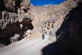
Titus Canyon Narrows – Death Valley National Park


Hike the road through the Titus Canyon Narrows to interesting rock walls, a spring, rock art, and more.
| Total Distance: Up to 15.6 miles out & back | Elevation Gain: Up to 4,419ft. (928ft. to 3,745ft.) |
| Difficulty: Easy to Easy | 5+ Mile Difficulty: Easy to Easy |
| View Rating: 4.0 out of 5.0 stars | Author’s Rating: 3.0 out of 5.0 stars |
| Visitor Rating: (Click to rate) [Total: 0 Average: 0] | Visitor Difficulty Rating: (Click to rate) [Total: 0 Average: 0] |
| Pets: No | Horses: Yes |
| Best Seasons: November-April | Special Permits: None |
| Water Availability: No potable water | Overnight Options: None |
| Trailhead Amenities: Primitive restroom | Crowd Factor: Moderate to Crowded |
| Trailhead Access: 1.2 | |
| Uses: | Trail Surface: |
| Features: | Hazards: |
Mile-by-Mile: Titus Canyon Narrows
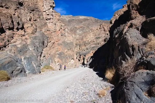
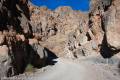
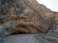
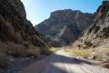
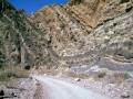
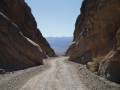
0.0 Exit of Titus Canyon Narrows (930ft.). Walk on the gravel road up the canyon. Be wary of vehicles coming down the canyon toward you, especially in the afternoon. The road winds through the tight canyon for about 1.7 miles before beginning to widen. (36.822044°, -117.173873°)
4.5 End of Lower Narrows (2,606ft.). This is as far as most people hike. However, you can continue to other interesting features if you want. (36.828135°, -117.109666°)
5.9 Klare Spring (3,076ft.). The spring area is an excellent place to view wildlife, especially bighorn sheep. (36.840990°, -117.090998°)
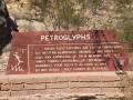
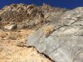
5.95 Petroglyph Rock (3,083ft.). Petroglyphs on a boulder have been badly vandalized, but you can still see the shapes of animals, desert plants, and more. (36.841196°, -117.090654°)
7.8 Road exits Titus Canyon (3,745ft.). From here, you can continue into Upper Titus Canyon or retrace your steps to the parking area at the mouth of the canyon. (36.853169°, -117.066764°)
History & More
Keep a wary eye out for vehicles driving down the canyon. Most drivers are cautious and courteous, but you should still be careful. For the fewest vehicles, hike early in the morning, as there hasn’t been time for the vehicles to drive down from the beginning of the road yet.
You can hike as far or as little up Titus Canyon as you desire. There are things to see within a quarter mile or even 7+ miles up the canyon.
The Timbisha American Indians carved petroglyphs into the rocks near Klare Spring. These prehistoric carvings depict desert animals, geometric designs, and more.
Titus Canyon is one of the best places in Death Valley to spot desert bighorn sheep. However, the sheep are masters of disguise – almost invisible when standing still. Watch for movements of white (the sheep’s rump).
Titus Canyon was named for Morris Titus. In 1906, Morris and several other prospectors left Rhyolite to seek their fortunes in the Grapevine Mountains. While camped in Titus Canyon, water supplies ran low. Morris left for help and more supplies, but his fate is unknown. What we do know is that he did not return to the camp or to Rhyolite.
Download Trail Map
Coming soon!
Driving Directions
Take Scotty’s Castle Road to the exit of the Titus Canyon Road (14.9 miles north of CA-190 and 18.3 miles south of the Grapevine Ranger Station). Turn east on the gravel Titus Canyon Road for 2.6 miles to the Titus Canyon Trailhead and Fall Canyon Trailhead parking.
Remember, it may be easier to climb up dryfalls than down them (or vice versa). Be sure you can climb in the other direction before climbing up or down a dryfall.
Leave No Trace Principles are enforced
Drones and model aircrafts are prohibited
Camping is permitted only in designated sites or in areas open to dispersed backcountry camping
All park rules and regulations
12 Month Pass: $55/Death Valley Annual Pass (valid at Death Valley National Park). $80/America the Beautiful Annual Pass (valid at all national park and federal fee areas). $20/Annual Senior Pass (62 years or older US citizens; valid at all national park and federal fee areas). Free/4th Grade Pass (Valid Sept. 1-August 31 of the child’s 4th Grade school year). Free/Military Pass (valid for all active military personel and their dependents with a CAC Card or DD Form 1173).
Lifetime Pass: $80/Lifetime Senior Pass (62 years or older US citizens; valid at all national park and federal fee areas). Free/Access Pass (available to all US citizens with perminent disabilities). Free/Access for Veterans and Gold Star Families Pass (valid for all military and veterans with a CAC card, Veteran HJealth Identification Card, Veteran ID Card, or veteran’s designation on state-issued drivers license or identification card.)
5 thoughts on “Titus Canyon Narrows – Death Valley National Park”