4×4 Road: Hanaupah Canyon Road – Death Valley National Park


Photo credit David Whiting, All Rights Reserved
High clearance-required 4×4 road to a desert oasis/spring. The first 5 miles are accessible to high clearance, 2WD vehicles. Telescope Peak rises above the top of the canyon, creating the largest vertical drop in the park.
| Total Distance: 8.2 miles point-to-point (dead end) | Elevation Gain: 3,533ft. (-241ft. to 3,212ft.) |
| Road Difficulty: 1.8+ for the first 5 miles; 2.3+ beyond | Bicycle Difficulty: More Difficult |
| View Rating: 4.0 out of 5.0 stars | Author’s Rating: 3.0 out of 5.0 stars |
| Visitor Rating: (Click to rate) [Total: 0 Average: 0] | Visitor Difficulty Rating: (Click to rate) [Total: 0 Average: 0] |
| Pets: Leashed | Horses: Yes |
| Best Seasons: October-May | Special Permits: None |
| Water Availability: None | Overnight Options: Yes at least 1 mile from the West Side Road |
| Amenities: None | Crowd Factor: Solitude to Moderate |
| Uses: | Road surface: |
| Features: | Hazards: |
Mile-by-Mile: Hanaupah Canyon Road
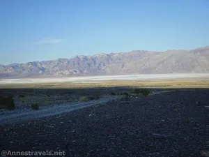
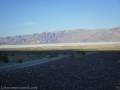
0.0 Shorty’s Well on left (east)/Hanaupah Canyon Road on right (west) Junction on the West Side Road (-241ft.). Shortys Well is to the east and Hanaupah Canyon is to the west. Turn west up the Hanaupah Canyon Road. The road is rough and rocky but passable by high clearance 2WD vehicles for the first five miles to the top of the alluvial fan. Be sure to look back down on Badwater Flats and the Black Mountains. (36.225719°, -116.881447°)
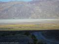
4.8 Enter wash (1,675ft.). 4×4 is required beyond this point. Continue to follow the road upcanyon. The canyon tends to be wide and brushy. Some of the road is in good repair; other parts are rocky and require the driver to slow down. (36.210760°, -116.960634°)
8.2 End of Hanaupah Canyon Road (3,212ft.). Exactly where the road ends is approximate; obey the signs. (approx. 36.188558°, -117.005375°)
History & More
Telescope Peak – the highest point in Death Valley National Park – looms above Hanaupah Canyon. It’s nearly 8,000ft. in vertical elevation change between the end of the road to the top of the peak.
I have not be able to track down how the canyon was named; however, Alexander Zachariah “Shorty” Borden prospected for gold and mined silver in the canyon in the late 1800s. While he never struck it rich, he did walk for miles over the entire area, discovering other interesting riches including his well along what is now the West Side Road.
“Shorty” Borden decided to make his fortune by creating a camp in Hanaupah Canyon. Shortly before he opened it to visitors, an enormous flash flood washed the entire camp down onto Badwater Salt Flats. Shorty heard it coming and barely made it to safety on higher ground. Without supplies, he knew he would have to hike to civilization, so he set off at dusk (by this time, he knew quite a bit about the desert, including that you don’t want to hike in the summer heat) – only to find the mouth and alluvial fan of the canyon blocked with mud and debris. It took him most of the night just to wade through the mess. A man named Monroe Wagnon took some trash out to his incinerator in Furnace Creek the next day and spotted Shorty wandering out in the desert – dehydrated and delirious with heat exhaustion. Monroe nursed him back to health, then rescued Shorty again a few days later when the latter tried to hike up to a friend’s cabin/claim in the Panamint Mountains. Shorty took his time recovering after that and lived for many more years, finally dying peacefully at a rest home in San Bernardino.
Download Route Map
Driving Directions
The Hanaupah Canyon Road is located directly across the West Side Road from the short road to Shorty’s Well, 10.7 miles south of the northern terminus of the West Side Road and 25.2 miles north of the southern terminus of the West Side Road.
Camping in a canyon is discouraged due to the danger of flash floods.
Remember, it may be easier to climb up dryfalls than down them (or vice versa). Be sure you can climb in the other direction before climbing up or down a dryfall.
Camping is not allowed within one mile of a paved road, developed area, or dirt road that is closed to camping.
Camping is not permitted within 100 feet of a flowing stream, spring, or other natural body of open water.
No camping is permitted on the floor of Death Valley, within one mile of Darwin Falls and Greenwater Canyon, on the active/shifting sand dunes, and certain other canyons and backcountry areas.
Camping is also prohibited within one mile of the Ubehebe Lead Mine, Leadfield Mines, Keane Wonder Mill, and Skidoo Mill.
Camping is limited to 30 days per calendar year within the park.
Fires are permitted in NPS-provided fire grates or grills ONLY.
Leave No Trace Principles are enforced
Drones and model aircrafts are prohibited
Camping is permitted only in designated sites or in areas open to dispersed backcountry camping
All park rules and regulations
12 Month Pass: $55/Death Valley Annual Pass (valid at Death Valley National Park). $80/America the Beautiful Annual Pass (valid at all national park and federal fee areas). $20/Annual Senior Pass (62 years or older US citizens; valid at all national park and federal fee areas). Free/4th Grade Pass (Valid Sept. 1-August 31 of the child’s 4th Grade school year). Free/Military Pass (valid for all active military personel and their dependents with a CAC Card or DD Form 1173).
Lifetime Pass: $80/Lifetime Senior Pass (62 years or older US citizens; valid at all national park and federal fee areas). Free/Access Pass (available to all US citizens with perminent disabilities). Free/Access for Veterans and Gold Star Families Pass (valid for all military and veterans with a CAC card, Veteran HJealth Identification Card, Veteran ID Card, or veteran’s designation on state-issued drivers license or identification card.)