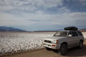
Dirt Road: West Side Road – Death Valley National Park


High clearance-required dirt/gravel road that travels along the west side of Badwater Flats and gives access to 4×4 roads up desert canyons, historic sites, beautiful views, and more.
| Total Distance: 35.9 miles point-to-point | Elevation Gain: 751ft. gain, 736ft. loss N to S |
| Road Difficulty: 1.5 (high clearance required) | Bicycle Difficulty: More Difficult |
| View Rating: 4.0 out of 5.0 stars | Author’s Rating: 3.0 out of 5.0 stars |
| Visitor Rating: (Click to rate) [Total: 0 Average: 0] | Visitor Difficulty Rating: (Click to rate) [Total: 0 Average: 0] |
| Pets: Leashed | Horses: Yes (on road) |
| Best Seasons: October-May | Special Permits: None |
| Water Availability: None | Overnight Options: None unless you turn up one of the roads into the mountains |
| Amenities: None | Crowd Factor: Solitude to Moderate |
| Uses: | Road surface: |
| Features: | Hazards: |
Mile-by-Mile: West Side Road
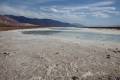
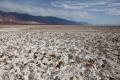
0.0 West Side Road/Badwater Road Junction (north end) (-67ft.). Drive southwest. The road crosses salt flats (impassible when wet) before becoming rougher on the gravel at the base of the mountains. Road conditions are dependent on how recently the road has been graded by the National Park Service. In dry, well-graded conditions, low clearance can likely make it to the first pullout or even to the gravel on the other side of the salt flats. (36.365833°, -116.844937°)
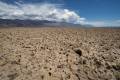
1.8 Pullout #1 (-274ft.). A small pullout allows access to nearby mud formations and salt flats. Three more pullouts are located at approximately mile 2.3, 2.8, and 3.25. After the fourth pullout, the road changes character and begins to travel south through land at the base of the washes that carry rocks and gravel out of the mountains. Because of this, the road becomes rougher, especially after summer monsoon rains cause flash floods across the road. (36.3450380°, -116.8637215°)
5.3 Trail Canyon Road Junction on right (west) (-256ft.). Continue straight (left) on the West Side Road. (36.303036°, -116.890578°)
9.5 Tule Spring Road Junction on left (east) (-246ft.). Continue straight (right) on the West Side Road. (36.242670°, -116.884728°)
10.7 Shortys Well on left (east)/Hanaupah Canyon Road on right (west) Junction (-241ft.). Shortys Well is to the east and Hanaupah Canyon is to the west. Continue straight on the West Side Road. (36.225719°, -116.881447°)
12.2 Dayton Harris Monument on left (east) (-256ft.). Jim Dayton and Shorty Harris are buried here – possibly buried deeper than anyone else in America. (36.207309°, -116.870803°)
12.7 Eagle Borax Works Spur Road on left (east) (-251ft.). Continue straight (right) down the West Side Road. (36.200255°, -116.870558°)
15.9 Bennett-Arcan Long Camp monument on left (east) (-253ft.). Near this monument, a group of miners became stranded while scouting out a shortcut to the California gold fields. After more than a month, two members of the party journeyed to Rancho San Francisquito near Newhall to get supplies and water. They returned safely and led the party back to the ranch. (36.163388°, -116.863393°)
20.7 Johnson Canyon Road Junction on right (west) (-250ft.). Continue straight (left) on the West Side Road. (36.098192°, -116.845458°)
25.5 Galena Canyon Road on right (west) (-246ft.). Continue straight (left) on the West Side Road. (36.031885°, -116.831105°)
25.7 Queen of Sheba Mine Road on right (west) (-243ft.). Continue straight (left) on the West Side Road. (36.030091°, -116.829482°)
25.75 Water Tanks on left (east) (-243ft.). Once used for the 20 Mule Team, these metal tanks held water piped down from the mountains. Today, some call the tanks “the most interesting part of the West Side Road.” (36.029915°, -116.829139°)
32.9 Warm Spring Canyon Road on right (west) (-219ft.). Continue straight (left) on the West Side Road. (35.954105°, -116.746626°)
35.9 West Side Road South End at Badwater Road (-46ft.). Turn left to return to Badwater Basin and Furnace Creek; turning right will take you to the Jubilee Pass Road. (35.937710°, -116.704620°)
History & More
The West Side Road was used to access the various canyons on the east side of the Panamint Mountains, most of which contained some form of mining operations. Up into the 1970s, some of these mines were still open for extracting ore.
The 20 Mule Team sometimes used the West Side Road, although mostly the teams stopped by the water tanks to replenish their water reserves. Any water was valuable in this arid land, and the next water stop was likely the Saratoga Springs in the far south of Death Valley.
The Dayton-Harris Monument marks the graves of two early prospectors (who, very possibly, are buried deeper than anyone else in North America – after all, the ground level is lower than almost anywhere else in North America!)
The West Side Road is a favorite for wildflower hunters in the early spring (February-March).
Download Route Map
Driving Directions
Northern terminus: 5.9 miles south of Badwater Junction on the Badwater Road, or 10.6 miles north of the Badwater Basin Parking Area via the Badwater Road.
Southern Terminus: 41.9 miles south of Badwater Junction on the Badwater Road, or 3.7 miles north of the Harry Wade Road/Jubilee Pass Road/Badwater Road Junction.
It is extremely dangerous to enter a mine due to unstable shafts, gasses, and more. Do not enter mines, even if they are apparently open!
Walking on, climbing, entering, ascending, descending, or traversing any mine, structure, feature, or ruin is prohibited.
Toxic chemicals or ore may be present around mine sites. Enter at your own risk.
Possessing, destroying, injuring, defacing, removing, digging, or disturbing any mine, structure, feature, or ruin is also prohibited.
Always be wary of flash floods in a canyon.
Camping in a canyon is discouraged due to the danger of flash floods.
Remember, it may be easier to climb up dryfalls than down them (or vice versa). Be sure you can climb in the other direction before climbing up or down a dryfall.
Camping is not allowed within one mile of a paved road, developed area, or dirt road that is closed to camping.
Camping is not permitted within 100 feet of a flowing stream, spring, or other natural body of open water.
No camping is permitted on the floor of Death Valley, within one mile of Darwin Falls and Greenwater Canyon, on the active/shifting sand dunes, and certain other canyons and backcountry areas.
Camping is also prohibited within one mile of the Ubehebe Lead Mine, Leadfield Mines, Keane Wonder Mill, and Skidoo Mill.
Camping is limited to 30 days per calendar year within the park.
Fires are permitted in NPS-provided fire grates or grills ONLY.
Leave No Trace Principles are enforced
Drones and model aircrafts are prohibited
Camping is permitted only in designated sites or in areas open to dispersed backcountry camping
All park rules and regulations
12 Month Pass: $55/Death Valley Annual Pass (valid at Death Valley National Park). $80/America the Beautiful Annual Pass (valid at all national park and federal fee areas). $20/Annual Senior Pass (62 years or older US citizens; valid at all national park and federal fee areas). Free/4th Grade Pass (Valid Sept. 1-August 31 of the child’s 4th Grade school year). Free/Military Pass (valid for all active military personel and their dependents with a CAC Card or DD Form 1173).
Lifetime Pass: $80/Lifetime Senior Pass (62 years or older US citizens; valid at all national park and federal fee areas). Free/Access Pass (available to all US citizens with perminent disabilities). Free/Access for Veterans and Gold Star Families Pass (valid for all military and veterans with a CAC card, Veteran HJealth Identification Card, Veteran ID Card, or veteran’s designation on state-issued drivers license or identification card.)