Corridor Canyon – Death Valley National Park


Hike down a canyon with fossils, narrows, and slippery dryfalls to a very straight, sheer-faced canyon deep in the Last Chance Range.
| Total Distance: 7.8 miles out & back with spur | Elevation Gain: 1,980ft. (3,860ft. to 2,880ft.) |
| Difficulty: Strenuous | 5-10 Mile Difficulty: Very Strenuous |
| View Rating: 3.0 out of 5.0 stars | Author’s Rating: 4.0 out of 5.0 stars |
| Visitor Rating: (Click to rate) [Total: 0 Average: 0] | Visitor Difficulty Rating: (Click to rate) [Total: 0 Average: 0] |
| Pets: No | Horses: Yes |
| Best Seasons: November-April | Special Permits: None |
| Water Availability: None | Overnight Options: Dispersed camping is permitted at least a mile from the Racetrack Road (aka not at the trailhead) |
| Trailhead Amenities: None | Crowd Factor: Solitude |
| Trailhead Access: 1.9 or 2.0 | |
| Uses: | Trail Surface: |
| Features: | Hazards: |
Mile-by-Mile: Corridor Canyon
0.0 Ubehebe Lead Mine Parking Area (3,861ft.). You’ll be walking downcanyon for the entire outbound hike. Walk down the canyon (west) past the old mining area with quite a bit of historical remains. Walk around at your own risk and try not to disturb/breathe the dust any more than necessary. Old mine shafts pierce the area, along with many old mine implements/buildings and an old tramway. Before the first bend in the canyon, the route enters the Death Valley Wilderness Area. The canyon in this first area is pretty but not terribly narrow. Also, keep your eyes open for fossils in the rocks, especially in and below the first narrows. (36.749246°, -117.585270°)
0.4 First major side-wash on right (east) (3,742ft.). Take note of this junction to make sure you remember which route to take on your way back. Continue left downcanyon. (36.7525380°, -117.5879540°)
0.9 First Major Side-wash on right (north) (3,622ft.). Look back at this junction to make sure you remember to take the correct wash (the southerly one) on the way back. (36.753389°, -117.592630°)
1.5 Enter First Narrows (3,449ft.). Enjoy the narrow canyon; near the end, rock art can be found on the righthand (northern) wall. (36.755156°, -117.600835°)
1.6 End of First Narrows; enter wide wash (3,391ft.). Look back at this junction to make sure you remember to take the correct (much smaller!) wash on your return – this is possibly the most confusing junction for your trek back. Turn left to walk down the wide wash. There are many fossils in this area, so keep your eyes open. A few small dryfalls pose fun slides/minor obstacles. Enjoy a short (both in length and height) slot section about mile 2.3 – a fun variation on the theme of slot canyons. Continuing downcanyon, the walls tower over the wash as it becomes narrower. (36.754687°, -117.602334°)
2.8 Enter Third Narrows (3,077ft.). This is the most impressive and most extensive of the narrows in Corridor Canyon. About halfway down, you’ll come to a rather sketchy-looking dryfall. It appears to be very slippery and about 12ft. high. It can be descended (and re-ascended) with some careful climbing, but a rope is helpful, especially for shorter hikers (yes, I am one, and yes, I was thankful for my 6ft. companion’s hand to give me a pull back up!). The canyon below the sketchy dryfall is very pretty, with patterns in the rocks and another dryfall or two (much easier than the sketchy one, thankfully!) (36.749418°, -117.614989°)
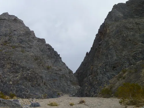
3.0 Enter The Corridor (3,064ft). The “Corridor” is an almost mile-long canyon straight north-south through the mountains. This is one of the easier junctions to find on the way back up, but you’ll still want to memorize the junction – a break in an almost straight, unbroken cliff wall. To see the entire Corridor, turn right to go upstream. (36.748758°, -117.616916°)
3.3 Dryfall (3,093ft.). This is the head of the Corridor, though it may be possible to explore further upstream by climbing up the rockfall/dryfall on its left side. Retrace your steps back down to the slot entrance and then continue downstream. The Corridor is not very narrow, but it’s fascinating in terms of the almost sheer walls on either side and how straight it cuts through the Last Chance Range. (36.752730°, -117.618148°)
4.2 End of the Corridor (2,890ft.). The canyon doubles back on itself at this point. While most people opt to turn around here, there’s no reason you can’t continue to explore downstream if you want to – at least to the next dryfall! (36.739708°, -117.615712°)
History & More
Corridor Canyon is named for the nearly mile-long, almost completely straight “corridor” through the hills. While it’s not especially narrow, there are some cool slots to explore en route to Corridor Canyon as well as a pretty canyon experience along most of its route.
There are several slick dryfalls along the route, but most are short enough that they don’t pose much in the way of challenge. The 12ft. dryfall is the one real obstacle. If you’re not comfortable with it, the hike is still worth the effort to see the narrows. Some hikers like to bring along a rope to help each other down (and up!) the dryfall.
I climbed the dryfall at the head of Corridor Canyon far enough to find a flat area that would be a pond in wet weather.
Corridor Canyon eventually empties out into Saline Valley (about 3 miles below the turnaround point in this guide). I had never heard of anyone doing a shuttle trip between the Ubehebe Lead Mine and the Saline Valley Road, but I managed to navigate the dryfalls – and did it, though it was a very, very long and strenuous day!
Download Trail Map
Coming soon!
Driving Directions
Take the Racetrack Road from the Ubehebe Crater Road 21.7 miles from the crater. Turn right onto the unmarked dirt road heading west – otherwise known as the Ubehebe Lead Mine Road. Drive 0.75 miles to the end of the road and park near the ruins.
Camping in a canyon is discouraged due to the danger of flash floods.
Remember, it may be easier to climb up dryfalls than down them (or vice versa). Be sure you can climb in the other direction before climbing up or down a dryfall.
Camping is not allowed within one mile of a paved road, developed area, or dirt road that is closed to camping.
Camping is not permitted within 100 feet of a flowing stream, spring, or other natural body of open water.
No camping is permitted on the floor of Death Valley, within one mile of Darwin Falls and Greenwater Canyon, on the active/shifting sand dunes, and certain other canyons and backcountry areas.
Camping is also prohibited within one mile of the Ubehebe Lead Mine, Leadfield Mines, Keane Wonder Mill, and Skidoo Mill.
Camping is limited to 30 days per calendar year within the park.
Fires are permitted in NPS-provided fire grates or grills ONLY.
Leave No Trace Principles are enforced
Drones and model aircrafts are prohibited
Camping is permitted only in designated sites or in areas open to dispersed backcountry camping
All park rules and regulations
12 Month Pass: $55/Death Valley Annual Pass (valid at Death Valley National Park). $80/America the Beautiful Annual Pass (valid at all national park and federal fee areas). $20/Annual Senior Pass (62 years or older US citizens; valid at all national park and federal fee areas). Free/4th Grade Pass (Valid Sept. 1-August 31 of the child’s 4th Grade school year). Free/Military Pass (valid for all active military personel and their dependents with a CAC Card or DD Form 1173).
Lifetime Pass: $80/Lifetime Senior Pass (62 years or older US citizens; valid at all national park and federal fee areas). Free/Access Pass (available to all US citizens with perminent disabilities). Free/Access for Veterans and Gold Star Families Pass (valid for all military and veterans with a CAC card, Veteran HJealth Identification Card, Veteran ID Card, or veteran’s designation on state-issued drivers license or identification card.)