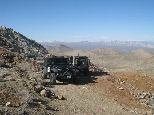
Chloride Cliffs Road – Death Valley National Park


Photo credit The Greater Southwestern Exploration Company, CC BY 2.0. View at https://flic.kr/p/2oTTGBQ
Dirt road from US-95 to the Chloride City Road.
| Total Distance: 11.5 miles point-to-point | Elevation Gain: 1,554ft. up, 119ft. down (2,913ft. to 4,405ft.) |
| Road Difficulty: 2.0 | Bicycle Difficulty: More Difficult |
| View Rating: 3.0 out of 5.0 stars | Rating: 1.0 out of 5.0 stars |
| Visitor Rating: (Click to rate) [Total: 0 Average: 0] | Visitor Difficulty Rating: (Click to rate) [Total: 0 Average: 0] |
| Pets: Leashed | Horses: Yes |
| Best Seasons: October-May | Special Permits: None |
| Water Availability: None | Overnight Options: Dispersed camping permitted after entering Death Valley National Park |
| Amenities: None | Crowd Factor: Solitude to Moderate |
| Uses: | Road surface: |
| Features: | Hazards: |
Mile-by-Mile: Chloride Cliffs Road
0.0 Beginning of Chloride Cliffs Road on US-95 (2,936ft.). Drive southwest on the Chloride Cliffs Road. (36.812225°, -116.729473°)
1.2 Road junction (2,929ft.). Continue straight; turning would take you to a tank and radio tower. (36.802969°, -116.747535°)
1.6 Road Y (2,923ft.). Veer right to travel west. The road is generally sandy and easy to drive. (36.800920, -116.752940)
2.6 Road junction (2,923ft.). Continue straight (southwest). (36.791862°, -116.768108°)
7.4 Road enters from right (north) (3,476ft.). Continue straight (southwest). (36.746931°, -116.831540°)
8.8 California/Nevada State Border; Enter Death Valley National Park (3,809ft.). Continue southwest. (36.731650°, -116.847331°)
11.5 Chloride City Road (4,371ft.). The very rough road to the left leads up to Chloride City and the Chloride Cliffs. The rough road to the right leads down to the Daylight Pass Road. (36.717606°, -116.885267°)
History & More
The Chloride Cliffs Road was likely created during one of the phases of development around the mines in the Chloride Cliffs District. Today it’s one way to have a slightly easier access to the Chloride City Road (though you’ll still need 4×4, especially once you turn onto the road to Chloride City).
The border of Death Valley National Park follows the Nevada/California border at this point. So as soon as you enter California, you’re also entering the park. Note that the entrance fee is required to enter the park even if there is no fee station on the Chloride Cliffs Road.
Download Trail Map
Coming soon!
Driving Directions
Take US-95 south from Beatty, Nevada. The unmarked dirt road will cross the highway after 7.2 miles. Turn right (west).
Or from the south, take US-95 north from Amargosa Valley, Nevada (the point where NV-373 meets US-95). Drive 22.2 miles to where an unmarked dirt road crosses the highway; turn left (west).
Camping is not permitted within 100 feet of a flowing stream, spring, or other natural body of open water.
No camping is permitted on the floor of Death Valley, within one mile of Darwin Falls and Greenwater Canyon, on the active/shifting sand dunes, and certain other canyons and backcountry areas.
Camping is also prohibited within one mile of the Ubehebe Lead Mine, Leadfield Mines, Keane Wonder Mill, and Skidoo Mill.
Camping is limited to 30 days per calendar year within the park.
Fires are permitted in NPS-provided fire grates or grills ONLY.
Leave No Trace Principles are enforced
Drones and model aircrafts are prohibited
Camping is permitted only in designated sites or in areas open to dispersed backcountry camping
All park rules and regulations
12 Month Pass: $55/Death Valley Annual Pass (valid at Death Valley National Park). $80/America the Beautiful Annual Pass (valid at all national park and federal fee areas). $20/Annual Senior Pass (62 years or older US citizens; valid at all national park and federal fee areas). Free/4th Grade Pass (Valid Sept. 1-August 31 of the child’s 4th Grade school year). Free/Military Pass (valid for all active military personel and their dependents with a CAC Card or DD Form 1173).
Lifetime Pass: $80/Lifetime Senior Pass (62 years or older US citizens; valid at all national park and federal fee areas). Free/Access Pass (available to all US citizens with perminent disabilities). Free/Access for Veterans and Gold Star Families Pass (valid for all military and veterans with a CAC card, Veteran HJealth Identification Card, Veteran ID Card, or veteran’s designation on state-issued drivers license or identification card.)
1 thought on “Chloride Cliffs Road – Death Valley National Park”