Desolation Canyon South Fork – Death Valley National Park


A short hike up a trailless desert canyon between badland hills that beings at the same parking area as the main fork of Desolation Canyon.
| Total Distance: 1.9 miles out & back | Elevation Gain: 597ft. (-73ft. to 295ft.) |
| Difficulty: Easy | 0-5 Mile Difficulty: Moderate |
| View Rating: 2.0 out of 5.0 stars | Author’s Rating: 1.0 out of 5.0 stars |
| Visitor Rating: (Click to rate) [Total: 0 Average: 0] | Visitor Difficulty Rating: (Click to rate) [Total: 0 Average: 0] |
| Pets: No | Horses: No |
| Best Seasons: November-April | Special Permits: None |
| Water Availability: None | Overnight Options: None |
| Trailhead Amenities: None | Crowd Factor: Solitude |
| Trailhead Access: 1.1 | |
| Uses: | Trail Surface: |
| Features: | Hazards: |
Mile-by-Mile: Desolation Canyon South Fork Route
0.0 Desolation South Canyon (-73ft.). Take the lesser-used old road that heads almost due south from the parking area into a wash. Turn left (south/east) when you eventually drop into the wash. (36.395512°, -116.838714°)
0.25 Drop into wash (16ft.). Turn left up the wash (you don’t have to drop into the wash here, specifically; it’s just near where I dropped into the wash). The tread is a little firmer underfoot as the wash heads southeast into the hills. (36.3918060°, -116.8376030°)
0.5 Wash split (89ft.). The wash splits in two at this point. The main canyon turns left, so that’s the way I’ll tell you to go first, even though there are some fun (if rugged) things to the right, too. The main wash continues upward between yellow hills. The canyon narrows and becomes more rugged, though in general, the scrambling is nothing more than a mild Class 3. (36.389784°, -116.835501°)
0.6 Dryfall. (226ft.). A dryfall blocks upward progress. I explored a few of the small side canyons on my way back downcanyon (not included in the mileage, though a few pictures are from up where I could see into the side fork). (36.3887223°, -116.8330919°)
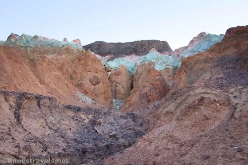
0.8 Return to wash split (89ft.). This is where you turned left up the main canyon earlier. Now, turn left (it would have been right as you came up the canyon) up the narrower canyon. The tread is rocky but no more than a Class 2 scramble. The canyon walls close in around the wash. Keep your eyes open for colorful rocks both below your feet and high on the cliffs above your head. Stay in the main wash as it passes several potentially interesting side canyons. I turned around at the ends of various colorful side canyons, including 36.3886920°, -116.8329970°, 36.3877160°, -116.8338420°, and 36.3871960°, -116.8344170°. While this fork of the canyon is much more rugged to explore, it also has much more colorful walls, hills, and rocks than the yellow main canyon. When you’re finished exploring, retrace your steps down to the parking area. (36.389784°, -116.835501°)
1.9 Return to parking area (-73ft.). (36.395512°, -116.838714°)
History & More
Many of the yellow-tinted rocks in Death Valley have a high concentration of Limonite, a type of iron ore. The badlands around the South Fork of Desolation Canyon are yellow. If you go over the ridge to look down into Artist Pallette, you can see other colors – the purple and red/orange rocks have hematite in them, and green or blue rock is comprised of chlorite or nontronite.
A road once traveled partway up the canyon. However, I was unable to find evidence of it except on old maps.
Download Trail Map
Driving Directions
From Furnace Creek, take CA-190 East for 1.3 miles. Turn right on the Badwater Road. After 3.7 miles, turn left on the gravel road (it may or may not be signed for Desolation Canyon). The trailhead is up the gravel road 0.5 miles from the paved road. The parking area is large enough to accommodate small RVs.
From Death Valley Junction, take CA-190 West 28.9 miles to the Badwater Road. Turn left, following the sign for Badwater. After 3.7 miles, turn left on the gravel road (it may or may not be signed for Desolation Canyon). The trailhead is up the gravel road 0.5 miles from the paved road. The parking area is large enough to accommodate small RVs.
From the south, drive north on the Badwater Road. The right turn onto the gravel road to the parking area is 1.1 miles north of the exit to Artist’s Drive (4.9 miles north of the entrance to Artist’s Drive).
Remember, it may be easier to climb up dryfalls than down them (or vice versa). Be sure you can climb in the other direction before climbing up or down a dryfall.
Leave No Trace Principles are enforced
Drones and model aircrafts are prohibited
Camping is permitted only in designated sites or in areas open to dispersed backcountry camping
All park rules and regulations
12 Month Pass: $55/Death Valley Annual Pass (valid at Death Valley National Park). $80/America the Beautiful Annual Pass (valid at all national park and federal fee areas). $20/Annual Senior Pass (62 years or older US citizens; valid at all national park and federal fee areas). Free/4th Grade Pass (Valid Sept. 1-August 31 of the child’s 4th Grade school year). Free/Military Pass (valid for all active military personel and their dependents with a CAC Card or DD Form 1173).
Lifetime Pass: $80/Lifetime Senior Pass (62 years or older US citizens; valid at all national park and federal fee areas). Free/Access Pass (available to all US citizens with perminent disabilities). Free/Access for Veterans and Gold Star Families Pass (valid for all military and veterans with a CAC card, Veteran HJealth Identification Card, Veteran ID Card, or veteran’s designation on state-issued drivers license or identification card.)
1 thought on “Desolation Canyon South Fork – Death Valley National Park”