Historic Stovepipe Well Road – Death Valley National Park


Visit an old watering hole that was critical to both the indigenous population and miners and explorers who came to Death Valley.
| Total Distance: 0.75 miles point to point (dead end) + 0.1 miles out & back on foot | Elevation Gain: 18ft. up, 137ft. down (70ft. to -58ft.) |
| Road Difficulty: 1.2 | Bicycle Difficulty: Easy |
| View Rating: 3.0 out of 5.0 stars | Author’s Rating: 2.0 out of 5.0 stars |
| Visitor Rating: (Click to rate) [Total: 0 Average: 0] | Visitor Difficulty Rating: (Click to rate) [Total: 0 Average: 0] |
| Pets: Leashed | Horses: No |
| Best Seasons: October-May | Special Permits: None |
| Water Availability: None | Overnight Options: None |
| Amenities: None | Crowd Factor: Solitude |
| Uses: | Road surface: |
| Features: | Hazards: |
Mile-by-Mile: Historic Stovepipe Well Road
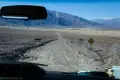
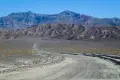
0.0 Road to the Historic Stovepipe Well Junction on Scotty’s Castle Road (70ft.). Turn southwest down the gravel road. (36.668894°, -117.073931°)
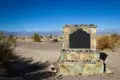
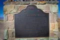
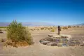
0.75 Parking area (-49ft.). A plaque nearby describes the history of Stovepipe Well. Continue on foot north and west to the historic well. (36.658963°, -117.079331°)
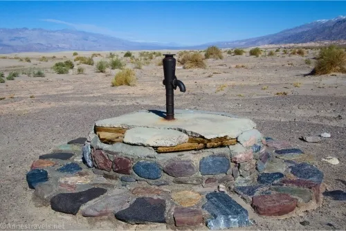
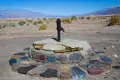
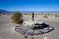
0.8 Historic Stovepipe Well (-48ft.). Enjoy the views to the Mesquite Sand Dunes and nearby mountains. You can explore the sand beyond the well if desired, though it’s a bit of a walk to get to the sand dunes themselves. (36.659022°, -117.079664°)
History & More
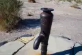
The Stovepipe Well was at the junction of two ancient trails through Death Valley. The Cross-Valley Road in the time of the mining booms also passed by the well. Shifting sands often obscured the location of the well, so an enterprising traveler marked it with an old stovepipe, giving the well its name. Today, although marked by a pump, the water at Stovepipe Wells is not potable.
Stovepipe Well was the only waterhole on the Cross-Valley Road between Rhyolite and Skidoo.
Visitors have noted that the historic sign marking the well states that this is State Registered Landmark No. 726. However, books and websites record it as California Historic Landmark 826 – according to official sources, Landmark 726 is the Sebastian Store in San Luis Obispo County.
At one time, an old road traveled south from the well to CA-190. It has been closed by the National Park Service, though it is still visible on satellite imagery and some older topo maps.
Download Trail Map
Coming soon!
Driving Directions
Drive north from CA-190 on the Scotty’s Castle Road. The Historic Stovepipe Well Road is on the left (west) after 3.0 miles. The road is also 11.9 miles south of the Titus Canyon Road.
Leave No Trace Principles are enforced
Drones and model aircrafts are prohibited
Camping is permitted only in designated sites or in areas open to dispersed backcountry camping
Click here for all park rules and regulations
12 Month Pass: $55/Death Valley Annual Pass (valid at Death Valley National Park). $80/America the Beautiful Annual Pass (valid at all national park and federal fee areas). $20/Annual Senior Pass (62 years or older US citizens; valid at all national park and federal fee areas). Free/4th Grade Pass (Valid Sept. 1-August 31 of the child’s 4th Grade school year). Free/Military Pass (valid for all active military personel and their dependents with a CAC Card or DD Form 1173).
Lifetime Pass: $80/Lifetime Senior Pass (62 years or older US citizens; valid at all national park and federal fee areas). Free/Access Pass (available to all US citizens with perminent disabilities). Free/Access for Veterans and Gold Star Families Pass (valid for all military and veterans with a CAC card, Veteran HJealth Identification Card, Veteran ID Card, or veteran’s designation on state-issued drivers license or identification card.)
1 thought on “Historic Stovepipe Well Road – Death Valley National Park”