Titus Canyon Road – Death Valley National Park


Follow a gravel road to views, an old mining community, petroglyphs, and a slot canyon.
| Total Distance: 26.3 miles point to point (one-way road) | Elevation Gain: 3,060ft. up, 6,302ft. down (5,261ft. to 175ft.) |
| Road Difficulty: 1.5 | Bicycle Difficulty: More Difficult |
| View Rating: 5.0 out of 5.0 stars | Author’s Rating: 3.0 out of 5.0 stars |
| Visitor Rating: (Click to rate) [Total: 0 Average: 0] | Visitor Difficulty Rating: (Click to rate) [Total: 0 Average: 0] |
| Pets: Leashed | Horses: Yes |
| Best Seasons: October-May | Special Permits: None |
| Water Availability: None | Overnight Options: None |
| Amenities: Primitive restroom at the Fall Canyon Trailhead | Crowd Factor: Moderate |
| Uses: | Road surface: |
| Features: | Hazards: |
Mile-by-Mile: Titus Canyon Road
0.0 Titus Canyon Road on the Daylight Pass Road (3,416ft.). The road is signed for Titus Canyon. Titus Canyon Road is a favorite for jeepers and motorcyclists, though it can usually be driven by most 2WD, high clearance vehicles. Traffic is one-way driving from north (here) to the mouth of Titus Canyon; from the mouth to the south end of the road (at Scotty’s Castle Road) is two-way traffic. Take the reasonable (if with washboard) gravel road west across the desert. (36.859137°, -116.845884°)
1.8 Enter Death Valley National Park (3,609ft.). A few ruins are nearby. (approx. 36.745206°, -116.902177°).
6.0 Enter the Grapevine Mountains (4,243ft.). The road turns south here, deep into the Grapevine Mountains via an unnamed canyon. (36.846995°, -116.954795°)
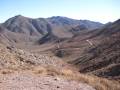
9.4 Pulloff on right (5,110ft.). Views from here reach west down toward Titanothere Canyon and beyond to nearby peaks. Continue down into the canyon. (36.826699°, -117.000611°)
9.9 Cross Wash (4,995ft.). This is the first trailhead for Titanothere Canyon. A fossil of a Titanothere (also known as a brontotheres, a dinosaur similar to a rhinoceros) was found in the canyon in 1933. Continue on the road. After a second wash, the road begins to ascend to Red Pass. (36.828949°, -117.008037°)
11.0 Titanothere Canyon (4,664ft.). This is the second (and probably more official) trailhead for Titanothere Canyon. Continue on the road, which is rougher than before but should still be passable, especially with high clearance. (36.827257°, -117.022345°)
12.2 Red Pass (5,261ft.). Enjoy views of the nearby colorful mountains. The road after this tends to be rougher than on the other side of the pass and is the reason high clearance is recommended for this road. (36.828758°, -117.032467°)
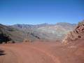
14.4 Pulloff on left (4,315ft.). Some prospects and slag piles are nearby. Continue on the main road as it winds down into a sidecanyon off of Titus Canyon. (36.839447°, -117.049123°)
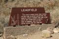
15.3 Leadfield (4,015ft.). A parking area is on the right with a pulloff on the left. The old mining town is a worthy stop if you have time. Continue down the main road. (36.848341°, -117.059273°)
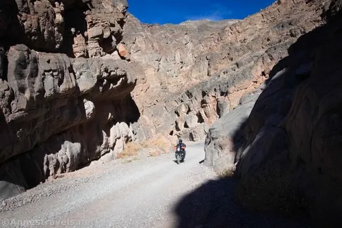
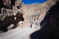
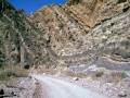
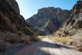
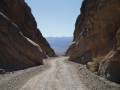
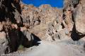
16.0 Enter Titus Canyon (3,742ft.). This is where the real excitement begins. The canyon walls rise high above the road. Keep your eyes open for bighorn sheep, hanging gardens, and massive cliffs. (36.853169°, -117.066764°)
17.9 Petroglyph Rock (3,083ft.). Petroglyphs on a boulder have been badly vandalized, but you can still see the shapes. (36.841196°, -117.090654°)
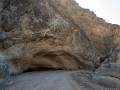
17.95 Klare Spring (3,076ft.). This is an excellent place to view wildlife, especially bighorn sheep. After the spring, the canyon is fairly wide, with good views of the layers in the nearby mountains and cliffs. About mile 19.3, the road climbs up onto the left (south) bench beside the wash. Right after this, the road enters the Lower Narrows of Titus Canyon; however, the narrowest section does not begin until mile 22. As the canyon narrows to less than 20 feet in width, the road leaves the wash on a descent that is often quite rough – you may wish to explore this on foot before driving it. As you drive downcanyon, be wary of hikers hiking up into the narrows. (36.840990°, -117.090998°)
23.7 Exit Titus Canyon (930ft.). This is the parking area for Fall Canyon and hikers walking up Titus Canyon. From this point on, the road has two-way traffic as it descends the alluvial fan. (36.822044°, -117.173873°)
26.3 Scotty’s Castle Road (175ft.). Turn right to continue up toward the Ubehbe Crater and Scotty’s Castle, or turn left to return to the Daylight Pass Road and the main part of Death Valley. (36.787706°, -117.191546°)
History & More
The Titus Canyon Road may be impassable or require 4×4 when wet. The NPS closes the road after storms, as the roadbed can become washed out.
In 1933, a dinosaur fossil was found in Titanothere Canyon. The dinosaur was a Titanothere (also known as a Brontotheres), thus the canyon’s name. A Titanothere is similar to a rhinoceros.
Leadfield was a short-lived boom town mining – what else? – lead. However, the deposits were not large (it’s said that the boom was manufactured to draw in investors, even though the miners knew there wasn’t much to extract from the mountains.) The town was abandoned after less than a year.
The Timbisha American Indians carved petroglyphs into the rocks near Klare Spring. These prehistoric carvings depict desert animals, geometric designs, and more.
Titus Canyon is one of the best places in Death Valley to spot desert bighorn sheep. However, the sheep are masters of disguise – almost invisible when standing still. Watch for movements of white (the sheep’s rump) and drive slowly.
Titus Canyon was named for Morris Titus. In 1906, Morris and several other prospectors left Rhyolite to seek their fortunes in the Grapevine Mountains. While camped in Titus Canyon, water supplies ran low. Morris left for help and more supplies, but his fate is unknown. What we do know is that he did not return to the camp or to Rhyolite.
Be wary of hikers in the Titus Canyon Narrows. Many people begin at the Fall Canyon Trailhead and hike up the narrows instead of driving the entire road.
In the early days of the Bullfrog Gold Boom, prospectors discovered lead and copper near where the town of Leadfield would be built. Despite the high value of the ore, transportation was too expensive to be profitable. In the mid-1920s, the Western Lead Mine Company and Charles C. Julian once again took up mining in the area. Advertisements to attract investors showed steamboats on the Amargosa River headed for Leadville, despite the fact that the river flows some 20 miles away from the town when it isn’t dry – which is much of the year. C.C. Julian constructed the Titus Canyon Road to give access to his mine, brought in investors, and built several buildings. The town opened a post office in July of 1926, about the time the population reached 300, but it closed within six months as lead deposits ran out, Mr. Julian declared bankruptcy, another investor escaped to Singapore, and the boom town declined.
Many people visit Rhyolite before starting down the Titus Canyon Road since the two aren’t too far apart and Rhyolite is quite a distance from anything else in Death Valley.
Download Trail Map
Coming soon!
Driving Directions
Take the Daylight Pass Road (NV-374) to the sign for Titus Canyon Road. The turnoff is 7.0 miles north of Daylight Pass and 6.1 miles south of Beatty.
Remember, it may be easier to climb up dryfalls than down them (or vice versa). Be sure you can climb in the other direction before climbing up or down a dryfall.
Leave No Trace Principles are enforced
Drones and model aircrafts are prohibited
Camping is permitted only in designated sites or in areas open to dispersed backcountry camping
All park rules and regulations
12 Month Pass: $55/Death Valley Annual Pass (valid at Death Valley National Park). $80/America the Beautiful Annual Pass (valid at all national park and federal fee areas). $20/Annual Senior Pass (62 years or older US citizens; valid at all national park and federal fee areas). Free/4th Grade Pass (Valid Sept. 1-August 31 of the child’s 4th Grade school year). Free/Military Pass (valid for all active military personel and their dependents with a CAC Card or DD Form 1173).
Lifetime Pass: $80/Lifetime Senior Pass (62 years or older US citizens; valid at all national park and federal fee areas). Free/Access Pass (available to all US citizens with perminent disabilities). Free/Access for Veterans and Gold Star Families Pass (valid for all military and veterans with a CAC card, Veteran HJealth Identification Card, Veteran ID Card, or veteran’s designation on state-issued drivers license or identification card.)
10 thoughts on “Titus Canyon Road – Death Valley National Park”