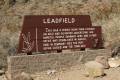
Leadfield – Death Valley National Park


Photo credit The Greater Southwestern Exploration Company, CC BY 2.0. View at https://flic.kr/p/NykbXA
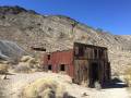
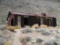
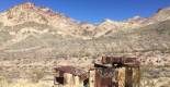
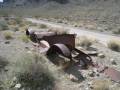
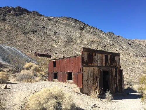
Explore a ghost town deep within the Grapevine Mountains of Death Valley National Park. The area is on the National Register of Historic Places.
| Total Distance: 0.6 miles out & back with spur | Elevation Gain: 181ft. (3,980ft. to 4,034ft.) |
| Difficulty: Easy | 0-5 Mile Difficulty: Easy |
| View Rating: 5.0 out of 5.0 stars | Author’s Rating: 4.0 out of 5.0 stars |
| Visitor Rating: (Click to rate) [Total: 0 Average: 0] | Visitor Difficulty Rating: (Click to rate) [Total: 0 Average: 0] |
| Pets: No | Horses: Yes |
| Best Seasons: November-April | Special Permits: None |
| Water Availability: None | Overnight Options: None |
| Trailhead Amenities: None | Crowd Factor: Solitude |
| Trailhead Access: 1.5 | |
| Uses: | Trail Surface: |
| Features: | Hazards: |
Mile-by-Mile: Leadfield
0.0 Leadfield pullout (4,015ft.). Follow the trail that heads west toward the buildings and slag pile. (36.848314°, -117.059374°)
0.05 Buildings (3,993ft.). Continue left up behind the buildings and along the trail to the top of the slag pile and other buildings. (36.848217°, -117.060416°)
0.1 Top of Slag Pile (4,033ft.). Be sure to look out at views of the mountains to the east – they’re worth seeing. Retrace your steps back down to the first set of buildings and turn left (uphill/north) to follow the trail up the hillside, past some ruins, and on up to more buildings and another slag pile. (36.847869°, -117.060926°)
0.4 Second Slag Pile (4,027ft.). Retrace your steps down the hillside and back to your vehicle. (36.849561°, -117.062163°)
0.6 Leadfield pullout (4,015ft.). (36.848314°, -117.059374°)
History & More
In the early days of the Bullfrog Gold Boom, prospectors discovered lead and copper near where the town of Leadville would be built. Despite the high value of the ore, transportation was too expensive to be profitable. In the mid-1920s, the Western Lead Mine Company and Charles C. Julian once again took up mining in the area. Advertisements to attract investors showed steamboats on the Amargosa River headed for Leadville, despite the fact that the river flows some 20 miles away from the town when it isn’t dry – which is much of the year. C.C. Julian constructed the Titus Canyon Road to give access to his mine, brought in investors, and built several buildings. The town opened a post office in July of 1926, about the time the population reached 300, but it closed within six months as lead deposits ran out, Mr. Julian declared bankruptcy, another investor escaped to Singapore, and the boom town declined.
There are quite a few old buildings and relics left over from the boom days of the town. Explore to your heart’s content, but leave everything – and I mean everything! – exactly as you found it (unless it’s modern trash. You can pack out modern trash).
I wouldn’t personally stay in Leadville very long (and by that I mean more than a few hours). You may also want to wash your body and clothes after visiting. The area has quite a few lead-laced tailings, which could be hazardous over time.
On June 10, 1975, Leadfield was added to the National Register of Historic Places. The paperwork was received on October 30 of that year. The estimated cost for preservation was $900 (about $5,000 in 2022). The reason for significance requiring preservation was listed as “Fraud.”
Download Trail Map
Coming soon!
Driving Directions
Drive the Titus Canyon Road for 15.3 miles from the Daylight Pass Road. Park in the parking area for Leadfield on the right (east) side of the road. You’ll need to cross the road to the west side to get to the trailhead.
It is extremely dangerous to enter a mine due to unstable shafts, gasses, and more. Do not enter mines, even if they are apparently open!
Walking on, climbing, entering, ascending, descending, or traversing any mine, structure, feature, or ruin is prohibited.
Toxic chemicals or ore may be present around mine sites. Enter at your own risk.
Possessing, destroying, injuring, defacing, removing, digging, or disturbing any mine, structure, feature, or ruin is also prohibited.
Leave No Trace Principles are enforced
Drones and model aircrafts are prohibited
Camping is permitted only in designated sites or in areas open to dispersed backcountry camping
All park rules and regulations
12 Month Pass: $55/Death Valley Annual Pass (valid at Death Valley National Park). $80/America the Beautiful Annual Pass (valid at all national park and federal fee areas). $20/Annual Senior Pass (62 years or older US citizens; valid at all national park and federal fee areas). Free/4th Grade Pass (Valid Sept. 1-August 31 of the child’s 4th Grade school year). Free/Military Pass (valid for all active military personel and their dependents with a CAC Card or DD Form 1173).
Lifetime Pass: $80/Lifetime Senior Pass (62 years or older US citizens; valid at all national park and federal fee areas). Free/Access Pass (available to all US citizens with perminent disabilities). Free/Access for Veterans and Gold Star Families Pass (valid for all military and veterans with a CAC card, Veteran HJealth Identification Card, Veteran ID Card, or veteran’s designation on state-issued drivers license or identification card.)
1 thought on “Leadfield – Death Valley National Park”