Slit Canyon – Death Valley National Park


Hike to and up a remote slot canyon in the Funeral Mountains off of Hole in the Wall Road. Some scrambling is required.
| Total Distance: 9.4 miles out & back | Elevation Gain: 3,029ft. (1,891ft. to 4,187ft.) |
| Difficulty: Very Strenuous | 5-10 Mile Difficulty: Extremely Strenuous |
| View Rating: 3.0 out of 5.0 stars | Author’s Rating: 3.0 out of 5.0 stars |
| Visitor Rating: (Click to rate) [Total: 0 Average: 0] | Visitor Difficulty Rating: (Click to rate) [Total: 0 Average: 0] |
| Pets: No | Horses: Yes (likely cannot scramble the dryfalls) |
| Best Seasons: November-April | Special Permits: None |
| Water Availability: None | Overnight Options: Yes; free permit required if you’re near the Hole in the Wall Road |
| Trailhead Amenities: None | Crowd Factor: Solitude |
| Trailhead Access: 1.5 | |
| Uses: | Trail Surface: |
| Features: | Hazards: |
Mile-by-Mile: Slit Canyon Route
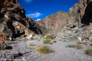
0.0 North side of Hole in the Wall (1,891ft.). Park in the wash on the north (not CA-190) side of the Hole in the Wall formation, where the road turns sharply to the right (east). (If you don’t have high clearance/4×4, you may wish to park on the south side of the formation and walk the short distance to the “trailhead.”) Walk north up the wash. Stay in the main wash, but hug to the center and/or left (west) side to be funneled into Slit Canyon. One side-canyon (Undertaker Canyon) is passed on the right (east) just before mile 1. If you look back, you can see how Hole in the Wall received its name. (36.414876°, -116.723567°)
1.1 Mouth of Slit Canyon (2,343ft.). Continue up the twisting canyon. (36.429171°, -116.719209°)
1.3 First impassable dryfall (2,437ft.). The dryfall is slick and in two drops. Bypass the dryfalls by taking the social trail to the right (east) up and around. The narrows continue after you drop back down into the wash. A few small dryfalls must be negotiated. Arrive at “The Slit” when the route is blocked by a chokestone. Scramble over/around it and continue through the Slit section up to its end – a 10ft. dryfall. Scramble up this to the right. Beyond this, a sheer 50ft. dryfall is the next obstacle. You can opt to turn around here (you’ve seen the best Slit Canyon has to offer) or you can bypass it by scrambling around to the left. The canyon continues to be relatively narrow above this, but it eventually opens up again before narrowing once more about mile 3.9. The canyon widens again. (36.431212°, -116.721365°)
4.7 Wash split (4,187ft.). The canyon only widens after this (the main wash goes left). Most people turn around here or before this, so this guide stops here. (36.457052°, -116.711586°)
History & More
If you don’t have 4×4, you may wish to park just before (south of) the Hole in the Wall. Only drive as far as you’re absolutely certain you can retrace your route back. The road beyond the “parking area” requires 4×4 due to deep gravel and washouts.
You may find people camping in the wash. The Hole in the Wall Road is one of the preferred areas of the park for roadside dispersed camping.
The canyon is named for the slit-like narrows.
There are multiple small dryfalls within the canyon. Be ready for Class 2-Class 3 scrambling.
Download Trail Map
Driving Directions
Take CA-190 to the Hole in the Wall Road. Drive the gravel road up the wash for 3.7 miles to the Hole in the Wall formation. Park out of the way of traffic in the wash just on the other side of the formation. (Note: If you have 2WD, you would be advised to park shortly before passing through the Hole in the Wall and then walk through the formation – the wash on the other side tends to have deep gravel.)
Camping in a canyon is discouraged due to the danger of flash floods.
Remember, it may be easier to climb up dryfalls than down them (or vice versa). Be sure you can climb in the other direction before climbing up or down a dryfall.
Camping is not allowed within one mile of a paved road, developed area, or dirt road that is closed to camping.
Camping is not permitted within 100 feet of a flowing stream, spring, or other natural body of open water.
No camping is permitted on the floor of Death Valley, within one mile of Darwin Falls and Greenwater Canyon, on the active/shifting sand dunes, and certain other canyons and backcountry areas.
Camping is also prohibited within one mile of the Ubehebe Lead Mine, Leadfield Mines, Keane Wonder Mill, and Skidoo Mill.
Camping is limited to 30 days per calendar year within the park.
Fires are permitted in NPS-provided fire grates or grills ONLY.
Leave No Trace Principles are enforced
Drones and model aircrafts are prohibited
Camping is permitted only in designated sites or in areas open to dispersed backcountry camping
All park rules and regulations
12 Month Pass: $55/Death Valley Annual Pass (valid at Death Valley National Park). $80/America the Beautiful Annual Pass (valid at all national park and federal fee areas). $20/Annual Senior Pass (62 years or older US citizens; valid at all national park and federal fee areas). Free/4th Grade Pass (Valid Sept. 1-August 31 of the child’s 4th Grade school year). Free/Military Pass (valid for all active military personel and their dependents with a CAC Card or DD Form 1173).
Lifetime Pass: $80/Lifetime Senior Pass (62 years or older US citizens; valid at all national park and federal fee areas). Free/Access Pass (available to all US citizens with perminent disabilities). Free/Access for Veterans and Gold Star Families Pass (valid for all military and veterans with a CAC card, Veteran HJealth Identification Card, Veteran ID Card, or veteran’s designation on state-issued drivers license or identification card.)