
Titanothere Canyon to Lostman Spring – Death Valley National Park


Hike down a remote desert canyon to a spring.
| Total Distance: 8.5 miles out & back | Elevation Gain: 2,069t. (4,997ft. to 3,046ft.) |
| Difficulty: Strenuous | 0-5 Mile Difficulty: Very Strenuous |
| View Rating: 3.0 out of 5.0 stars | Author’s Rating: 2.0 out of 5.0 stars |
| Visitor Rating: (Click to rate) [Total: 0 Average: 0] | Visitor Difficulty Rating: (Click to rate) [Total: 0 Average: 0] |
| Pets: No | Horses: Yes |
| Best Seasons: November-April | Special Permits: None |
| Water Availability: No potable water | Overnight Options: After 2.0 miles (no camping within 100 yards of the spring) |
| Trailhead Amenities: None | Crowd Factor: Solitude |
| Trailhead Access: 1.5 | |
| Uses: | Trail Surface: |
| Features: | Hazards: |
Mile-by-Mile: Titanothere Canyon to Lostman Spring
0.0 Titanothere Canyon First Trailhead on the Titus Canyon Road (4,997ft.). This is the first trailhead for Titanothere Canyon (the second trailhead is 1.1 miles down the road – either wash will bring you into Titanothere Canyon; however, this trailhead purportedly has the better views while the second trailhead is less brushy and requires less scrambling). Walk south down the wash into the mountains. The wash is brushy; long pants are recommended. (36.828949°, -117.008037°)
0.25 Dryfall/Canyon Split (4,886ft.). To bypass the 80ft. dryfall, turn right (west) to work your way around the cliffs and down into the lower part of Titanothere Canyon. From here, the canyon winds downward through the mountains. About mile 1, the wash passes through a short set of narrows. (36.826198°, -117.010352°)
1.1 Drop into Titanothere Canyon (4,311ft.). Turn left (south) to continue down Titanothere Canyon, which broadens with expansive views, including Thimble Peak to the west. A dinosaur skull was found in Titanothere Canyon in 1933. Around mile 2.7, keep your eyes open for a sidecanyon on the left (east; 36.798255°, -117.019125°) – just before this you can see a couple of small arches on the eastern skyline. This area also has some very interesting dark-colored pinnacles. Just after the confluence, you may find a semicircle of stones and various historical junk. About mile 4, you’ll pass between two cliffs on either side of the canyon. Michel Digonnet calls this “the Neck,” a 50ft. wide passage through which the wash flows. After this, hug the southern/eastern (left) side of the wash. (36.817928°, -117.016177°)
4.2 Turn left to Lostman Spring (3,048ft.). Scramble left up the east side of the canyon. Push through the bushes to the spring. (36.784311°, -117.032035°)
4.25 Lostman Spring (3,085ft.). This is the turn-around point for most hikers. If you would like to continue down Titanothere Canyon, the canyon mouth is at mile 8.1 and Scotty’s Castle Road, mile 11.2 (arrange for a shuttle ride so you don’t have to hike all of the way back up the canyon!) (36.783978°, -117.031674°)
History & More
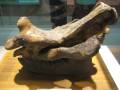
In 1933, a dinosaur head fossil was found in Titanothere Canyon. A Titanothere is a group of extinct dinosaurs similar to a modern rhinoceros. Scientists tell us that the animals moved in herds eating soft vegetation. The technical term for a Titanothere is a Brontotheres.
A second Titanothere fossil was found near Titus Canyon; however, it was not as well-preserved as the first fossil and included little more than the teeth of the giant animal.
Specifically, the fossil found in Titanothere Canyon included the skull and jaws of the dinosaur. The teeth were small and oval, nose (nasals) long and broad, and horns large and oval that protruded outward and upward. The specific species was named for H. Donald Curry, who found the fossil.
Interestingly, the Tianothere skull found in Titanothere Canyon was the largest of its kind found in North America up to that time.
There is no trail down Titanothere Canyon. Be wary of changing conditions, and don’t do anything foolhardy. Follow the lay of the land rather than the map, directions, or GPS file.
Many springs were named for events surrounding their discovery or physical features. It’s to be guessed that Lostman Spring was named by a party searching for a lost man or else for the lost man who was found near the spring.
The spring rarely has visible water – but the trees and other foliage ensure you’ll know where it is!
Download Trail Map
Coming soon!
Driving Directions
From the Daylight Pass Road, drive 9.9 miles down the Titus Canyon Road. Park near where the road crosses the Titanothere Canyon wash for the first time. Be certain not to obstruct traffic, and also don’t drive off-road.
Camping in a canyon is discouraged due to the danger of flash floods.
Remember, it may be easier to climb up dryfalls than down them (or vice versa). Be sure you can climb in the other direction before climbing up or down a dryfall.
Camping is not allowed within one mile of a paved road, developed area, or dirt road that is closed to camping.
Camping is not permitted within 100 feet of a flowing stream, spring, or other natural body of open water.
No camping is permitted on the floor of Death Valley, within one mile of Darwin Falls and Greenwater Canyon, on the active/shifting sand dunes, and certain other canyons and backcountry areas.
Camping is also prohibited within one mile of the Ubehebe Lead Mine, Leadfield Mines, Keane Wonder Mill, and Skidoo Mill.
Camping is limited to 30 days per calendar year within the park.
Fires are permitted in NPS-provided fire grates or grills ONLY.
Leave No Trace Principles are enforced
Drones and model aircrafts are prohibited
Camping is permitted only in designated sites or in areas open to dispersed backcountry camping
All park rules and regulations
12 Month Pass: $55/Death Valley Annual Pass (valid at Death Valley National Park). $80/America the Beautiful Annual Pass (valid at all national park and federal fee areas). $20/Annual Senior Pass (62 years or older US citizens; valid at all national park and federal fee areas). Free/4th Grade Pass (Valid Sept. 1-August 31 of the child’s 4th Grade school year). Free/Military Pass (valid for all active military personel and their dependents with a CAC Card or DD Form 1173).
Lifetime Pass: $80/Lifetime Senior Pass (62 years or older US citizens; valid at all national park and federal fee areas). Free/Access Pass (available to all US citizens with perminent disabilities). Free/Access for Veterans and Gold Star Families Pass (valid for all military and veterans with a CAC card, Veteran HJealth Identification Card, Veteran ID Card, or veteran’s designation on state-issued drivers license or identification card.)
2 thoughts on “Titanothere Canyon to Lostman Spring – Death Valley National Park”