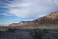
Willow Canyon – Death Valley National Park


H ike up a desert canyon to a small slot and a seasonal waterfall.
| Total Distance: 4.4 miles out & back | Elevation Gain: 1,325ft. (-236ft. to 615ft.) |
| Difficulty: Moderately Strenuous | 0-5 Mile Difficulty: Very Strenuous |
| View Rating: 3.0 out of 5.0 stars | Author’s Rating: 2.0 out of 5.0 stars |
| Visitor Rating: (Click to rate) [Total: 0 Average: 0] | Visitor Difficulty Rating: (Click to rate) [Total: 0 Average: 0] |
| Pets: No | Horses: No |
| Best Seasons: December-May | Special Permits: None |
| Water Availability: Seasonal (non-potable) | Overnight Options: Dispersed camping permitted after about the 1.25 mile point (1 mile from the Badwater Road) |
| Trailhead Amenities: None | Crowd Factor: Moderate |
| Trailhead Access: 1.3 | |
| Uses: | Trail Surface: |
| Features: | Hazards: |
Mile-by-Mile: Willow Canyon Trail
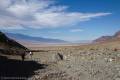
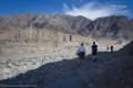
0.0 Willow Canyon Trailhead (-236ft.). The unmarked trail begins by striking northeast along the base of the hill (it’s pretty hard to miss). (Be careful to get the trail that heads north (with the Badwater Road on your left) – the trail heading south is for Sidewinder Canyon.) Once it reaches the wash just before mile 0.5, it turns right (southeast) to travel upcanyon. Social trails dot the wash; you’re welcome to follow any of these that stay in the wash. (36.0659167°, -116.7445167°)
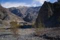
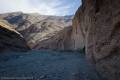
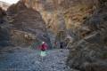
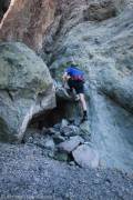
1.8 Canyon Junction (378ft.). Stay in the main canyon by continuing straight/left into the narrows of Lower Willow Canyon. In the right season (after a rain, usually, or after the winter snow melts) you’ll begin seeing water through the gravel on the floor of the canyon soon after entering the narrows. One short (6ft.) dryfall must be negotiated to get higher into the canyon – helpful hikers have stacked rocks to make it a fairly easy Class 3 scramble. (36.055402°, -116.724270°)
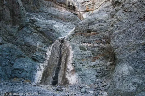
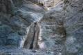
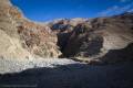
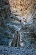
2.2 Willow Falls (615ft.). The waterfall is dry most of the year, but it’s pretty with or without water on it. Retrace your steps to your vehicle. (36.0527833°, -116.7189667°)
History & More
Willow Creek is seasonal, which means that the falls may or may not have water on them. Usually, the falls flow in the spring and winter, when rain and snow in the mountains are more frequent. When flowing, the creek creates several pools and cascades below the main waterfall.
I’ve heard that the top of Willow Falls can be accessed from the 4×4 Gold Valley Road. However, ropes are required to repel down – and climb back up – several dryfalls.
The rocks around the falls are igneous, which means that they were formed when molten lava hardened.
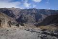
If you want to explore the drainage you didn’t turn right into just before the narrows, I hear that you can do so as well as scramble up above the canyon for some good views down on Death Valley. The hillsides are notoriously unstable, so watch your footing.
If you want to find a waterfall that is sure to be there all year, head up to Darwin Falls in the western part of the park.
Download Trail Map
Driving Directions
From the Furnace Creek Visitor Center, drive south on CA-190E (a right turn if you’re coming out of the visitor center access road). After 1.3 miles, turn right onto the Badwater Road, following signs for Badwater. Drive 31.3 miles; a sign will indicate the Sidewinder Trailhead on the left (east). This is also the parking area for Willow Canyon, though you’ll want to head to the left (north) side of the gravel lot to park.
From Death Valley Junction, take CA-190 West 28.9 miles to the Badwater Road; turn left toward Badwater. After 31.3 miles; a sign will indicate the Sidewinder Trailhead on the left (east). This is also the parking area for Willow Canyon, though you’ll want to head to the left (north) side of the gravel lot to park.
From CA-127 north of Shoshone, turn onto the Jubilee Pass Road. Drive 24.9 miles, then take the paved road as it turns sharply north at the junction for the Harry Wade Road and drive for another 14.5 miles on the Badwater Road to the Sidewinder Trailhead, on the right (east). This is also the parking area for Willow Canyon, though you’ll want to head to the left (north) side of the gravel lot to park. Note that there’s no sign from this side, but it’s quite soon after passing Mormon Point, which is signed
The parking area is gravel, but it should be passable by low-clearance vehicles under most circumstances.
Camping in a canyon is discouraged due to the danger of flash floods.
Remember, it may be easier to climb up dryfalls than down them (or vice versa). Be sure you can climb in the other direction before climbing up or down a dryfall.
Camping is not allowed within one mile of a paved road, developed area, or dirt road that is closed to camping.
Camping is not permitted within 100 feet of a flowing stream, spring, or other natural body of open water.
No camping is permitted on the floor of Death Valley, within one mile of Darwin Falls and Greenwater Canyon, on the active/shifting sand dunes, and certain other canyons and backcountry areas.
Camping is also prohibited within one mile of the Ubehebe Lead Mine, Leadfield Mines, Keane Wonder Mill, and Skidoo Mill.
Camping is limited to 30 days per calendar year within the park.
Fires are permitted in NPS-provided fire grates or grills ONLY.
Leave No Trace Principles are enforced
Drones and model aircrafts are prohibited
Camping is permitted only in designated sites or in areas open to dispersed backcountry camping
All park rules and regulations
12 Month Pass: $55/Death Valley Annual Pass (valid at Death Valley National Park). $80/America the Beautiful Annual Pass (valid at all national park and federal fee areas). $20/Annual Senior Pass (62 years or older US citizens; valid at all national park and federal fee areas). Free/4th Grade Pass (Valid Sept. 1-August 31 of the child’s 4th Grade school year). Free/Military Pass (valid for all active military personel and their dependents with a CAC Card or DD Form 1173).
Lifetime Pass: $80/Lifetime Senior Pass (62 years or older US citizens; valid at all national park and federal fee areas). Free/Access Pass (available to all US citizens with perminent disabilities). Free/Access for Veterans and Gold Star Families Pass (valid for all military and veterans with a CAC card, Veteran HJealth Identification Card, Veteran ID Card, or veteran’s designation on state-issued drivers license or identification card.)
2 thoughts on “Willow Canyon – Death Valley National Park”