Lowest Point in North America – Death Valley National Park


Discover the lowest point in North America, deep in the salt flats of Badwater Basin.
| Total Distance: 7.0 miles out & back | Elevation Gain: 212ft. (-270ft. to -282ft.) |
| Difficulty: Moderate | 5-10 Mile Difficulty: Moderate |
| View Rating: 5.0 out of 5.0 stars | Author’s Rating: 4.0 out of 5.0 stars |
| Visitor Rating: (Click to rate) [Total: 0 Average: 0] | Visitor Difficulty Rating: (Click to rate) [Total: 0 Average: 0] |
| Pets: No | Horses: No |
| Best Seasons: November-April; impassable when wet | Special Permits: None |
| Water Availability: None | Overnight Options: None unless you continue to the roads off of the West Side Road, where dispersed camping is allowed after one mile |
| Trailhead Amenities: Primitive Restroom | Crowd Factor: Solitude beyond Badwater Basin |
| Trailhead Access: 0.6 | |
| Uses: | Trail Surface: |
| Features: | Hazards: |
Mile-by-Mile: Lowest Point in North America
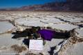
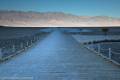
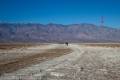
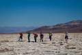
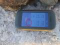
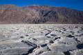
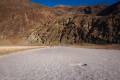
0.0 Badwater Basin Trailhead (-270ft.). Walk either right or left to the stairs to descend down the boardwalk that goes out to the salt flats. Follow the trail out across the salt flats to where the trail more or less ends in the vast whiteness/brown of the flats. After the trail ends, strike out generally toward the GPS coordinates for the Lowest Point in North America (see below). We headed for two small peaks on the ridgeline as guides (see the photo). The tread is not easy walking; ridges in the salt flats must be stepped over almost constantly (don’t wreck the beauty of the salt flats by stepping on the ridges). The ridges often contain small salt arches, salt bubbles, or other interesting features. Depending on current conditions, some parts of the salt flats will be pure white, and others will be brown. This is normal. If an area is wet, do not step there – your footprints might last a very, very long time before being washed away. (36.229783°, -116.767435°)
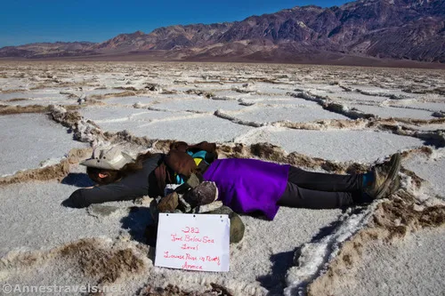
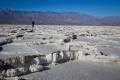
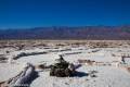
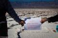
3.5 Lowest Point in North America (-282ft.). A small cairn marks the lowest point. Congratulations! You can continue from here to finish crossing Death Valley by heading for the vegetation on the western side of the salt flats (tacking on the Lowest Point in North America adds about 1 mile to the crossing mileage) or you can retrace your steps to Badwater Basin. (36.2419167°, -116.8255500°)
History & More
Badwater Basin is about 2 feet higher than the actual lowest point in North America. So it only makes sense that you’d want to seek out the real lowest place in North America, right?
There are actually several places on the Badwater Salt Flats that are -282ft. below sea level. This is just one of them.
Despite what I was told when we visited Death Valley in the 2000s, the lowest point in the Western Hemisphere is Laguna Del Carbon (English: Coal Lagoon) in Argentina at -344ft. below sea level. The lowest point in the world (at least on dry land) is the Dead Sea at -1,401ft. below sea level on the border of Israel and Jordan.
It’s said that Badwater Flats received its name from Badwater Basin. A miner tried to drink the water from the pool near the boardwalk, but the water was so salty that he couldn’t drink it.
The ridges of salt are created as water seeps up through the salt flats and evaporates.
The salt flats are mostly made up of sodium chloride (which is just table salt), though there is also calcite, gypsum, and borax on the flats. Don’t fall down – that salt is sharp!
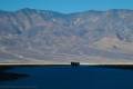
Badwater Flats cover nearly 200 square miles on the floor of Death Valley.
Download Trail Map
Driving Directions
From the Furnace Creek Visitor Center, head south on CA-190E (a right turn if you’re coming out of the visitor center access road). After 1.3 miles, turn right onto the Badwater Road, following signs for Badwater. Drive 16.5 miles to the parking area for Badwater Basin, on right.
From Death Valley Junction, take CA-190 West 28.9 miles to the Badwater Road; turn left toward Badwater. After 16.5 miles, turn right into the Badwater Basin parking area.
From the south, drive north on the Badwater Road. Badwater Basin is on the left about 30 miles north of Ashford Junction, where the Harry Wade Road joints the Jubilee Pass Road to become the Badwater Road.
Leave No Trace Principles are enforced
Drones and model aircrafts are prohibited
Camping is permitted only in designated sites or in areas open to dispersed backcountry camping
Click here for all park rules and regulations
12 Month Pass: $55/Death Valley Annual Pass (valid at Death Valley National Park). $80/America the Beautiful Annual Pass (valid at all national park and federal fee areas). $20/Annual Senior Pass (62 years or older US citizens; valid at all national park and federal fee areas). Free/4th Grade Pass (Valid Sept. 1-August 31 of the child’s 4th Grade school year). Free/Military Pass (valid for all active military personel and their dependents with a CAC Card or DD Form 1173).
Lifetime Pass: $80/Lifetime Senior Pass (62 years or older US citizens; valid at all national park and federal fee areas). Free/Access Pass (available to all US citizens with perminent disabilities). Free/Access for Veterans and Gold Star Families Pass (valid for all military and veterans with a CAC card, Veteran HJealth Identification Card, Veteran ID Card, or veteran’s designation on state-issued drivers license or identification card.)
1 thought on “Lowest Point in North America – Death Valley National Park”