Coffin Peak – Death Valley National Park


Take a short but trailless hike to a mountain peak with fantastic views of the Black, Greenwater, Panamin, and Funeral Mountains.
| Total Distance: 2.5 miles out & back | Elevation Gain: 919ft. (5,117ft. to 5,507ft.) |
| Difficulty: Moderate | 0-5 Mile Difficulty: Moderately Strenuous |
| View Rating: 5.0 out of 5.0 stars | Author’s Rating: 4.0 out of 5.0 stars |
| Visitor Rating: (Click to rate) [Total: 0 Average: 0] | Visitor Difficulty Rating: (Click to rate) [Total: 0 Average: 0] |
| Pets: No | Horses: Yes |
| Best Seasons: October-May | Special Permits: None |
| Water Availability: None | Overnight Options: None |
| Trailhead Amenities: Restrooms | Crowd Factor: Solitude |
| Trailhead Access: 0.7 | |
| Uses: | Trail Surface: |
| Features: | Hazards: |
Mile-by-Mile: Coffin Peak Route
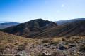
0.0 Unmarked Trailhead (5,178ft.). Park in the trailer parking lot near the restrooms below Dantes View. Begin at the wilderness sign; turn left immediately to start trekking east via the wash until the wash takes a sharp right turn to the south after about a quarter mile. From here, turn left to begin climbing up to the ridgeline by continuing in an easterly direction. You may find a vague trail or a few cairns. Continue as the ridgeline twists and turns, occasionally skirting or walking over small peaks. As the route reaches the final ridgeline that travels east to Coffin Peak, a defined trail appears. Follow this route. (36.217759°, -116.722197°)
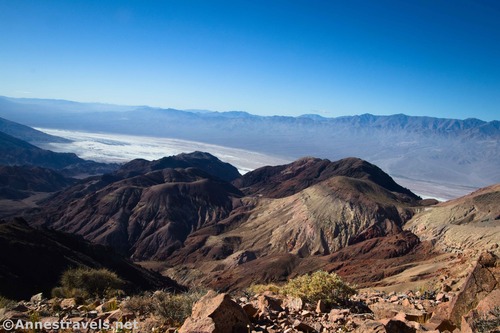
1.25 Coffin Peak (5,506ft.). Enjoy views in all directions, including to the Panamint Mountains (west), down toward Badwater Flats (also west), down Coffin Canyon and into the Black Mountains (south), east into Greenwater Valley, north into the Funeral Mountains, and to nearby peaks and valleys. Mt. Perry is also visible as a colorful peak to the northwest. (36.214368°, -116.705727°)
History & More
As you walk along the ridgeline, enjoy views to Dantes View Peak and Perry Peak, Badwater Basin, the Panamint Mountains, Pyramid Peak and other summits of the Funeral Mountains, Charleston Peak far to the east in Nevada, and many summits in the Black Mountains and Greenwater Range.
I don’t know how Coffin Peak received its name, but chances are that explorers or settlers thought the ridgeline looked like a coffin. Funerals were common in those days, in part because mourning services were community events. So everyone knew what a coffin looked like. Besides, who wouldn’t want to have a Coffin Peak in the Black Mountains of Death Valley overlooking the Funeral Mountains?
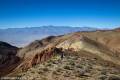
Coffin Peak is relatively unvisited. By following the ridgeline, you can expect nothing worse than Class 2 scrambling, though other faces of the peak are a bit more “fun.” One part of the trek is over some sketchy scree, so use caution.
Download Route Map
Driving Directions
Take CA-190 east of Furnace Creek. The turn onto Dantes View Road is 18.1 miles west of Death Valley Junction (0.4 miles west of the fee kiosk) and 10.7 miles east of the Badwater Road Junction. Drive 12.6 miles up the Dantes View Road to the Trailer Parking/restroom on the left (south) side of the road. Park here.
Leave No Trace Principles are enforced
Drones and model aircrafts are prohibited
Camping is permitted only in designated sites or in areas open to dispersed backcountry camping
Click here for all park rules and regulations
12 Month Pass: $55/Death Valley Annual Pass (valid at Death Valley National Park). $80/America the Beautiful Annual Pass (valid at all national park and federal fee areas). $20/Annual Senior Pass (62 years or older US citizens; valid at all national park and federal fee areas). Free/4th Grade Pass (Valid Sept. 1-August 31 of the child’s 4th Grade school year). Free/Military Pass (valid for all active military personel and their dependents with a CAC Card or DD Form 1173).
Lifetime Pass: $80/Lifetime Senior Pass (62 years or older US citizens; valid at all national park and federal fee areas). Free/Access Pass (available to all US citizens with perminent disabilities). Free/Access for Veterans and Gold Star Families Pass (valid for all military and veterans with a CAC card, Veteran HJealth Identification Card, Veteran ID Card, or veteran’s designation on state-issued drivers license or identification card.)