
Mount Perry – Death Valley National Park


Enjoy wide views from Dante’s Ridge on your way up Mt. Perry, with 360 degree views to surrounding mountains, valleys, salt flats, and much more.
| Total Distance: 9.0 miles out & back | Elevation Gain: 3,033ft. (4,930ft. to 5,738ft.) |
| Difficulty: Very Strenuous | 5-10 Mile Difficulty: Extremely Strenuous |
| View Rating: 5.0 out of 5.0 stars | Author’s Rating: 4.0 out of 5.0 stars |
| Visitor Rating: (Click to rate) [Total: 0 Average: 0] | Visitor Difficulty Rating: (Click to rate) [Total: 0 Average: 0] |
| Pets: No | Horses: No |
| Best Seasons: October-May | Special Permits: None |
| Water Availability: None | Overnight Options: None |
| Trailhead Amenities: Restrooms 0.6 miles down the road | Crowd Factor: Moderate |
| Trailhead Access: 0.7 | |
| Uses: | Trail Surface: |
| Features: | Hazards: |
Mile-by-Mile: Mount Perry Trail
0.0 Dantes View Trailhead (5,475ft.). Walk north (right if you’re facing the view down on Badwater Flats) on the well-defined trail along the ridgeline. Views are excellent both down on Death Valley/across to the Panamint Mountains and down into the Black Mountains (to the right). Other routes may strike off of the main trail en route up to Dante’s View Peak. (36.220576°, -116.726783°)
0.4 Dantes View Peak (5,699ft.). Enjoy the views before beginning the descent along the ridgeline. The trail descends 1.1 miles to a saddle above Bad Canyon, then spends 1.4 miles traveling over four small summits before beginning a scrambling ascent up Mt. Perry. After passing below Point 5235 about mile 2, the path crosses a boulder field; follow the cairns as you scramble across the rocks. The trail sometimes follows the ridgeline and sometimes travels close to it; other times, it wraps around the small summits on the ridgeline. The final 0.75 miles of the trail are also over rocks – this time, follow the straight, narrow ridge to the mountain peak. (36.226302°, -116.725623°)
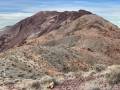
4.5 Mount Perry (5,737ft.). Enjoy 360 degree views of the surrounding mountains and valleys, including Badwater Flats and the Panamint Range, the Funeral Mountains (north), Greenwater Valley and the ghost town of Ryan, the Black Mountains (south and surrounding), and much, much more. (36.273612°, -116.724517°)
History & More
The trail to Mt. Perry is unmarked. However, it’s well-known to the National Park Service; they even offer a trail guide for it on their website (and also likely at the visitor center).
Many hikers choose to turn around at Dante’s View Peak for a 0.8 mile round trip hike. You’ll have seen fantastic views, so if it’s hot or you just don’t want a longer trek, it’s a great option.
Dante’s View – and the Dante’s Ridge Trail – is much higher than the valley floor. In summer, the trail is still very exposed and oppressively hot – but not quite so hot as Badwater Basin. In winter, the trail may be very cold or even snowy (in fact, the road to the trailhead sometimes closes due to ice and snow). Bring layers and be prepared for winter hiking if hiking December-February.
The trail is narrow at times with steep dropoffs. It’s not the best trail for those with vertigo, though if you’re used to hiking in the mountains you should be fine. The dropoffs are less after Dantes View Peak but begin again in earnest in the scramble section.
As you hike along the ridge, you’ll probably see four canyons across the valley at the base of the Panamint Mountains. These are (R-L/N-S) Trail Canyon, Hanaupah Canyon, Johnson Canyon, and Galena Canyon. You can also see Telescope Peak (the highest point in the range as well as in Death Valley National Park) and Wildrose Peak.
Looking to the east, you get some great views to Pyramid Peak and the Funeral Mountains, down into Greenwater Valley (from near Mt. Perry) and the Black Mountains. Further away, views extend to the Mt. Charleston Wilderness and the entirety of the Spring Mountains.
I’ve heard that this is a great sunrise hike with spectacular views of the rising sun and first light on the valley below.
Download Route Map
Driving Directions
Take CA-190 east of Furnace Creek. The turn onto Dantes View Road is 18.1 miles west of Death Valley Junction (0.4 miles west of the fee kiosk) and 10.7 miles east of the Badwater Road Junction. Drive 13.2 miles up to the end of the Dantes View Road.
Leave No Trace Principles are enforced
Drones and model aircrafts are prohibited
Camping is permitted only in designated sites or in areas open to dispersed backcountry camping
Click here for all park rules and regulations
12 Month Pass: $55/Death Valley Annual Pass (valid at Death Valley National Park). $80/America the Beautiful Annual Pass (valid at all national park and federal fee areas). $20/Annual Senior Pass (62 years or older US citizens; valid at all national park and federal fee areas). Free/4th Grade Pass (Valid Sept. 1-August 31 of the child’s 4th Grade school year). Free/Military Pass (valid for all active military personel and their dependents with a CAC Card or DD Form 1173).
Lifetime Pass: $80/Lifetime Senior Pass (62 years or older US citizens; valid at all national park and federal fee areas). Free/Access Pass (available to all US citizens with perminent disabilities). Free/Access for Veterans and Gold Star Families Pass (valid for all military and veterans with a CAC card, Veteran HJealth Identification Card, Veteran ID Card, or veteran’s designation on state-issued drivers license or identification card.)