Dantes View Road – Death Valley National Park


Drive up a paved road to a spectacular viewpoint over Death Valley.
| Total Distance: 13.2 miles point to point (dead end) | Elevation Gain: 3,528ft. up, 48ft. down (1,989ft. to 5,480ft.) |
| Road Difficulty: 0.7 | Bicycle Difficulty: Easy |
| View Rating: 3.0 out of 5.0 stars | Rating: 3.0 out of 5.0 stars |
| Visitor Rating: (Click to rate) [Total: 0 Average: 0] | Visitor Difficulty Rating: (Click to rate) [Total: 0 Average: 0] |
| Pets: Yes | Horses: No |
| Best Seasons: October-May | Special Permits: None |
| Water Availability: None | Overnight Options: None |
| Amenities: Primitive restrooms 0.6 miles below Dantes View | Crowd Factor: Moderate to Crowded |
| Uses: | Road Surface: |
| Features: | Hazards: |
Mile-by-Mile: Dantes View Road
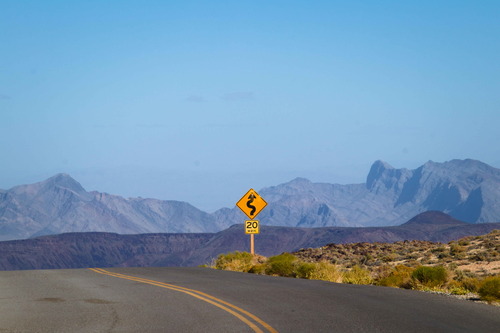
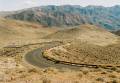
0.0 Beginning of Dantes View Road on CA-190 (2,000ft.). Drive south up Dantes View Road. The views are excellent to colorful hills in the Black Mountains. About mile 1.4, pass a gated road to the old Boraxo Mine Site. Continue on the paved road. Pass another old road on the left about a mile later. The road works its way up a small canyon (part of the Furnace Creek Wash) before entering a broad plain in the mountains. (36.363071°, -116.709177°)
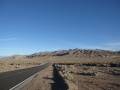
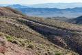
7.5 Greenwater Valley Road on left (east) (3,230ft.). The dirt Greenwater Valley Road goes off with a sign that tells you Shoshone is in 36 (miles). A paved parking area is on the right directly across the road. A gate just beyond the junction can be closed if Dantes View is inaccessible. Continue straight (southwest) on the paved road. The road ascends across the broad plain, working its way southwest and into the higher peaks of the Black Mountains. About mile 12, pass an old road (now only open to horse and foot traffic) on the right. (36.268580°, -116.663770°)
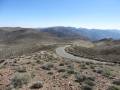
12.6 Trailer parking/restroom on left (south) (5,182ft.). This is as far as trailers are allowed to go; parking is available near the restroom (note that there is no restroom at the main parking lot, higher up the hill). Non-trailers can continue up the winding road to the the main lot. (36.217854°, -116.722250°)
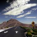
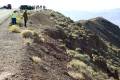
13.2 Dantes View Parking Area (5,480ft.). The viewpoint is on the right (west). You can also access the trailheads for Dantes View and Mount Perry. (36.220706°, -116.726602°)
History & More
In 1971, Tenneco, Inc., opened the Boraxo Mine near the Dantes View Road. The pit mine was sunk 400ft. before public outcry prompted Congress to pass the Mining in the Parks Act in 1976, closing Death Valley National Monument to future mining operations. Four years later, some mining resumed, including the Billie Mine, which was the only active mine in the park until it closed down in 2005.
The Mining in the Parks Act of 1976 required the National Park Service to reevaluate the validity of all of the potential mining claims in the park. Even when the evaluation was over, valid mining claims were required to be run with much stricter environmental standards.
Even with the refusal of mines to be operated within Death Valley, some mining areas are still privately held and closed to the public. Often, they’re only vaguely signed, and they rarely appear on park maps. So be careful to obey all signage and not to stumble onto private property as best as you can.
The Dante’s View Road may close after storms that bring mud down on the road or in winter when snow and ice pose a threat to motorists. Please respect the closed roads, as the park service is often working overtime to reopen it and other roads in the park to motorists and visitors alike.
Download Road Map
Driving Directions
Take CA-190 east of Furnace Creek. The turn onto Dantes View Road is 18.1 miles west of Death Valley Junction (0.4 miles west of the fee kiosk) and 10.7 miles east of the Badwater Road Junction.
Leave No Trace Principles are enforced
Drones and model aircrafts are prohibited
Camping is permitted only in designated sites or in areas open to dispersed backcountry camping
Click here for all park rules and regulations
12 Month Pass: $55/Death Valley Annual Pass (valid at Death Valley National Park). $80/America the Beautiful Annual Pass (valid at all national park and federal fee areas). $20/Annual Senior Pass (62 years or older US citizens; valid at all national park and federal fee areas). Free/4th Grade Pass (Valid Sept. 1-August 31 of the child’s 4th Grade school year). Free/Military Pass (valid for all active military personel and their dependents with a CAC Card or DD Form 1173).
Lifetime Pass: $80/Lifetime Senior Pass (62 years or older US citizens; valid at all national park and federal fee areas). Free/Access Pass (available to all US citizens with perminent disabilities). Free/Access for Veterans and Gold Star Families Pass (valid for all military and veterans with a CAC card, Veteran HJealth Identification Card, Veteran ID Card, or veteran’s designation on state-issued drivers license or identification card.)