Greenwater Valley Road – Death Valley National Park


Follow a high-clearance-required dirt road between the Greenwater Range and the Black Mountains to access historic and beautiful sites.
| Total Distance: 28.3 miles point-to-point | Elevation Gain: 897ft. up, 2,026ft. down (2,101ft. to 4,060ft.) |
| Road Difficulty: 1.5 (high clearance recommended due to washboard) | Bicycle Difficulty: More Difficult |
| View Rating: 3.0 out of 5.0 stars | Author’s Rating: 2.0 out of 5.0 stars |
| Visitor Rating: (Click to rate) [Total: 0 Average: 0] | Visitor Difficulty Rating: (Click to rate) [Total: 0 Average: 0] |
| Pets: Leashed | Horses: Yes |
| Best Seasons: October-May | Special Permits: Only for camping |
| Water Availability: None | Overnight Options: Yes with free permit; no camping permitted within 1 mile of either end of the road |
| Amenities: None | Crowd Factor: Solitude to Moderate |
| Uses: | Road surface: |
| Features: | Hazards: |
Mile-by-Mile: Greenwater Valley Road
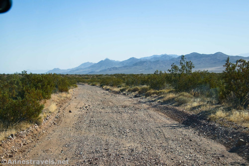
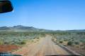
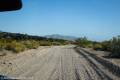
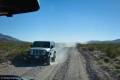
0.0 Greenwater Valley Road on the Dante’s View Road (3,231ft.). The dirt Greenwater Valley Road goes off with a sign that tells you Shoshone is in 36 (miles). A paved parking area is located directly across the Dante’s View Road. Turn south onto the Greenwater Valley Road, which strikes southeast across the greasebrush-infested plain, hemmed in by hills on both sides. Be prepared to drive slowly and navigate washboard. (36.268580°, -116.663770°)
2.8 Furnace Townsite Road on right (west) (3,480ft.). The sideroad leads up to the Furnace Townsite. Continue left (straight/south) on the main dirt road. (Note: A network of dirt roads in this area will take you to the Greenwater Town Site, as well.) Pass a sideroad, also on the right (west) about mile 5.5. (36.235353°, -116.637157°)
5.8 Greenwater Townsite Road on right (west) (3,733ft.). This is one of two roads that lead to the Greenwater Townsite. Continue south (straight) on the main road. (36.201757°, -116.603069°)
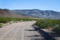
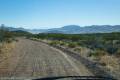
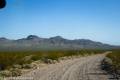
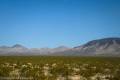
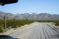
8.4 Greenwater Townsite Road on right (west) (3,880ft.). This is the second of the two roads that lead to the Greenwater Townsite. Continue south (straight) on the main road. A road goes off on the left (east) a tenth of a mile later. The main road continues through Greenwater Valley with occasional old mining roads going off to the east. Views continue to be good to the mountains on either side of the valley. (36.170867°, -116.577234°)
17.7 Gold Valley Road on right (west) (3,093ft.). This is the road to Gold Valley (4×4 is required to drive into the valley). Continue straight (southeast) on the main road. (36.055750°, -116.507392°)
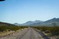
18.2 Deadman Pass Road on left (northeast) (3,001ft.). This is the Deadman Pass Road, which is 4×4 only after the pass. Continue south on the main road. The washboard after this junction abates a bit, though you should still take it slow. A few old roads may go off on the left (east); ignore them. About mile 21.5, you’ll begin to follow a wash southward, crossing the wash to the north bank about mile 21.8. A prominent road (to a campsite) strikes north about mile 25.2. (36.050658°, -116.500158°)
28.3 Jubilee Pass Road (2,101ft.). Driving 5.8 miles left (east) will bring you to CA-127 just north of Shoshone and south of Death Valley Junction; driving 19.2 miles right (west) will bring you to the north end of the Harry Wade Road and the south end of the Badwater Road. (35.966360°, -116.363601°)
History & More
Like many roads in Death Valley, the Greenwater Valley Road was created by miners and prospectors. The area saw several mining booms in the early 1900s, especially 1905-1908.
While much of the road has severe washboard, the northernmost two miles are the worst. 4×4 is not required, but you’ll want to have high clearance due to the washboard. The southernmost section of the road is the smoothest per the National Park Service, though it depends on recent maintenance.
Park maps call this the Greenwater Valley Road; however, its official name is also the Furnace Creek Wash Road – which is what you’ll see on many non-NPS maps. However, this is confusing, as there is also a Furnace Creek Wash Road just to the south, on the other side of the Jubilee Pass Road – though the two “Furnace Creek Wash Roads” don’t seem to connect.
Be careful of the numerous washes along the road, especially during spring runoff and summer monsoon season. Do not enter a wash with water in it.
The best time to visit Greenwater Valley is in the early spring when flowers fill the valley with splashes of color.
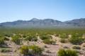
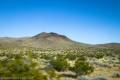
Greenwater Valley is filled with basalt lava flows. It’s higher in elevation than much of the park (mostly above 3,000ft.) but it’s still brutally hot out on the lava in the summer.
Greenwater Valley is surrounded by mountains. To the east is the Greenwater Range, and to the west is the Black Mountains.
Download Route Map
Driving Directions
The Greenwater Valley Road stretches between Dante’s View Road in the north and Jubilee Pass Road in the south. To get to the north end, take the Dante’s View Road 7.5 miles from CA-190; turn left onto the gravel road. To access the south end, take the Jubilee Pass Road 5.8 miles west from CA-127; turn right onto the unpaved road.
Camping is not permitted within 100 feet of a flowing stream, spring, or other natural body of open water.
No camping is permitted on the floor of Death Valley, within one mile of Darwin Falls and Greenwater Canyon, on the active/shifting sand dunes, and certain other canyons and backcountry areas.
Camping is also prohibited within one mile of the Ubehebe Lead Mine, Leadfield Mines, Keane Wonder Mill, and Skidoo Mill.
Camping is limited to 30 days per calendar year within the park.
Fires are permitted in NPS-provided fire grates or grills ONLY.
Leave No Trace Principles are enforced
Drones and model aircrafts are prohibited
Camping is permitted only in designated sites or in areas open to dispersed backcountry camping
All park rules and regulations
12 Month Pass: $55/Death Valley Annual Pass (valid at Death Valley National Park). $80/America the Beautiful Annual Pass (valid at all national park and federal fee areas). $20/Annual Senior Pass (62 years or older US citizens; valid at all national park and federal fee areas). Free/4th Grade Pass (Valid Sept. 1-August 31 of the child’s 4th Grade school year). Free/Military Pass (valid for all active military personel and their dependents with a CAC Card or DD Form 1173).
Lifetime Pass: $80/Lifetime Senior Pass (62 years or older US citizens; valid at all national park and federal fee areas). Free/Access Pass (available to all US citizens with perminent disabilities). Free/Access for Veterans and Gold Star Families Pass (valid for all military and veterans with a CAC card, Veteran HJealth Identification Card, Veteran ID Card, or veteran’s designation on state-issued drivers license or identification card.)