Badwater Flats – Death Valley National Park

  Verified Hike
  This is a Rumored Hike. Wayfinding may be required or the route or features may not exist. Travel at your own risk and always obey signs and local regulations.
The Panamint Mountains over Badwater Flats, Death Valley National Park, California
Boardwalk at Badwater Basin, Death Valley National Park, California
Reflections in the water at Badwater Basin, Death Valley National Park, California
Walking out onto the Salt Flats at Badwater Basin, Death Valley National Park, California
White salt and brown mud on Badwater Flats, Death Valley National Park, California
Hikers on Badwater Flats, Death Valley National Park, California
Hiking across Badwater Flats, Death Valley National Park, California
Leathery salt flats and the Black Mountains, Death Valley National Park, California
A salt bubble on Badwater Flats, Death Valley National Park, California
Hiking across Badwater Flats toward the Panamint Mountains, Death Valley National Park, California
Looking back from the west side of Badwater Flats, Death Valley National Park, California
Hiking back east across Badwater Flats, Death Valley National Park, California
Views south on Badwater Flats, Death Valley National Park, California
Views south from Badwater Flats, Death Valley National Park, California
The Black Mountains from Badwater Flats, Death Valley National Park, California
Walking back to the parking area at Badwater Basin, Death Valley National Park, California
Badwater Flats 1
Badwater Flats
Map Death Valley - Devils Golf Course, Natural Bridge, Badwater Basin, Etc.
Badwater Flats 2
Badwater Basin 3
Badwater Basin 4
Badwater Flats 5
Badwater Flats 6
Badwater Flats 7
Badwater Flats 9
Badwater Flats 10
Badwater Flats 11
Badwater Flats 12
Badwater Flats 13
Badwater Flats 14
Badwater Flats 15
Badwater Flats 16
Badwater Basin 17
previous arrow
next arrow
The Panamint Mountains over Badwater Flats, Death Valley National Park, California
Boardwalk at Badwater Basin, Death Valley National Park, California
Reflections in the water at Badwater Basin, Death Valley National Park, California
Walking out onto the Salt Flats at Badwater Basin, Death Valley National Park, California
White salt and brown mud on Badwater Flats, Death Valley National Park, California
Hikers on Badwater Flats, Death Valley National Park, California
Hiking across Badwater Flats, Death Valley National Park, California
Leathery salt flats and the Black Mountains, Death Valley National Park, California
A salt bubble on Badwater Flats, Death Valley National Park, California
Hiking across Badwater Flats toward the Panamint Mountains, Death Valley National Park, California
Looking back from the west side of Badwater Flats, Death Valley National Park, California
Hiking back east across Badwater Flats, Death Valley National Park, California
Views south on Badwater Flats, Death Valley National Park, California
The Black Mountains from Badwater Flats, Death Valley National Park, California
Walking back to the parking area at Badwater Basin, Death Valley National Park, California
previous arrow
next arrow

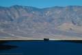
Walk across Death Valley on Badwater Salt Flats.

Total Distance: 6.4 mile shuttle or 11.6 miles out & backElevation Gain: 420ft. (-253ft. to -282ft.)
Difficulty: Moderately Strenuous10+ Mile Difficulty: Moderately Strenuous
View Rating: 5.0 out of 5.0 starsAuthor’s Rating: 5.0 out of 5.0 stars
Visitor Rating:
(Click to rate)
[Total: 0 Average: 0]
Visitor Difficulty Rating:
(Click to rate)
[Total: 0 Average: 0]
Pets: NoHorses: No
Best Seasons: November-April; impassable in wet weatherSpecial Permits: None
Water Availability: NoneOvernight Options: None unless you continue to the roads off of the West Side Road, where dispersed camping is allowed after a mile.
Trailhead Amenities: Primitive RestroomCrowd Factor: Solitude after Badwater Basin
Trailhead Access: 0.6
Uses: Day hiker icon Backpackers Icon No Horses Icon No Dogs IconTrail Surface: Paved Path Surface Iceon Dirt Trail Surface Icon Off Trail Surface Icon
Features: Views Trail Feature IconHazards: Hot Day Icon No Water Icon Impassable When Wet Hazard Icon Water Hazard Icon Vague Trail Hazard Icon

Mile-by-Mile: Badwater Flats

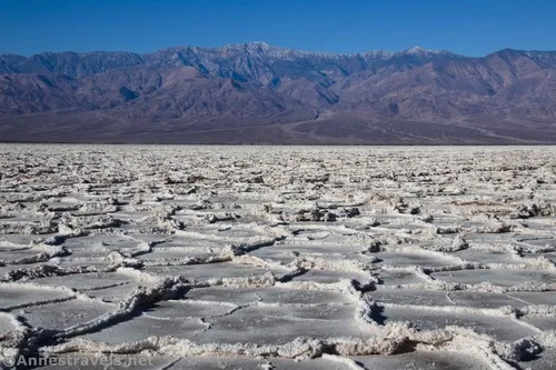
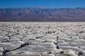
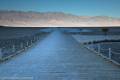
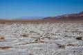
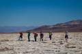
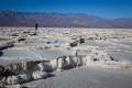
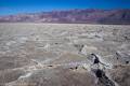
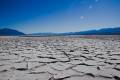
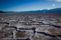
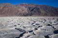
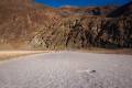
0.0 Badwater Basin Trailhead (-270ft.). Walk either right or left to the stairs to descend down to the boardwalk that goes out to the salt flats. Follow the trail out across the salt flats to where the trail more or less ends in the vast whiteness/brown of the flats. After the trail ends, strike out as straight as possible across the salt flats toward the opposite side. The tread is not easy walking; ridges in the salt flats must be stepped over almost constantly (don’t wreck the beauty of the salt flats by stepping on the ridges). The ridges often contain small salt arches, salt bubbles, or other interesting features. Depending on current conditions, some parts of the salt flats will be pure white. Others will be brown. This is normal. If an area is wet, do not step there – your footprints might last a very, very long time before being washed away. (36.229783°, -116.767435°)

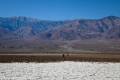
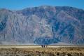
5.8 Vegetation (-269ft.). Once you hit vegetation, you know you have walked across Death Valley. Congratulations! You can either retrace your steps to Badwater Basin or continue to Shortys Well on the West Side Road. (36.227403°, -116.870171°)

6.4 Shortys Well Parking Area (-253ft.). Pick up your shuttle vehicle or retrace your steps to Badwater Basin. (36.226617°, -116.880546°)

History & More

Badwater Basin is about 2 feet higher than the actual lowest point in North America. You might or might not cross a place that’s the famous -282ft. below sea level. But it’s close enough, right?

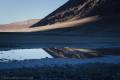
At times, the area between the salt ridges may fill up with water. While this can make for dramatic photos, don’t try to walk on the soft mud. Not only might you get stuck, but your footprints will last a long time, even for years.

It’s said that Badwater Flats received its name from Badwater Basin. A miner tried to drink the water from the pool near the boardwalk, but the water was so salty that he couldn’t drink it.

Badwater Flats cover nearly 200 square miles on the floor of Death Valley.

The ridges of salt are created as water seeps up through the salt flats and evaporates.

The salt flats are mostly made up of sodium chloride (which is just table salt), though there is also calcite, gypsum, and borax on the flats. Don’t trip and fall down – that salt is sharp!

Shortys Well is named for a gold prospecter who came to Death Valley in 1887. “Shorty” Alexander Zachariah Borden never struck it rich on a claim, but his well near the West Side Road brought him fame that continues to this day.

Download Trail Map

Coming soon!

Driving Directions

From the Furnace Creek Visitor Center, head south on CA-190E (a right turn if you’re coming out of the visitor center access road). After 1.3 miles, turn right onto the Badwater Road, following signs for Badwater. Drive 16.5 miles to the parking area for Badwater Basin, on right.

From Death Valley Junction, take CA-190 West 28.9 miles to the Badwater Road; turn left toward Badwater. After 16.5 miles, turn right into the Badwater Basin parking area.

From the south, drive north on the Badwater Road. Badwater Basin is on the left about 30 miles north of Ashford Junction, where the Harry Wade Road joints the Jubilee Pass Road to become the Badwater Road.

Special Permits & RegulationsFees
Remember to take food & water!
Leave No Trace Principles are enforced
Drones and model aircrafts are prohibited
Camping is permitted only in designated sites or in areas open to dispersed backcountry camping
Click here for all park rules and regulations
7 Day Pass: $30/private vehicle. $25/motorcycle. $15/individual (bicycle or on foot).
12 Month Pass: $55/Death Valley Annual Pass (valid at Death Valley National Park). $80/America the Beautiful Annual Pass (valid at all national park and federal fee areas). $20/Annual Senior Pass (62 years or older US citizens; valid at all national park and federal fee areas). Free/4th Grade Pass (Valid Sept. 1-August 31 of the child’s 4th Grade school year). Free/Military Pass (valid for all active military personel and their dependents with a CAC Card or DD Form 1173).
Lifetime Pass: $80/Lifetime Senior Pass (62 years or older US citizens; valid at all national park and federal fee areas). Free/Access Pass (available to all US citizens with perminent disabilities). Free/Access for Veterans and Gold Star Families Pass (valid for all military and veterans with a CAC card, Veteran HJealth Identification Card, Veteran ID Card, or veteran’s designation on state-issued drivers license or identification card.)

Exploring Badwater Flats

Views to Telescope Peak over Badwater Basin, Death Valley National Park, California
Views to Telescope Peak

Thousands of tourists and visitors to Death Valley stop at the Badwater Basin Trailhead. They pose with the sign that says it’s the lowest point in North America at -282ft. But most people don’t go beyond the wide path at the end of the boardwalk. For great views and great bragging rights, you can walk across the salt flats… effectively hiking all of the way across Death Valley!

More afternoon views on the Badwater Salt Flats, Death Valley National Park, California
More afternoon views

Note: There are two times that you should NOT attempt this hike: 1) from May to October or any time the heat is oppressive, and 2) when the salt flats are wet – your footprints in the soft mud could last decades before disappearing!

Badwater boardwalk in the early morning, Death Valley National Park, California
Badwater boardwalk in the early morning

We knew this was an all-day hike, so we started early. Badwater Basin was still in the shadow of the Black Mountains to the east. Five of us had hiked all the way across Death Valley twice before, once in 2006 and again in 2009, and we were thrilled to do it again in 2020.

Reflections in a puddle at Badwater Basin, Death Valley National Park, California
Reflections in a puddle at Badwater Basin

The others had only heard us rave about it – and they’d driven the van around from the West Side Road (Shortys Well, specifically) to Badwater Basin to pick us up both times. This time, we parked at Badwater Basin and did an out-and-back trek – a total of 12 miles – so we could all enjoy the beauty of the Badwater Salt Flats!

Hiking out toward the Badwater Salt Flats, Death Valley National Park, California
Hiking out toward the salt flats

We followed the well-beaten path across the salt flats for about 0.9 miles, then it abruptly ended. From there, we headed in the general direction of the other side of Death Valley. (Actually, to be perfectly honest, we went to the Lowest Point in North America first, but for brevity’s sake, I’ll not go into that in this write-up.)

Brown and white salt flats looking north, Badwater Flats, Death Valley National Park, California
Brown and white salt flats looking north

Sometimes the salt flats are brown. Other times they are white. Exactly what is white or brown is dependent on current conditions. Walking isn’t all that easy because there are constant small ridges to step over. It’s like trying to walk down the sidewalk and not step on any cracks, only the cracks are 6-12” tall.

The ridges you get to step over.  This one is probably about 8-10" tall.  Badwater Flats, Death Valley National Park, California
The ridges you get to step over. This one is probably about 8-10″ tall.

So it’s a constant game of watching your feet, watching where you’re going, watching your feet, making sure you’re going the right way, so on and so forth, all while squinting into the bright dazzle of the reflecting salt crystals. I’m not trying to paint a dismal picture, but this is not an easy, let’s-go-for-a-stroll kind of hike. You’ll have to work for it if you want these bragging rights!

Hikers on Badwater Salt Flats, Death Valley National Park, California
What are they pointing at? I have no idea…

The views of both the salt flat and of the Panamint Mountains to the west (including Telescope Peak) are fantastic! There are rarely crowds this far out on the salt flats, and you’re far enough away that you can’t even see the people. It’s like you’re alone out here in this wild and wacky landscape with all the views to yourself…

Strange leather-like crust on part of Badwater Flats, Death Valley National Park, California
Strange leather-like crust on part of Badwater Flats

Be sure to look for salt bubbles, salt arches, and other formations in the inverted cracks between the “sidewalk pieces” of salty or brown mud. They’re really cool! Thankfully we had a coolish day, so even with the heat rising out of the salt flats, it wasn’t oppressively hot.

A salt bubble.  They're the strangest-looking things!  Badwater Salt Flats, Death Valley National Park, California
A salt bubble. They’re the strangest-looking things!

It’s about 5.8 miles to the western edge of the salt flats. By then, we were pretty tired, and we wouldn’t have minded having a shuttle vehicle to pick us up! But we ate lunch and rested in the shade of a desert plant on a hummock of earth, and that gave us the energy to turn around and head back.

On the western side of Death Valley, looking back toward the Black Mountains and Badwater Basin, Death Valley National Park, California
On the western side of Death Valley, looking back toward the Black Mountains and Badwater Basin

Actually, it can be hard to know exactly when you’ve reached the “far side” of Death Valley. There is brown dirt/dried mud with interesting formations, and plain brown hard dirt, and then the vegetation begins to creep up, slowly, so you don’t really notice it. Then, before you know it, there are green and yellow Arrow Weed all around, and you’re on the other side of Death Valley!

Heading for the western side of Death Valley, California
Heading for the western side of Death Valley

If you’re just hiking across Death Valley and you want a destination on the West Side Road to shoot for, Shortys Well is a good option. The parking area is approximately 36.226617°, -116.880546°. You could also leave a shuttle vehicle there for a 6.4 mile hike.

Hiking back toward Badwater Basin, Death Valley National Park, California
Hiking back toward Badwater Basin

In some ways, heading back was much more difficult because we were tired. It was endless walking across those inverted sidewalk cracks. But in other ways, the views were just as awesome if not better when we were walking east back toward Badwater Basin. In the winter, Telescope Peak is snowy and spectacular while walking west. But I loved the afternoon light on the salt flats in November.

Afternoon on Badwater Flats, Death Valley National Park, California
Afternoon light on the salt flats

(Telescope Peak had just a little visible snow – it was actually much snowier than it looked, as we found out a few days later when we hiked Wildrose Peak.) While the Black Mountains to the east may not be quite as scenic as the Panamint Mountains to the west, they’re none too shabby in their own right!

Walking east toward the Black Mountains, Death Valley National Park, California
Walking east toward the Black Mountains

We arrived back at Badwater Basin late in the afternoon, 11.6 miles of hiking between our same start and end point… but the views along the way were fantastic!

Almost back to Badwater Basin, Death Valley National Park, California
Almost back to Badwater Basin