Upper Fall Canyon – Death Valley National Park


Explore a desert canyon with awesome sheer walls, narrows, and more. Scrambling (Class 3) is required.
| Total Distance: 7.0 to 15.0 miles out & back | Elevation Gain: Up to 4,280ft. (923ft. to 4,016ft.) |
| Difficulty: Easy | 5-10 Mile Difficulty: Easy |
| View Rating: 4.0 out of 5.0 stars | Author’s Rating: 5.0 out of 5.0 stars |
| Visitor Rating: (Click to rate) [Total: 0 Average: 0] | Visitor Difficulty Rating: (Click to rate) [Total: 0 Average: 0] |
| Pets: No | Horses: Yes – but you’d never get a horse up here |
| Best Seasons: November-April | Special Permits: None |
| Water Availability: None | Overnight Options: Yes after about 2 miles |
| Trailhead Amenities: Primitive restroom | Crowd Factor: Solitude to Moderate |
| Trailhead Access: 1.2 | |
| Uses: | Trail Surface: |
| Features: | Hazards: |
Mile-by-Mile: Upper Fall Canyon Route
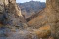
0.0 Fall Canyon Trailhead (933ft.). Follow the Fall Canyon Trail to the 20ft. dryfall. (36.8221167°, -117.1740667°)
3.4 20ft. Dryfall (2,363ft.). Backtrack downcanyon a tenth of a mile to where a rock pile offers access to a cliff face on the southern (left if you’re walking downcanyon) side of the wash. (36.845934°, -117.147280°)
3.45 Route Up (2,341ft.). The route up is sketchy Class 3, especially the first couple of steps. If you can get up these, walk upcanyon a short distance, then follow the water runoff up (south) to where the obvious route crosses over to scramble over a pile of rocks and into the upper canyon. This is not an easy route, and the watercourse borders on a Class 4 scramble. (36.846109°, -117.147779°)
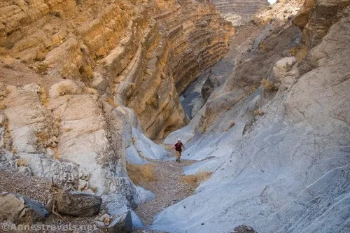
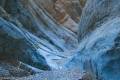
3.5 Top of Dryfall (2,374ft.). The social trail route brings you down slightly above the top of the dryfall, but you can backtrack down the canyon to the dryfall if you wish. Turn right from the end of the social trail to continue upcanyon. Fairly quickly, the canyon walls narrow to slot proportions, with very smooth, highly polished, and sculptured walls. These narrows continue for about a quarter mile before the canyon widens again. (36.845922°, -117.147213°)
3.8 End of narrows (2,474ft.). Continue upcanyon. (36.847533°, -117.143625°)
3.9 Second Narrows (2,491ft.). Work your way through the short, but beautiful and highly-polished, narrows. The narrows end after about 0.1 miles, though the canyon varies in width as you continue upcanyon. The walls tend to be quite tall, which makes the canyon very beautiful. This part of the hike is very remote – there is often more brush in the canyon bottom than in the lower canyon. About mile 6.7 and mile 6.9, two side canyons go off on the right (east) side of Fall Canyon (approx. 36.86483°2, -117.115449° and 36.867051°, -117.116141°, respectively). The second of these is the more interesting, with quite a few small dryfalls to scramble. (36.846081°, -117.142402°)
7.3 2nd 20ft. Dryfall (3,895ft.). The dryfall is highly polished and difficult to climb, although with a lot of upper body strength you may be able to scramble up the left (west) side of the dryfall. To bypass it, walk back downcanyon a few yards (to approx. 36.872845°, -117.115030°) and scramble up the right (east; left as you’re walking downcanyon) side of the canyon and up around the dryfall and back down into the canyon. (36.872984°, -117.115107°)
7.5 3rd Dryfall (4,016ft.). This is the end of the hike for most hikers, as it should be. Climbing through the boulders is for seasoned climbers only. Hikers who don’t mind Class 3+ scrambling over loose rocks with some exposure can climb up to the right (east) to bypass the boulders to continue up Fall Canyon, where there are more narrows, a couple of side canyons, and views of Wahguyhe Peak to the north and Mount Palmer to the west (the head of the canyon is a little over 13 miles from the trailhead). (36.873388°, -117.115156°)
History & More
I’ve heard that Fall Canyon and nearby Titus Canyon are both excellent areas to see bighorn sheep. Sadly, I’ve yet to catch a glimpse of one in the area.
Most hikers only hike part way up Fall Canyon. However, if no rain is in the forecast, there’s nothing stopping you from doing this as a long overnight or multi-day backpacking trip. Just realize that there are no reliable water sources (to my knowledge) in the area.
The first part of the scramble up around the 20ft. dryfall is the worst. Being short, it was even more difficult – thankfully, taller members of my group gave me a helping hand!
Download Trail Map
Coming soon!
Driving Directions
Take Scotty’s Castle Road to Titus Canyon Road (14.9 miles north of CA-190 and 18.3 miles south of the Grapevine Ranger Station). Turn east on the gravel Titus Canyon Road for 2.6 miles to the Titus Canyon Trailhead and Fall Canyon Trailhead parking.
Remember, it may be easier to climb up dryfalls than down them (or vice versa). Be sure you can climb in the other direction before climbing up or down a dryfall.
Leave No Trace Principles are enforced
Drones and model aircrafts are prohibited
Camping is permitted only in designated sites or in areas open to dispersed backcountry camping
All park rules and regulations
12 Month Pass: $55/Death Valley Annual Pass (valid at Death Valley National Park). $80/America the Beautiful Annual Pass (valid at all national park and federal fee areas). $20/Annual Senior Pass (62 years or older US citizens; valid at all national park and federal fee areas). Free/4th Grade Pass (Valid Sept. 1-August 31 of the child’s 4th Grade school year). Free/Military Pass (valid for all active military personel and their dependents with a CAC Card or DD Form 1173).
Lifetime Pass: $80/Lifetime Senior Pass (62 years or older US citizens; valid at all national park and federal fee areas). Free/Access Pass (available to all US citizens with perminent disabilities). Free/Access for Veterans and Gold Star Families Pass (valid for all military and veterans with a CAC card, Veteran HJealth Identification Card, Veteran ID Card, or veteran’s designation on state-issued drivers license or identification card.)