Lower Monarch Canyon – Death Valley National Park


H ike across the desert and up a canyon to a perennial waterfall.
| Total Distance: 6.4 miles out & back | Elevation Gain: 1,017ft. (1,914ft. to 2,691ft.) |
| Difficulty: Moderately Strenuous | 5-10 Mile Difficulty: Moderately Strenuous |
| View Rating: 4.0 out of 5.0 stars | Author’s Rating: 4.0 out of 5.0 stars |
| Visitor Rating: (Click to rate) [Total: 0 Average: 0] | Visitor Difficulty Rating: (Click to rate) [Total: 0 Average: 0] |
| Pets: No | Horses: Yes |
| Best Seasons: November-April | Special Permits: None |
| Water Availability: No potable water | Overnight Options: Dispersed camping permitted at least 1 mile from both the Beatty Cutoff Road and the Daylight Pass Road |
| Trailhead Amenities: None | Crowd Factor: Solitude |
| Trailhead Access: 0.6 | |
| Uses: | Trail Surface:  |
| Features: | Hazards: |
Mile-by-Mile: Monarch Canyon Route
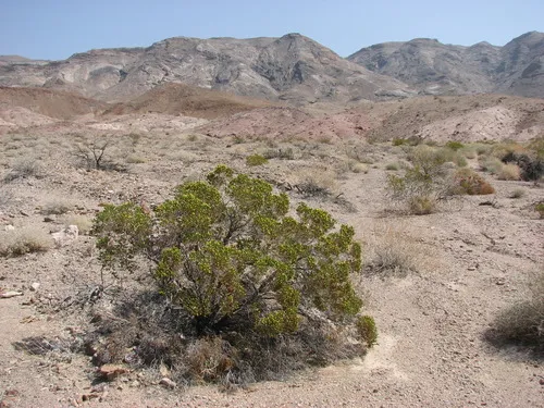
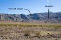
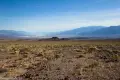
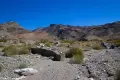
0.0 Unmarked Trailhead (1,984ft.). The exact trailhead may vary; pull onto the shoulder of the road and don’t block traffic. Head west and a little south toward the biggest ravine in this part of the mountains. The terrain is over a gravelly alluvial fan; the walking is easier if you stay slightly right rather than too far north. Head for the right (south) end of some pinkish mounds. You may occasionally see evidence of an old road – the wear of many floods has mostly erased its existence. Be sure to look down on Death Valley, as the views are excellent of Badwater and the surrounding mountains. The views of the Death Valley Buttes to the north are also worth seeing, and Corkscrew Peak pokes its head up to dominate the northern sky. (36.714450°, -116.974831°)
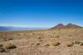
1.2 Enter Main Wash (1,938ft.). Round the end of the pink hills and drop into a wide wash. Turn left (north) to follow Monarch Wash upstream. Along the way, you may pass a post atop a small hill within the wash – when I hiked, a bucket was perched on this post. Pass this hill on its right side and hug the right side of the wash to stay on-track. (36.713401°, -116.955112°)
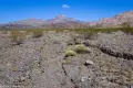
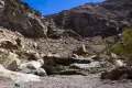
1.75 Wash Splits (2,128ft.). Turn right to follow the main fork west. The canyon rises around the wash, twisting and turning and becoming narrower. (36.715857°, -116.945125°)
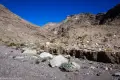
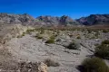
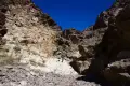
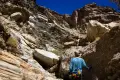
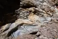
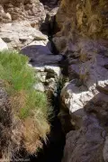
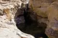
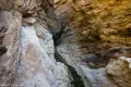
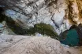
2.9 Canyon Narrows (2,514ft.). The canyon has been slowly narrowing for some time, but now the walls close in. Be ready for a few short scrambles, including two choke stones. The rocky walls have some interesting layering and swirls in this section. About mile 3.0, you’ll begin to see foliage from the water in the canyon. A small drop (10ft.) is below the official waterfall; this is easier to access than the higher, taller falls and has gourds growing near it. To get to the higher falls, backtrack downcanyon a short distance until you can climb up the south (right if coming upcanyon) side via a series of ledges which include a small Class 3 scramble. Keep walking upcanyon to where it seems to end at the waterfall. (36.719329°, -116.928430°)
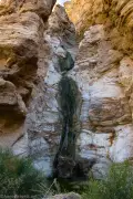
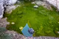
3.2 Monarch Canyon Falls (2,691ft.). The waterfall is made up of several drops including one large one just above the pool. Flow is typically low but still beautiful. Scramble up the left side of the canyon to get a fuller view of the falls. (36.720036°, -116.925374°)
History & More
Some people have found that they could scramble up a steep hillside to the north to bypass the falls. However, the upper canyon is tangled in reeds, muddy, and offers very little in the way of views down on the waterfall. To explore the upper canyon, you’d be better off driving or walking in from the road to Chloride City.
I tried scrambling up the left side of the falls. It was possible for a short distance to a nice overlook with careful scrambling; above this, the rock is too unstable and steep to be safe.
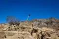
A boomtown was once near Monarch Canyon (thus the old road and the bucket on the post). It’s said that justice was done one day by hanging a miner – but the photographer didn’t show up in time, so the poor dead man was hung a second time so it could be documented for the newspapers back East.
Download Trail Map
Coming soon!
Driving Directions
From Furnace Creek, take CA-190 north 10.6 miles to the junction for the Beatty Cutoff. Turn right toward Beatty. After 9.3 miles of driving north, park along the side of the road.
From the Hell’s Gate (Daylight Pass Road/Beatty Cutoff Junction), drive 0.7 miles south on the Beatty Cutoff Road. Park along the side of the road.
Remember, it may be easier to climb up dryfalls than down them (or vice versa). Be sure you can climb in the other direction before climbing up or down a dryfall.
Leave No Trace Principles are enforced
Drones and model aircrafts are prohibited
Camping is permitted only in designated sites or in areas open to dispersed backcountry camping
All park rules and regulations
12 Month Pass: $55/Death Valley Annual Pass (valid at Death Valley National Park). $80/America the Beautiful Annual Pass (valid at all national park and federal fee areas). $20/Annual Senior Pass (62 years or older US citizens; valid at all national park and federal fee areas). Free/4th Grade Pass (Valid Sept. 1-August 31 of the child’s 4th Grade school year). Free/Military Pass (valid for all active military personel and their dependents with a CAC Card or DD Form 1173).
Lifetime Pass: $80/Lifetime Senior Pass (62 years or older US citizens; valid at all national park and federal fee areas). Free/Access Pass (available to all US citizens with perminent disabilities). Free/Access for Veterans and Gold Star Families Pass (valid for all military and veterans with a CAC card, Veteran HJealth Identification Card, Veteran ID Card, or veteran’s designation on state-issued drivers license or identification card.)
1 thought on “Lower Monarch Canyon – Death Valley National Park”