Big Bell Extension – Death Valley National Park

  Verified Hike
  This is a Rumored Hike. Wayfinding may be required or the route or features may not exist. Travel at your own risk and always obey signs and local regulations.
Beds near the Big Bell Extension, Death Valley National Park, California
Hiking up to the Big Bell Extension, Death Valley National Park, California
Badwater Flats from the Big Bell Extension, Death Valley National Park, California
Corkscrew Peak from the Big Bell Extension, Death Valley National Park, California
Big Bell Extension Trail, Death Valley National Park, California
Mesquite Sand Dunes, Death Valley National Park, California
Big Bell Mine Ruins, Death Valley National Park, California
Corkscrew Peak from the Big Bell Extension Trail, Death Valley National Park, California
John Cyty's Cabin from above, Death Valley National Park, California
Big Bell Extension 1
The Big Bell Extension
Location of the Keane Wonder Trailhead in Death Valley National Park, California
Big Bell Extension 2
Big Bell Extension 3
Big Bell Extension 4
Big Bell Extension 5
Big Bell Extension 6
Big Bell Extension 7
Big Bell Extension 8
Big Bell Extension 9
previous arrow
next arrow
Big Bell Extension, Death Valley National Park, California
previous arrow
next arrow

A steep but very scenic trail up to one of the last purchases of the Keane Wonder Mine.

Total Distance: 6.0 miles out & backElevation Gain: 2,199ft. (1,184ft. to 2,995ft.)
Difficulty: Strenuous5+ Mile Difficulty: Strenuous
View Rating: 5.0 out of 5.0 starsAuthor’s Rating: 4.0 out of 5.0 stars
Visitor Rating:
(Click to rate)
[Total: 0 Average: 0]
Visitor Difficulty Rating:
(Click to rate)
[Total: 0 Average: 0]
Pets: NoHorses: No
Best Seasons: November-AprilSpecial Permits: None
Water Availability: No potable water; no water above John Cyty’s Mill.Overnight Options: Above John Cyty’s Mill; be sure to camp at least 1 mile (as the crow flies) from the Keane Wonder Mine Trail
Trailhead Amenities: NoneCrowd Factor: Solitude
Trailhead Access: 1.2
Uses: Day hiker icon Backpackers Icon No Horses Icon No Dogs IconTrail Surface: Dirt Trail Surface Icon Off Trail Surface Icon Scree/Talus Trail Surface Icon Scramble Class 2 Icon
Features: Mine Trail Feature Icon Views Trail Feature Icon Historic Interest Trail Feature IconHazards: Mine Trail Feature Icon Hot Day Icon No Water Icon Vague Trail Hazard Icon Cliff Edge Hazard Icon Private Property Hazard Icon

Mile-by-Mile: Big Bell Extension Route

0.0 Unmarked Keane Wonder Spring Trailhead (1,317ft.). This is not the Keane Wonder Trailhead; the unmarked, almost unidentifiable trail is located about halfway down the west side of the Keane Wonder Parking Lot. Head west down by the old water tank and locate one of the two trails (there are two trails for much of the hike to John Cyty’s Mill) and follow it generally northwest along the old pipeline to John Cyty’s Cabin & Mill. (36.667797°, -116.910710°)

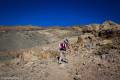
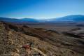
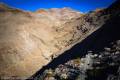
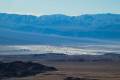
1.2 John Cyty’s Cabin & Mill (1,260ft.). Climb up the vague trail behind the old stamp mill. It fairly quickly becomes more defined and lazily ascends the hillside heading north before beginning a steep, rocky, but stable, trek up into the mountains about mile 1.3. Views as you climb are stunning of Death Valley, the Badwater Salt Flats to the south, and Corkscrew Peak to the north. To the west, after you’ve climbed high enough, Mount Whitney is visible on a clear day. This means you can see the lowest point in North America (Badwater) and the highest peak in the contiguous US (Mt. Whitney) at the same time! Views are especially good just below the saddle. (36.676338°, -116.926834°)

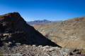
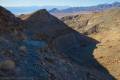
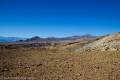
2.6 Saddle (2,728ft.). Views stretch in nearly all directions and are especially good of Corkscrew Peak to the west and up the nearby canyon to the east. Turn right to begin walking on the very narrow but firm track along the canyon edge. This is not a trail for those who dislike heights, as there is a very steep dropoff right next to the trail. Many boreholes have been made into the side of the hill to look for possible ore veins. This area is known as the Big Bell Extension, as it was used as an attempt by John Cyty to expand the Big Bell Mine, which is further up the trail. (36.6893000°, -116.9180333°)

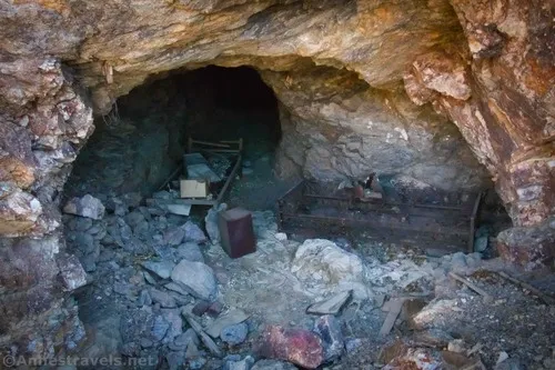
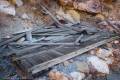
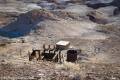
2.9 Big Bell Extension Bore Hole (2,890ft.). Two beds and other debris litter the entrance to the mine. A short distance further up the trail are the remains of an old cabin. The trail after the cabin becomes much more rugged and narrow, but it is still stable. (36.6902333°, -116.9130667°)

3.0 Trail Junction (2,994ft.). The left fork takes you to some old mines, while the right fork takes you up to the Big Bell Mine Ruins. However, to the best of my knowledge, private property begins near here, so it’s best not to go much beyond this point. (36.691680°, -116.911111°)

History & More

John Cyty extracted ore from the mines near the Big Bell Extension. However, the mines did not prove profitable enough to continue work, despite the fact that Mr. Cyty spent years prospecting in the area.

The Big Bell Extension was purchased by the Keane Wonder Mine Company as the original mine began to run dry. While the Big Bell Mine did produce gold ore, it was never as rich or profitable as the Keane Wonder Mine.

Download Trail Map

Coming soon!

Driving Directions

From Furnace Creek, take CA-190 north 10.6 miles to the junction for the Beatty Cutoff. Turn right toward Beatty. After 5.7 miles of driving north, turn right on the gravel road to the Keane Wonder Mine Trailhead, 2.8 miles later.

Additional Warnings & RegulationsSpecial Permits & RegulationsFees
It is illegal to enter any mine, shaft, tunnel, or adit if gated or signed.
It is extremely dangerous to enter a mine due to unstable shafts, gasses, and more. Do not enter mines, even if they are apparently open!
Walking on, climbing, entering, ascending, descending, or traversing any mine, structure, feature, or ruin is prohibited.
Toxic chemicals or ore may be present around mine sites. Enter at your own risk.
Possessing, destroying, injuring, defacing, removing, digging, or disturbing any mine, structure, feature, or ruin is also prohibited.
Remember to take food & water!
Leave No Trace Principles are enforced
Drones and model aircrafts are prohibited
Camping is permitted only in designated sites or in areas open to dispersed backcountry camping
All park rules and regulations
7 Day Pass: $30/private vehicle. $25/motorcycle. $15/individual (bicycle or on foot).
12 Month Pass: $55/Death Valley Annual Pass (valid at Death Valley National Park). $80/America the Beautiful Annual Pass (valid at all national park and federal fee areas). $20/Annual Senior Pass (62 years or older US citizens; valid at all national park and federal fee areas). Free/4th Grade Pass (Valid Sept. 1-August 31 of the child’s 4th Grade school year). Free/Military Pass (valid for all active military personel and their dependents with a CAC Card or DD Form 1173).
Lifetime Pass: $80/Lifetime Senior Pass (62 years or older US citizens; valid at all national park and federal fee areas). Free/Access Pass (available to all US citizens with perminent disabilities). Free/Access for Veterans and Gold Star Families Pass (valid for all military and veterans with a CAC card, Veteran HJealth Identification Card, Veteran ID Card, or veteran’s designation on state-issued drivers license or identification card.)

Big Bell Extension Trail

Views from beyond the saddle on the Big Bell Extension, Death Valley National Park, California
Views from beyond the saddle on the Big Bell Extension

For a truly spectacular hike (that almost no one knows about), try the steep old mining trail behind John Cyty’s Cabin up toward the Big Bell Extension. The views across Death Valley are spectacular and include Corkscrew Peak and both Mt. Whitney (highest point in the contiguous US) and Badwater Flats (lowest point in North America). There are so many desert flats and mountains in view along this trail that it’s breathtaking – pretty literally, since that trail is also very steep!

Views to Badwater Flats from the Big Bell Extension Trail, Death VAlley National Park, California
Views to Badwater Flats

The quick overview of the trail is “a steep, switchbacking hike up to a pass, then a narrow but very stable trail on the very edge of a canyon toward the Big Bell Mine.” We were running out of daylight, so we didn’t make it all the way to the mine. It’s just as well; I hear there is private property up in that area, and since no maps or signs tell you where it is – yet the owners request that you not trespass – it’s probably better to just stick to the known-public land.

Closeup of the Mesquite Sand Dunes from the Big Bell Extension Trail, Death Valley National Park, California
Closeup of the Mesquite Sand Dunes

To get to the Big Bell Extension Trail, you’ll need to first hike to John Cyty’s Mill (1.2 miles from the trailhead). Scramble up the hillside behind the mill. You’ll pretty quickly pick up a faint trail that heads to the left (northwest). It’s a gentle slope for a bit, then it suddenly reaches a hillside and begins switchbacking upward at an alarming rate. From here to the saddle (about 1.2 miles and 1,500ft. of elevation gain) you’ll barely have a flat section of trail.

Looking down on John Cyty's Mill from the trail above en route to the Big Bell Extension, Death Valley National Park, California
Looking down on John Cyty’s Mill from the trail above

However, the trail is very solid. Despite the steep slopes and faintness of the trail, it’s firm underfoot. It’s also not difficult to follow, even though it’s not well-trod.

Hiking up the Big Bell Extension Trail, Death Valley National Park, California
Hiking up the Big Bell Extension Trail

As you rise higher, the views get better. Early on, the views are mostly over Badwater to the south. As you rise higher, you can see all the way to the High Sierras, including Mt. Whitney, and Corkscrew Peak to the northwest.

Views from the lower parts of the switchbacks toward Corkscrew Peak (far right) en route to the Big Bell Extension, Death Valley National Park, California
Views from the lower parts of the switchbacks toward Corkscrew Peak (far right)

At 1.4 miles above John Cyty’s Mill, the trail finally reaches the saddle. Views are spectacular from the trail just before this. In the saddle, you also get great views down into the canyon to the north/east.

Corkscrew Peak from the saddle, Big Bell Extension Trail, Death Valley National Park, California
Corkscrew Peak from the saddle

This is a great turn-around point for a 5.2 mile hike. You’ve seen the best scenery you’ll get on this hike. But if you love history, mines, and all that, continue across the saddle and slightly to the right to pick up the very narrow mining trail that winds along the edge of the canyon.

The trail that leads up the canyon toward the Big Bell Extension, Death Valley National Park, California
The trail that leads up the canyon

The trail is very narrow and slightly rough, and the further you go, the narrower and rougher it becomes. However, it’s very stable, and even when I was putting one foot directly in front of the next, I never felt like I was in danger of falling or the trail slipping down into the canyon. Still, it’s not exactly a trail for those with a fear of heights; it gave me pause and I usually don’t mind such things!

Looking back down the trail toward the saddle on the Big Bell Extension Trail, Death Valley National Park, California
Looking back down the trail toward the saddle

About 0.3 miles beyond the saddle, you’ll come to a borehole with some old beds in it (there are several beginnings of mines along the trail; this one is deeper than many). I’ve no idea why these are here or what they were used for, but we had all kinds of fun imagining renegade outlaws, miners looking for gold, and boy scouts getting patches.

Beds in the entrance to the mine or borehole near the Big Bell Extension Trail, Death Valley National Park, California
Beds in the entrance to the mine or borehole

We continued a short distance beyond this borehole to the ruins of a cabin or other structure that once stood on a wooden platform. While it’s perfectly possible to continue beyond this ruin, the narrow, rough trail becomes even rougher and narrower. We were running against daylight and had other hikers waiting for us back at the trailhead, so we decided we’d better just go back at this point.

The ruined wooden platform where we turned around before getting to the Big Bell Extension Mine, Death Valley National Park, California
The ruined wooden platform where we turned around

I truly enjoyed this hike; it’s a great way to see lots of views and some of Death Valley’s mining past without a lot of crowds and with just a touch of adventure!