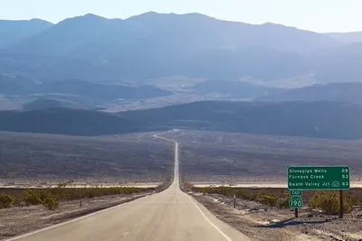
CA-190: Stovepipe Wells to US-395 (Western Border) – Death Valley National Park


Photo credit daveynin, CC BY 2.0. View at https://flic.kr/p/H1VgyX


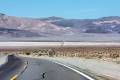


The main road through the western part of Death Valley National Park – from Stovepipe Wells (almost) to US-395. This guide begins where CA-190: Furnace Creek to Stovepipe Wells leaves off.
| Total Distance: 75.8 miles point to point | Elevation Gain: 9,228ft. up, 5550ft. Down (-13ft. to 5,258ft.) |
| Road Difficulty: 0.6 | Bicycle Difficulty: Easy |
| View Rating: 3.0 out of 5.0 stars | Rating: 3.0 out of 5.0 stars |
| Visitor Rating: (Click to rate) [Total: 0 Average: 0] | Visitor Difficulty Rating: (Click to rate) [Total: 0 Average: 0] |
| Pets: Leashed | Horses: No |
| Best Seasons: October-May | Special Permits: None |
| Water Availability: Water is available at both Stovepipe Wells and Panamint Springs and sometimes at Emigrant Campground and the Emigrant Rest Area | Overnight Options: Campgrounds are available in Stovepipe Wells, Emigrant, and Panamint Springs |
| Amenities: Water and services in Stovepipe Wells; lodging in Panamint Springs | Crowd Factor: Moderate |
| Uses: | Road surface: |
| Features: | Hazards: |
Mile-by-Mile: CA-190 Stovepipe Wells to US-395
Note: The mileage in parentheses (for example, (54.3)) are the mileage from where CA-190 begins at Death Valley Junction. For the post about CA-190, Death Valley Junction to Furnace Creek, click here. For the post about CA-190, Furnace Creek to Stovepipe Wells, click here.
0.0 (54.3) Stovepipe Wells Ranger Station on right (-13ft.). This guide picks up from “CA-190: Furnace Creek to Stovepipe Wells.” From the ranger station in Stovepipe Wells, continue to drive west past the rest of the buildings (including the general store, restaurant, and hotel). (36.607798°, -117.144234°)
0.25 (54.5) Cottonwood Canyon Road on right (3ft.). The Cottonwood Canyon Road is a popular 4×4 route to one of the more popular backpacking loops in the park. Across the main road (to the south/left) is the Eichbaum Toll Road historic marker. Continue to drive west as the road begins a slow but relentless climb up to Town Pass. (36.605812°, -117.147565°)
0.4 (54.7) Mosaic Canyon Road on left (east) (35ft.). Mosaic Canyon is one of the most popular slot canyons in the park, with beautiful canyon walls; though the road is dirt, it’s usually fine for most vehicles. The main road continues its upward trend. Use caution during hot weather, and turn off the air conditioning, as most cars have trouble climbing such a steep hill for so long! Pass the Lemoigne Canyon Road on the right (west) about mile 6.25 (approx. 36.538512°, -117.213993°). The scenery in this area tends to be classic desert, with dry mountains on either side of the road across the plains. To the right (north) are the Cottonwood Mountains, while to the south (left) are the Panamint Mountains, including the park’s high point (Telescope Peak). (36.604444°, -117.148558°)
9.1 (63.4) Emigrant Rest Area on the right (west) and the Historic Emigrant Ranger Station on the left (east) (2,128ft.). The ranger station was constructed in the 1930s by the CCCs; the rest area is one of the few nice restrooms in the park (when they’re open!) outside of visitor centers. (36.498107°, -117.226878°)
9.25 (63.5) Emigrant Campground on right (west) (2,171ft.). The campground is first-come, first-serve without a fee and is usually full. It also occasionally closes due to water issues. (36.496528°, -117.226919°)
9.4 (63.7) Emigrant Canyon Road on left (east) (2,218ft.). The Emigrant Canyon Road (ok for 2WD vehicles up to the kilns) takes travelers up Emigrant Canyon to old mine structures, including the famous Wildrose Charcoal Kilns, and the trailhead for Telescope Peak. The grueling grade continues upward on CA-190. The scenery becomes prettier, with mountains closer to the road and with colorfully striped slopes. (36.494953°, -117.227031°)
16.9 (71.2) Towne Pass (4,958ft.). Check your brakes and begin the breath-taking descent into the Panamint Valley – the road is often on cliffs on the edge of the mountains. So while the views are amazing, it can be a bit of a white-knuckle experience! After traveling generally south out of the mountains, the road finally turns west and levels off on a plain between the Cottonwood Mountains and the Argus Range. This is the Panamint Valley. (36.398885°, -117.280327°)
26.0 (80.3) Lake Hill Road on the right (north) (1,567ft.). The road is gravel and suitable for high clearance vehicles for the first 5.75 miles, after which 4×4 is a necessity. (36.341916°, -117.388793°)
28.0 (82.3) Panamint Valley Road on the left (south) (1,578ft.). This road would take you down to Trona and Ridgeway. Continue west (straight) on CA-190. Pass the Panamint Valley Resort about mile 30.6 (36.339759, -117.468218), then begin climbing into the Argus Range. (36.339489°, -117.423652°)
31.6 (85.9) Darwin Wash Road on left (west) (2,118ft.). This sideroad is dirt and requires 4×4 after 2.4 miles. CA-190 continues to climb, with several hairpin curves, cliffhanging maneuvers, and spectacular views back into Panamint Valley. Occasional pulloffs allow for slower traffic to pull over and allow the “parade” behind them to pass. The scenery in this section is interesting, as it has characteristics of a high-alpine environment, but you’re very much still in the desert. (36.339983°, -117.480112°)
38.5 (92.8) Father Crowley Vista on right (north) (4,245ft.). The vista overlooks Rainbow Canyon (sometimes called Star Wars Canyon). CA-190 climbs just a little more before beginning the descent out of Death Valley National Park. (36.351458°, -117.551023°)
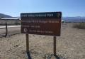
43.3 (97.6) Death Valley National Park Sign on left (south) (4,871ft.). Continue downhill and pass out of the park a short distance later. (36.372926°, -117.610314°)
44.3 (98.6) Saline Valley Road on right (north) (4,864ft.). The dirt road (high clearance required) travels through the western part of Death Valley National Park. Continue west on CA-190. (36.364032°, -117.625860°)
48.4 (102.7) Olancha-Darwin Road on left (southeast) (5,254ft.). The road leads to the ghost town of Darwin, while the road on the right (north) is the Talc City Cutoff. (36.318182°, -117.671890°)
61.3 (115.6) Junction with CA-136; CA-190 turns left (3,798ft.). CA-190 takes a hard left turn here (continuing straight on CA-136 would take you up to Lone Pine). The scenery is more and more like a classic desert plain as you leave the mountains behind. (36.430022°, -117.824371°)
75.8 (130.1) Town of Olancha (3,645ft.). CA-190 ends here in the “town” of Olancha. Turning right or left will take you to US-395. (36.282163°, -118.006111°)
History & More
Stovepipe Wells began welcoming visitors to Death Valley in 1925, when the Stovepipe Wells Resort opened as a simple set of tents on the desert floor. Today, the “town” is still a popular place with campers, lodgers, and more.
The grade up to Towne Pass should not be discounted. Vehicle engines often overheat on the steep grades, especially during hot weather. Coming down is even more dangerous – put your vehicle into low gear to minimize brake usage, as brakes routinely overheat, sometimes causing vehicle fires.
The Emigrant Ranger Station was built in the 1930s by the Civilian Conservation Corps (CCC). In the 1940s, Stan Jones was a ranger in Death Valley and lived at the ranger station. In the lonely hours after work, Stan wrote one of his most famous songs – “Ghost Riders in the Sky.”
On May 20, 2025, a semi-truck experienced a brake failure while descending from Towne Pass. The truck crashed into the historic cabin, destroying two stone columns on the front porch, splintering the roof, breaking windows, and taking out the information sign. The road was closed for 22 hours while crews cleaned up the mess and assessed the damage to the structure.
Father Crowley came west from Massachusetts to be the one and only priest for the Eastern Sierra region. He worked for the economic well-being of all the residents (not just for the few Roman Catholics in the region), including encouraging tourism to the area (especially around Death Valley and Mt. Whitney).
The ghost town of Darwin is still inhabited by a few hardy locals.
Download Road Map
Coming soon!
Driving Directions
Eastern terminus: Stovepipe Wells Ranger Station, 54.3 miles west of Death Valley Junction (Amargosa Opera House) and 24.2 miles west of the Furnace Creek Visitor Center.
Western terminus: Olancha, California, south of Lone Pine along US-395.
Leave No Trace Principles are enforced
Drones and model aircrafts are prohibited
Camping is permitted only in designated sites or in areas open to dispersed backcountry camping
Click here for all park rules and regulations
12 Month Pass: $55/Death Valley Annual Pass (valid at Death Valley National Park). $80/America the Beautiful Annual Pass (valid at all national park and federal fee areas). $20/Annual Senior Pass (62 years or older US citizens; valid at all national park and federal fee areas). Free/4th Grade Pass (Valid Sept. 1-August 31 of the child’s 4th Grade school year). Free/Military Pass (valid for all active military personel and their dependents with a CAC Card or DD Form 1173).
Lifetime Pass: $80/Lifetime Senior Pass (62 years or older US citizens; valid at all national park and federal fee areas). Free/Access Pass (available to all US citizens with perminent disabilities). Free/Access for Veterans and Gold Star Families Pass (valid for all military and veterans with a CAC card, Veteran HJealth Identification Card, Veteran ID Card, or veteran’s designation on state-issued drivers license or identification card.)