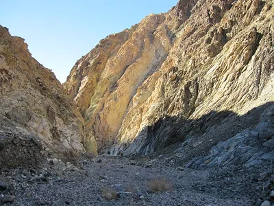
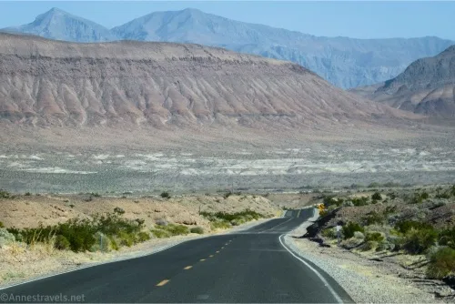
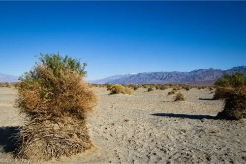
Jubilee Pass Road – Death Valley National Park

The main entrance to the southern part of Death Valley National Park, connecting CA-127 to the south end of the Badwater Road/north end of the Harry Wade Road. Total Distance: 25.0 miles point to point Elevation Gain: 2,016ft. up, 3,632ft. down east to west (3,292ft. to 25ft.) Road Difficulty: 0.6 Bicycle Difficulty: Easy View Rating: […]

Devils Cornfield – Death Valley National Park

A small pulloff allows you to see tall-standing arrowweed plants that early visitors thought looked like bundles of shocked corn. Total Distance: N/A Elevation Gain: 0ft. Difficulty: 0-5 Mile Difficulty: View Rating: Author’s Rating: Visitor Rating: Visitor Difficulty Rating: Pets: Leashed on pavement Horses: No Best Seasons: October-May Special Permits: None Water Availability: None Overnight […]

Military Canyon & Mill BM – Death Valley National Park

An unofficially-named canyon in the Owlshead Mountains south of Drone Canyon and South Drone Canyon. By following the canyon upward, you can reach Mill Benchmark with fantastic views of the surrounding area. Total Distance: 16.2 miles out & back Elevation Gain: 3,026ft. (149ft. to 3,125ft.) Difficulty: 10+ Mile Difficulty: View Rating: Author’s Rating: Visitor Rating: […]

Drone Canyon – Death Valley National Park

An unofficially-named canyon in the Owlshead Mountains south of South Quartz Canyon. Total Distance: 12.8 miles out & back Elevation Gain: 2,276ft. (1,49ft. to 2,413ft.) Difficulty: 10+ Mile Difficulty: View Rating: Author’s Rating: Visitor Rating: Visitor Difficulty Rating: Pets: No Horses: Yes Best Seasons: November-April Special Permits: None Water Availability: No potable or reliable water […]

South Quartz Canyon – Death Valley National Park

An unofficially-named canyon in the Owlshead Mountains south of Quartz Canyon. Total Distance: 13.6 miles out & back Elevation Gain: 2,404ft. (1,49ft. to 2,491ft.) Difficulty: 10+ Mile Difficulty: View Rating: Author’s Rating: Visitor Rating: Visitor Difficulty Rating: Pets: No Horses: Yes Best Seasons: November-April Special Permits: None Water Availability: No potable or reliable water Overnight […]

Quartz Canyon – Death Valley National Park

An unofficially-named canyon in the Owlshead Mountains just south of Wind Cave Canyon. The two canyons are sometimes completed as a loop. Total Distance: 11.6 miles out & back Elevation Gain: 2,006ft. (149ft. to 2,147ft.) Difficulty: 10+ Mile Difficulty: View Rating: Author’s Rating: Visitor Rating: Visitor Difficulty Rating: Pets: No Horses: Yes Best Seasons: November-April […]

Wind Cave Canyon – Death Valley National Park

An unofficially-named canyon in the Owlshead Mountains north of Quartz Canyon. The canyon was named for the unusual number of “caves” (small to large holes in rocks) along the sides of the canyon. Total Distance: 7.4 miles out & back Elevation Gain: 1,307ft. (148ft. to 1,449ft.) Difficulty: 5-10 Mile Difficulty: View Rating: Author’s Rating: Visitor […]

Owlshead Slots – Death Valley National Park

An unofficially-named canyon in the Owlshead Mountains just south of Sand Canyon. Slots are rare in the Owlshead Mountains, so this is a unique feature. Total Distance: 6.8 miles out & back Elevation Gain: 1,293ft. elevation gain (148ft. to 1,366ft.) Difficulty: 5-10 Mile Difficulty: View Rating: Author’s Rating: Visitor Rating: Visitor Difficulty Rating: Pets: No […]

Sand Canyon – Death Valley National Park

An unofficially-named canyon in the Owlshead Mountains differentiated by sandy “dunes” near its mouth. Total Distance: 12.0 miles out & back Elevation Gain: 2,305ft. (147ft. to 2,396ft.) Difficulty: 10+ Mile Difficulty: View Rating: Author’s Rating: Visitor Rating: Visitor Difficulty Rating: Pets: No Horses: Yes Best Seasons: November-April Special Permits: None Water Availability: No potable or […]

Latest Trails

2WD Dirt Road Access 4x4 Access 4x4 Dirt Road Backpacking badlands Badwater Road Bicycles Black Mountains CA-190 California canyon colorful rocks Cottonwood Mountains Day Hiking Death Valley National Park Dirt Road Easy Hike Extremely Strenuous Hike Funeral Mountains Geological Interest Ghost Town Grapevine Mountains Harry Wade Road High Clearance Access High Clearance Dirt Road Historic Interest Horses Jeeps Mine Moderate Hike Moderately Strenuous Hike Owlshead Mountains Panamint Mountains Paved Road Access Pets point of interest rock formations Rumored Hike Spring Strenuous Hike Titus Canyon Road Verified Hike Very Strenuous Hike views West Side Road

Categories

Archives