Devils Cornfield – Death Valley National Park


A small pulloff allows you to see tall-standing arrowweed plants that early visitors thought looked like bundles of shocked corn.
| Total Distance: N/A | Elevation Gain: 0ft. |
| Difficulty: Moderate | 0-5 Mile Difficulty: Moderate |
| View Rating: 4.0 out of 5.0 stars | Author’s Rating: 2.0 out of 5.0 stars |
| Visitor Rating: (Click to rate) [Total: 0 Average: 0] | Visitor Difficulty Rating: (Click to rate) [Total: 0 Average: 0] |
| Pets: Leashed on pavement | Horses: No |
| Best Seasons: October-May | Special Permits: None |
| Water Availability: None | Overnight Options: None |
| Trailhead Amenities: None | Crowd Factor: Moderate |
| Trailhead Access: 0.6 | |
| Uses: | Trail Surface: |
| Features: | Hazards: |
Mile-by-Mile: Devils Cornfield
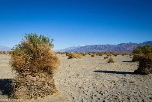
0.0 Devils Cornfield Pulloff (-70ft.). There are pulloffs on both sides of the highway; the northern pulloff has an informational sign. Look out across the valley to the arrowweed atop tall but narrow piles of dirt. Wind has blown soil from around the bases of the plants, making a “field” that looks like it is filled with shocks of harvested corn. Explore if you wish before returning to your vehicle. (36.616273°, -117.071871°)
History & More
“Shocked” corn is not surprised – it’s a term that refers corn stalks that have been tied into a bundle. In a day when most people had at least a general knowledge of farming, seeing shocks of corn in a harvested field was a regular occurrence. Many early travelers had shocked corn, themselves, on farms in the eastern US.
Arrowweed received its name because the local tribes used the plant’s branches as shafts for their arrows.
At one time, the surrounding area was as high as the tops of the piles of dirt. Over time, wind and weather eroded the loose dirt and sand away to the current ground level. However, the arrowweed (and nearby mesquite bushes) so entwined its roots in the soil that it couldn’t fly away in the wind. This makes the plants sit atop a mound of dirt quite a bit taller than the surrounding desert.
Driving Directions
The pulloffs are located along CA-190, 19.7 miles north (west) of Furnace Creek and 4.5 miles east (south) of Stovepipe Wells (2.6 miles west of the North Highway junction).
Leave No Trace Principles are enforced
Drones and model aircrafts are prohibited
Camping is permitted only in designated sites or in areas open to dispersed backcountry camping
Click here for all park rules and regulations
12 Month Pass: $55/Death Valley Annual Pass (valid at Death Valley National Park). $80/America the Beautiful Annual Pass (valid at all national park and federal fee areas). $20/Annual Senior Pass (62 years or older US citizens; valid at all national park and federal fee areas). Free/4th Grade Pass (Valid Sept. 1-August 31 of the child’s 4th Grade school year). Free/Military Pass (valid for all active military personel and their dependents with a CAC Card or DD Form 1173).
Lifetime Pass: $80/Lifetime Senior Pass (62 years or older US citizens; valid at all national park and federal fee areas). Free/Access Pass (available to all US citizens with perminent disabilities). Free/Access for Veterans and Gold Star Families Pass (valid for all military and veterans with a CAC card, Veteran HJealth Identification Card, Veteran ID Card, or veteran’s designation on state-issued drivers license or identification card.)