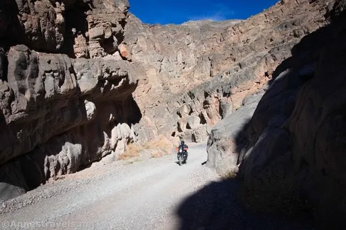
Titus Canyon Road – Death Valley National Park

Follow a gravel road to views, an old mining community, petroglyphs, and a slot canyon. Total Distance: 26.3 miles point to point (one-way road) Elevation Gain: 3,060ft. up, 6,302ft. down (5,261ft. to 175ft.) Road Difficulty: 1.5 Bicycle Difficulty: More Difficult View Rating: Author’s Rating: Visitor Rating: Visitor Difficulty Rating: Pets: Leashed Horses: Yes Best Seasons: […]

Monarch Canyon Road – Death Valley National Park

Rough dirt road down Upper Monarch Canyon to an old miner’s trail. Total Distance: 0.7 miles point to point (dead end) Elevation Gain: 12ft. up, 237ft. down (3,512ft. to 3,287ft.) Road Difficulty: 1.8 Bicycle Difficulty: More Difficult View Rating: Author’s Rating: Visitor Rating: Visitor Difficulty Rating: Pets: Leashed Horses: Yes Best Seasons: October-May Special Permits: […]

Keane Spring – Death Valley National Park

Follow an old mining road to a desert spring. Total Distance: 1.2 miles out & back Elevation Gain: 331t. (3,622ft. to 3,853ft.) Difficulty: 0-5 Mile Difficulty: View Rating: Author’s Rating: Visitor Rating: Visitor Difficulty Rating: Pets: No Horses: Yes Best Seasons: November-April Special Permits: None Water Availability: No potable water Overnight Options: Dispersed camping is […]

Chloride Cliffs Road – Death Valley National Park

Dirt road from US-95 to the Chloride City Road. Total Distance: 11.5 miles point-to-point Elevation Gain: 1,554ft. up, 119ft. down (2,913ft. to 4,405ft.) Road Difficulty: 2.0 Bicycle Difficulty: More Difficult View Rating: Rating: Visitor Rating: Visitor Difficulty Rating: Pets: Leashed Horses: Yes Best Seasons: October-May Special Permits: None Water Availability: None Overnight Options: Dispersed camping […]

Chloride City Road – Death Valley National Park

Rough dirt road to the site of Chloride City, one of the earliest mining areas in Death Valley. Total Distance: 7.5 miles point to point (dead end) Elevation Gain: 2,357ft. up, 498ft. down (3,412ft. to 5,275ft.) Road Difficulty: 2.5 (1.7 for the first 2.2 miles to the Monarch Canyon Spur Road) Bicycle Difficulty: Very Difficult […]

Corkscrew Peak – Death Valley National Park

Take a very official social trail to a peak in the Grapevine Mountains and great views of Death Valley. Total Distance: 7.5 miles out & back Elevation Gain: 3,284ft. (2,669ft. to 5,784ft.) Difficulty: 5-10 Mile Difficulty: View Rating: Author’s Rating: Visitor Rating: Visitor Difficulty Rating: Pets: No Horses: Yes (not recommended) Best Seasons: November-April Special […]

Daylight Peak – Death Valley National Park

Climb an unofficially named peak to the west of Daylight Pass to spectacular views. Total Distance: 2.0 miles out & back Elevation Gain: 1,261ft. (4,321ft. to 5,516ft.) Difficulty: 0-5 Mile Difficulty: View Rating: Author’s Rating: Visitor Rating: Visitor Difficulty Rating: Pets: No Horses: Yes Best Seasons: November-April Special Permits: None Water Availability: No potable water […]

Daylight Spring – Death Valley National Park

Take an old road from Daylight Pass up to the brush around a spring in the desert. Total Distance: 0.6 miles out & back Elevation Gain: 131ft. (4,321ft. to 4,436ft.) Difficulty: 0-5 Mile Difficulty: View Rating: Author’s Rating: Visitor Rating: Visitor Difficulty Rating: Pets: No Horses: Yes Best Seasons: November-April Special Permits: None Water Availability: […]

Hole in the Rock Spring – Death Valley National Park

Follow an old trail up to a spring in the desert. Total Distance: 0.9 miles out & back Elevation Gain: 262ft. (2,729ft. to 2,880ft.) Difficulty: 0-5 Mile Difficulty: View Rating: Author’s Rating: Visitor Rating: Visitor Difficulty Rating: Pets: No Horses: Yes Best Seasons: November-April Special Permits: None Water Availability: No potable water Overnight Options: None […]

Latest Trails

2WD Dirt Road Access 4x4 Access 4x4 Dirt Road Backpacking badlands Badwater Road Bicycles Black Mountains CA-190 CA-190 East California canyon colorful rocks Day Hiking Death Valley National Park Dirt Road Easy Hike Extremely Strenuous Hike Funeral Mountains Geological Interest Ghost Town Grapevine Mountains Harry Wade Road High Clearance Access High Clearance Dirt Road Historic Interest Horses Jeeps Mine Moderate Hike Moderately Strenuous Hike Owlshead Mountains Panamint Mountains Paved Road Access Pets point of interest rock formations Rumored Hike Spring Strenuous Hike Titus Canyon Road Verified Hike Very Strenuous Hike views West Side Road

Categories

Archives