4×4 Road: Deadman Pass Road – Death Valley National Park


Drive across Deadman Pass in the Greenwater Mountains between Greenwater Valley Road and CA-127.
| Total Distance: 13.4 miles point to point | Elevation Gain: 341ft. up, 1,278ft. down (3,264ft. to 2,065ft.) |
| Road Difficulty: 2.0 (4×4 required) | Bicycle Difficulty: More Difficult |
| View Rating: 4.0 out of 5.0 stars | Author’s Rating: 3.0 out of 5.0 stars |
| Visitor Rating: (Click to rate) [Total: 0 Average: 0] | Visitor Difficulty Rating: (Click to rate) [Total: 0 Average: 0] |
| Pets: Leashed | Horses: Yes |
| Best Seasons: October-May | Special Permits: None |
| Water Availability: None | Overnight Options: Yes at least 2 miles from CA-127 and at least 1 mile from the Greenwater Valley Road |
| Amenities: None | Crowd Factor: Solitude |
| Uses: | Road surface: |
| Features: | Hazards: |
Mile-by-Mile: Deadman Pass Road
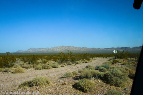
0.0 Deadman Pass Road on the Greenwater Valley Road (3,001ft.). Turn east onto the gravel road. Some say that the road is passable by high-clearance vehicles up to the pass, but to get to CA-127, you’ll need 4×4 due to loose gravel. The road heads northeast in a fairly straight line until it drops into a wash about mile 3.9, turns north-northeast, and ascends up to Deadmans Pass. (36.050658°, -116.500158°)
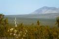
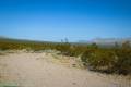
4.5 Deadman Pass (3,264ft.). This is as far as 2WD vehicles should venture. The road crosses the pass and descends down toward CA-127. Drive slowly, as washouts are frequent and sometimes invisible until you’re nearly on top of them. Pass an old road at mile 11.9; actually, there are several old roads in this area, some of which are more drivable than others. Try to stay on the main road. The last two miles before you reach the highway have especially deep gravel that must be negotiated. (36.097984°, -116.445426°)
13.4 CA-127 (2,065ft.). This is one entrance; others have suggested entrances further north including 36.210896°, -116.396070° and 36.222764°, -116.408866° (the latter of which would require some fancy navigation to make sure you get on the right road if you’re coming from CA-127). The truth of the matter is that there are quire a few roads in this section, and which one you take will determine exactly where you come out. Turn right to go south to Shoshone and I-15 in Baker, or turn left to travel north up to Death Valley Junction and up to US-95 in Amargosa Valley. (36.209945°, -116.389406°)
History & More
Deadman Pass Road was originally created to bring freight to the miners near Greenwater and Gold Valley. At the time, the nearest rail depot was at Death Valley Junction.
It’s hard to say who died in Deadman Pass. Death wasn’t all that uncommon in the desert, especially with the rivalry between various mining camps and claims, not to mention the lack of readily available water and supplies.
Deadman Pass Road is known as being 4×4 only. However, the NPS suggests that it may be passable to 2WD, high-clearance vehicles up to Deadman Pass. Beyond this, the road has deep gravel that requires 4×4 – the 2 miles closest to CA-127 are especially bad.
Speaking of the section of road closest to CA-127, multiple old mining roads grid across the area. I’ve attempted to direct you down the correct road, but it’s iffy whether or not I exactly succeeded. Try to take the main road and follow any signs that may (or more likely are not) present.
Deadman Pass Road is not a quick trip. Multiple drainages often wash out, creating bumpy conditions. It’s recommended that you take it slow to avoid hitting an unseen gully – which could perhaps cause the vehicle to launch.
It’s said that the road is very difficult to find if you’re driving on CA-127 – slow down and look for a sandy dirt track across the road from Eagle Mountain.
Download Route Map
Driving Directions
Take the Greenwater Valley Road 18.2 miles south of Dantes View Road (or 10.1 miles north of Jubilee Pass Road). Turn east (left if coming from Dantes View and right if coming from Jubilee Pass) onto the Deadman Pass Road.
Camping in a canyon is discouraged due to the danger of flash floods.
Remember, it may be easier to climb up dryfalls than down them (or vice versa). Be sure you can climb in the other direction before climbing up or down a dryfall.
Camping is not allowed within one mile of a paved road, developed area, or dirt road that is closed to camping.
Camping is not permitted within 100 feet of a flowing stream, spring, or other natural body of open water.
No camping is permitted on the floor of Death Valley, within one mile of Darwin Falls and Greenwater Canyon, on the active/shifting sand dunes, and certain other canyons and backcountry areas.
Camping is also prohibited within one mile of the Ubehebe Lead Mine, Leadfield Mines, Keane Wonder Mill, and Skidoo Mill.
Camping is limited to 30 days per calendar year within the park.
Fires are permitted in NPS-provided fire grates or grills ONLY.
Leave No Trace Principles are enforced
Drones and model aircrafts are prohibited
Camping is permitted only in designated sites or in areas open to dispersed backcountry camping
All park rules and regulations
12 Month Pass: $55/Death Valley Annual Pass (valid at Death Valley National Park). $80/America the Beautiful Annual Pass (valid at all national park and federal fee areas). $20/Annual Senior Pass (62 years or older US citizens; valid at all national park and federal fee areas). Free/4th Grade Pass (Valid Sept. 1-August 31 of the child’s 4th Grade school year). Free/Military Pass (valid for all active military personel and their dependents with a CAC Card or DD Form 1173).
Lifetime Pass: $80/Lifetime Senior Pass (62 years or older US citizens; valid at all national park and federal fee areas). Free/Access Pass (available to all US citizens with perminent disabilities). Free/Access for Veterans and Gold Star Families Pass (valid for all military and veterans with a CAC card, Veteran HJealth Identification Card, Veteran ID Card, or veteran’s designation on state-issued drivers license or identification card.)