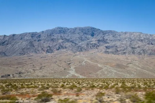
Bighorn Gorge – Death Valley National Park




An off-trail hike that is often backpacked into a desert canyon with dryfalls and short stretches of narrows.
| Total Distance: 20 miles out & back | Elevation Gain: 5,414ft. (1,456ft. to 5,056ft.) |
| Difficulty: Easy | 10+ Mile Difficulty: Easy |
| View Rating: 3.0 out of 5.0 stars | Author’s Rating: 3.0 out of 5.0 stars |
| Visitor Rating: (Click to rate) [Total: 0 Average: 0] | Visitor Difficulty Rating: (Click to rate) [Total: 0 Average: 0] |
| Pets: No | Horses: Yes |
| Best Seasons: November-April | Special Permits: None |
| Water Availability: None | Overnight Options: Dispersed camping permitted at least 2.0 miles from Scotty’s Castle Road |
| Trailhead Amenities: None | Crowd Factor: Solitude |
| Trailhead Access: 0.6 | |
Uses:     | Trail Surface:      |
Features:    | Hazards:     |
Mile-by-Mile: Bighorn Gorge Route
0.0 Unmarked Bighorn Gorge Trailhead on Scotty’s Castle Road (1,685ft.). Travel southwest toward the mouth of Bighorn Gorge. There is no trail, so you’ll be walking cross-country across the alluvial fan of the wash. (36.935531°, -117.321791°)
1.2 Death Valley Wash (1,456ft.). Cross over the wash and begin climbing the gravely drainage into Bighorn Gorge. Many people choose to walk up on the rim of the wash, as the footing is easier than in the wash bottom. (36.924762°, -117.336722°)
3.75 Wash on right (2,436ft.). Continue left (west) in the main wash. Shortly after this, the walls begin to rise to create the Lower Canyon of Bighorn Gorge. The canyon remains relatively wide even as the hills rise on either side. (36.900837°, -117.370425°)
4.2 Mouth of Bighorn Gorge (2,620ft.). The canyon remains wide and a slog up gravel as it winds into the mountains. (36.898632°, -117.378745°)
6.9 Major sidecanyon on left (east) (3,601ft.). Take the right fork – while the sidecanyon can be explored, as it is about 3 miles long and contains dryfalls and narrows, it is difficult work, so this guide continues up the main Bighorn Gorge by taking the right fork. (36.866678°, -117.389560°)
7.2 First Narrows (3,726ft.). These are not very pronounced, but they do contain a couple of interesting chutes, including your first dryfall. The second narrows (approx. Mile 7.75; 36.863253°, -117.396351°) contain a 7ft. sheer, polished dryfall which can be difficult to climb, while the third narrows a short distance upstream are the narrowest and most winding in the gorge. The fourth narrows (approx. mile 9.2; 36.851368°, -117.402703°) has another 7ft. Sheer and polished dryfall. The fifth narrows a short distance upcanyon lead to an 80ft. dryfall (which some would call a 15ft. falls and a 60ft. falls). It looks impassible, but a very faint social trail on the right (north/west) leads up the scree and back into the gorge above the fall. As you hike up the canyon, keep your eyes open for fossils in the rocks (especially below the third narrows), as well as colorful rock layers (especially in the upper canyon). In general, the gorge is quite rough and rocky, so it’s not the for the feint of heart, while the walls are polished limestone. There may be other small obstacles not mentioned here. (36.865199°, -117.391714°)
10.0 Top of Bighorn Gorge (5,056ft.). Enjoy the views up the wash before returning back down the canyon (note that descending the dryfalls is often more difficult than climbing them; use caution). It is possible to continue up the wash above the gorge; however, few people do due to the hike’s length. Those with a high clearance vehicle can take the White Top Road to descend Bighorn Gorge from above. (36.844049°, -117.409145°)
History & More
You may want to take a map (and know how to use it) while exploring Bighorn Gorge – there are many, many sidecanyons, and it can be tricky to figure out which branch is the main canyon.
Bighorn Gorge is probably named for the bighorn sheep that frequent the area.
This is one of the more popular backpacking trips in Death Valley National Park, despite the lack of trail or markings and the difficulty of scrambling the narrows. Backpacking in Death Valley is made more difficult by the lack of reliable water sources.
Most people do not travel beyond the base of the upper dryfall, as doing so is not recommended by the NPS. There isn’t much to see in the upper canyon, so climbing the slope is up to your discretion.
Use care on the dryfalls, as some are slippery and/or difficult to maneuver, especially with a large pack. Remember that climbing down the dryfalls is often more difficult than climbing up them.
Be sure to keep your eyes open for fossils and other interesting marks and features in the rocks of the gorge.
Download Trail Map
Coming soon!
Driving Directions
From CA-190 east of Stovepipe Wells and north of Furnace Creek, take the Scotty’s Castle Road 28.2 miles to the unmarked trailhead. The trailhead is about 5 miles south of the Grapevine Ranger Station.
Camping in a canyon is discouraged due to the danger of flash floods.
Remember, it may be easier to climb up dryfalls than down them (or vice versa). Be sure you can climb in the other direction before climbing up or down a dryfall.
Camping is not allowed within one mile of a paved road, developed area, or dirt road that is closed to camping.
Camping is not permitted within 100 feet of a flowing stream, spring, or other natural body of open water.
No camping is permitted on the floor of Death Valley, within one mile of Darwin Falls and Greenwater Canyon, on the active/shifting sand dunes, and certain other canyons and backcountry areas.
Camping is also prohibited within one mile of the Ubehebe Lead Mine, Leadfield Mines, Keane Wonder Mill, and Skidoo Mill.
Camping is limited to 30 days per calendar year within the park.
Fires are permitted in NPS-provided fire grates or grills ONLY.
Leave No Trace Principles are enforced
Drones and model aircrafts are prohibited
Camping is permitted only in designated sites or in areas open to dispersed backcountry camping
All park rules and regulations
12 Month Pass: $55/Death Valley Annual Pass (valid at Death Valley National Park). $80/America the Beautiful Annual Pass (valid at all national park and federal fee areas). $20/Annual Senior Pass (62 years or older US citizens; valid at all national park and federal fee areas). Free/4th Grade Pass (Valid Sept. 1-August 31 of the child’s 4th Grade school year). Free/Military Pass (valid for all active military personel and their dependents with a CAC Card or DD Form 1173).
Lifetime Pass: $80/Lifetime Senior Pass (62 years or older US citizens; valid at all national park and federal fee areas). Free/Access Pass (available to all US citizens with perminent disabilities). Free/Access for Veterans and Gold Star Families Pass (valid for all military and veterans with a CAC card, Veteran HJealth Identification Card, Veteran ID Card, or veteran’s designation on state-issued drivers license or identification card.)